
地形对碎屑流冲出的影响作用
2011-01-27 01:12苏志满鵜飼恵三杨情情徐林荣
地震工程学报 2011年8期
苏志满 , 鵜飼恵三,杨情情,蔡 飞,徐林荣
(1.中南大学土木建筑学院,湖南 长沙 410075,中国;2.群马大学土木与环境工学系,群马 桐生 3768515,日本)
0 Introduction
Rock avalanche is one of the most dangerous and destructive landslide types, because of spectacular long travel distance and unusually large volume of debris involved, which have been extremely costly in human lives and property, and pose us enormous risk even though they situate kilometers from their origin places. Since it is practically impossible to mitigate the destructive potential of this type of event by stabilizing the area of rock failure source, reliable prediction of travel distance could help to estimate the extent of potential impact area, to install preventive facilities, and to plan future activity in valley bottom.A good understanding of run-out behavior is therefore of considerable geotechnical interest.
In the field of theoretical analysis of run-out prediction of rock avalanche, efforts have been made in explaining the high mobility of large rock mass failures and providing run-out predicting methods.Several hypotheses have been proposed to rationalize the recorded or observed phenomena of rock avalanche[1-2], but no general agreement has yet been achieved. As a part of consequence, researches resorted to different analytical approaches to predict run-out, which may be divided into empirical and mechanics methods. Many of the proposed methods were proved to be able to yield the expected results in the back-analysis of real events[3-4]. However, due to the poor understand of the mechanism, simplifying assumptions were present in these methods, which sometimes make it difficult to measure the input parameters or apply them in new areas.
A well-accepted index expressing the mobility of rock avalanche is the angle of line connecting the slide crest and the accumulation tip. This angle has been termed as the angle of reach, and the tangent of it can be generated by the ratio f between the vertical (H)and horizontal projections (L) of the line. An assumption (named Assumption f-V) was suggested that ratio f would decrease with an increase of rock failure volume (V)[5], which was later confirmed for other types of landslides[6]. Therefore several empirical correlations were obtained from regressions of a large number of pairs of V and f values measured on past events. To examine these correlations, many laboratory simulations were performed concerning about the influence effects of material, travel path,initial releasing manner, and so on[7-12], and results of which agreed with the assumption. Of particular interest is the work of Moriwaki H., which revealed an effect of topography on ratio f through both case studies and experimental simulations that the ratio f decreases with the decreasing initial slope[13]. Recent statistical analyses for shallow landslides also ensured the effects of topography on the H/L ratio[14-15].However, most of the attentions were paid to the slope of initial failure part, not to the lower terrain that the failure mass travel and deposit. Nevertheless, in the flume tests the lower portion of flume for deposition always been set horizontal or at a fixed angle, which were not well accordance with the field cases.
Herein, authors performed a series of small scale flume tests to investigate run-out behavior of rock avalanche under different terrain conditions. The angle of reach in each case was calculated and compared with two field cases where large amount of rock failure were induced by strong shaking of earthquake and resulted in long travel distance. Peculiar phenomena were observed in these two cases. The case in Sichuan, China, was named as Xiejiadian rock avalanche, which was triggered by the M8.0 Wenchuan Earthquake, 2008, and two other rock failures were found in neighbor slopes with different run out distance of debris which stopped near the toe of failure slope. The other case locates in West Java,Indonesia, named as Cikangkareng rock avalanche,which was induced by M7.6 Tasikmalaya Earthquake,2009. In Cikangkareng case, the failure rock mass travel downslope and resulted in two different length of run out distance. These phenomena are considered to be related with the topography of travel path, which was examined by flume tests as followings.
1 Flume tests
1.1 Experimental flume and measurement
Experiments were performed in a designed flume as shown in Fig. 1(a). It was made of two straight wooden portions, which could be variably inclined to obtain different geometrical configurations (Fig.1(b)).The angle of lower portion of flume was varied at 0º,10º, 15º, 20º, while the upper portion of flume being fixed at the angle of 45º. Materials mixed by gravel,middle-sized sand, and finer sand were used as sample.This kind of material was found in our previous tests to be with high mobility[16]. The sample was positioned in the upper portion before being released at a height of 50 cm from the joint of two portions.
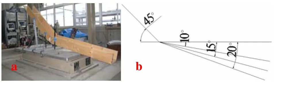
Fig.1 General view of experimental equipment (a) and geometrical configuration of the flume (b).图1 模型槽(a)及其角度变化示意图(b)
In the studies of flume tests, run-out usually refers to the distance traveled by the mass front on the lower portion, while total run out distance was named as travel distance. In our tests, measurements of run-out have been performed by taking into account only the main part of the deposit and neglecting the band around it formed by a layer of one gravel height,and where the particles become less and less concentrated.
1.2 Experimental results and analyses
It was found that run-out of the released granular material changed a lot when the angle of lower portion was varied. The morphology and length of run-out accumulation are shown in Fig.2. There exhibits a trend that travel distance increase sharply with the increase of angle of travel path. The value in the case of 15º is almost as many as three times of the one in the case of 0º. When the angle changed to 20º,most of the materials ran out of the flume, which was totally different with the cases in other angles.
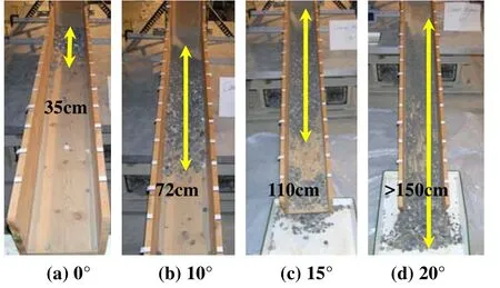
Fig.2 Run-out in each case with different angles.图2 各角度下的冲出情况
The angle of reach in each case was analyzed in the term of H/L, which is known as apparent friction (f)in the literatures[1,7]. According to Assumption f-V that the angle of reach depends on the volume of mass, the value of these cases ought to be similar. However, the results turned out to be that the values of f were different in the cases of 0º, 10º, and 15º, which were respectively 0.59, 0.52, and 0.50. The value in the case of 0º was obviously higher than the other two cases which were almost the same with each other. It is suggested that Assumption f-V should be constrained in a specified range of angle in the lower travel path below the initial failure slope. Further works need to be done to gain an insight into the range.
2 Case Studies
2.1 Xiejiadian Rock avalanche
The site of Xiejiadian rock avalanche situates close to the epicenter of Wenchuan Earthquake which locates in Longmenshan fault belt. Two other rock failures occurred in the same area, the sites of which were respectively named as Qinggang Gully and Jiufeng Mountain. An aerial image was taken right after the earthquake[17], as shown in Fig.3.
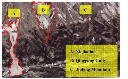
Fig.3 Aerial image covering the area of Xiejiadian site.图3 谢家店地区震后航片
Typical morphology of rock avalanche path was formed in the site of Xiejiadian, comprising an initiation zone, a transportation zone and a zone of terminal deposition[18-19]. The initiation zone locats at the headwall of the gully channel(Fig.4).
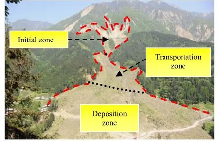
Fig.4 Sketch map of Xiejiadian rock avalanche.图4 谢家店碎屑流分区示意图
In the case of Qinggang Gully, the onset of failure also occurred within a gully channel, but it was on a steep side slope which was different with the case in Xiejiadian. Debris ran into the gully as a consequence of topographic constrain and ceased near the toe of initial slope (Fig.3).
In Jiufeng Montain, rock failures occurred on side slopes with small magnitude, the shape of which looked like scratch trace on the surface of slope.
The case of Jiufeng Mountain could support Assumption f-V in other words that little volume of rock mass would result in a short run-out. However,short run out distance also occurred in Qinggang Gully where large area of slopes lost stability in the earthquake event. The reasons for this may be:
(a) The run out direction of debris mass changed when they fell down to the channel (see to Fig.5)which resulted in the loss of kinetic energy and the reduction of the mobility of movement;
(b) A relatively gentler channel was found lying at the toe of the failure slope, comparing with the one in Xiejiadian site.
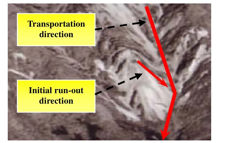
Fig.5 Sketch map of the run out of Qinggang Gully rock failure.图5 青杠沟滑坡碎屑运动示意图
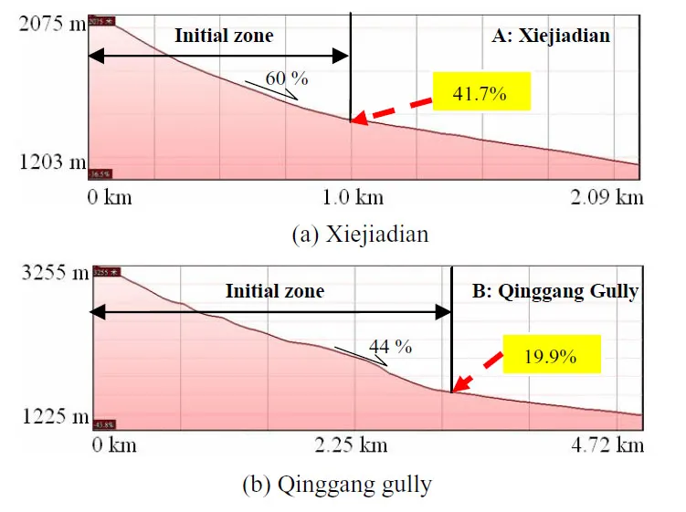
Fig.6 The elevation profiles of channels in the sites of Xiejiadian and Qinggang Gully.图6 谢家店、青杠沟的沟底高程断面图
The later reason was check by Google Earth program. Satellite remote sensing image of this area before Wenchuan Earthquake was obtained, as well as the elevation profiles of channels, as shown in Fig.6.In the initial zone, mean gradient of the channel in Xiejiadian site is 60%, while in Qinggang Gully it is 44%. Besides, at the point of toe of initial zone, the gradient is 41.7% in Xiejiadian site, and 19.9 % in Qinggang Gully. All these terrain data indicated that upon initiation, debris mass in Qinggang Gully travelled in a gentler slope, both in initiation zone and in transport zone. Combined with of the effect of energy loss in the process of changing the moving direction due to topographic constraining, an obvious shorter run out distance was generated in Qinggang Gully rock failure event.
2.2 Cikangkareng rock avalanche
Cikangkareng rock avalanche (Fig.7) area situates in a giant structural collapse in dissected plateau of South Cianjur, West Java Province,Indonesia. The interpretation of this area drawn from IKONOS imagery is shown in Figure 8. It is observed that lower slopes of the escarpment are blocks or talus deposits of older (ancient) landslide which formed a platform with gentle inclination. During the rock avalanche event, these ancient deposits became block barriers against the run-out of debris mass. That was how the rock avalanche ran in narrower shape following a southern gully to the east of main body which was stopped in a shorter travel distance.
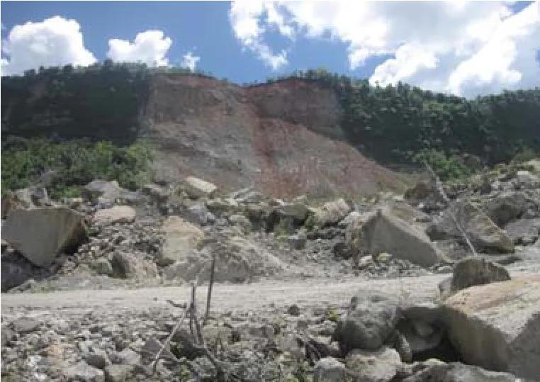
Fig.7 Cikangkareng rock avalanche site.图7 Cikangkareng 碎屑流场点
The topography of this area was interpreted by Google Earth program (Fig.9). The gradient of the chosen points in the travel path was 20.3 % and 8.9 %,respectively for the long run-out debris mass and the short one. Both of the points are 380 m away from the crest of sliding. Apparent friction for the long one is 30%, while the shorter one is 35%.
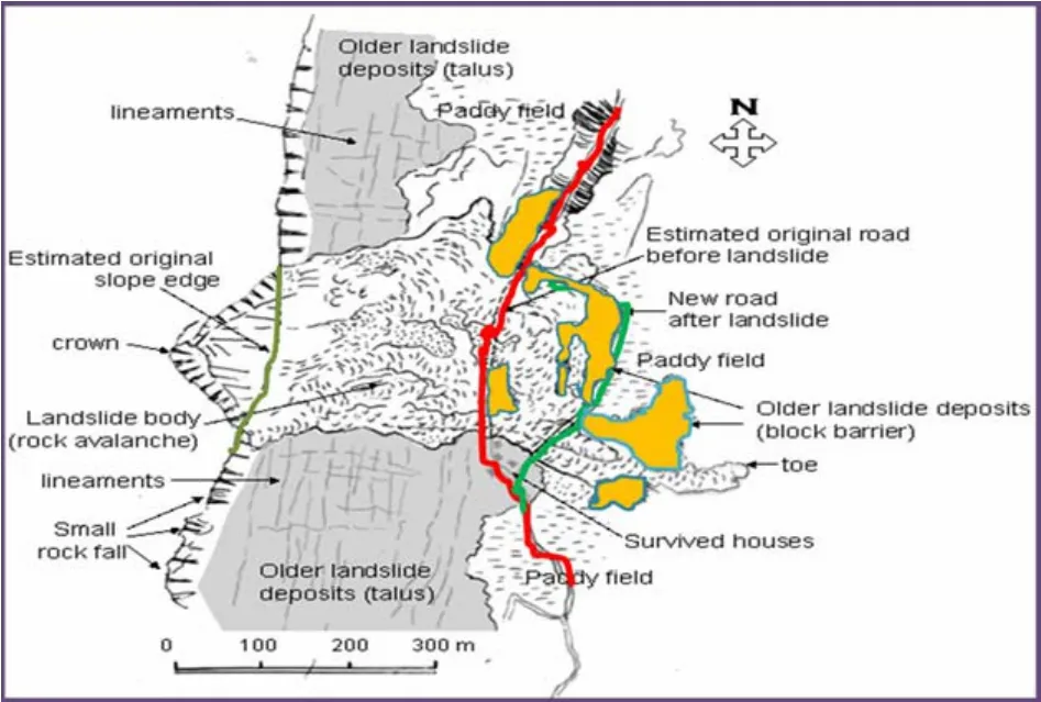
Fig.8 Interpretation of Cikangkareng rock avalanche body.图8 Cikangkareng 碎屑流场点地形解译图
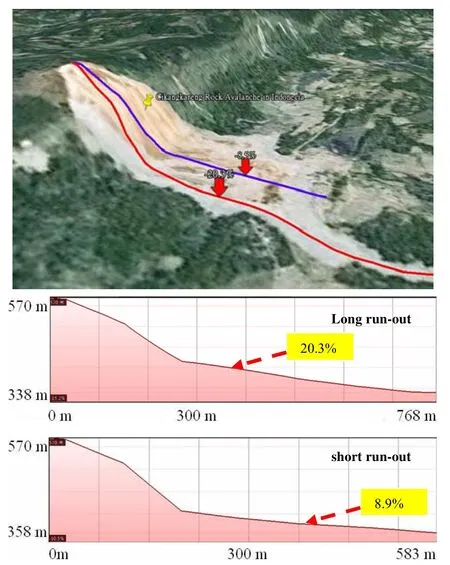
Fig.9 Satellite remote sensing image of the site of Cikangkareng rock avalanche after earthquake(a)and the elevation profiles of the channel (b).图9 Cikangkareng场点震后遥感图片及沟底高程断面图
3 Discussions
According to the test results, gentle slope in the travel path of granular grow would result in the increase of angle reach or decrease of mobility.Several field evidences supporting the result of experimental tests were discovered in both the sites of Xiejiadian rock avalanche and Cikangkareng rock avalanche. The change of the travel directions as a consequence of topography constraint would also weaken the run-out behavior, according to the Qinggang rock failure site neighboring to Xiejiadian site. Without considering these influences of topography factors, a longer travel distance would be predicted as shown in Fig.10. In other words, a segment of slope with gentle inclination and enough length in the travel path would halt the process of run-out of landslide. In Fig.10, rectified angle refers to the angle of reach considering the effect of gentle inclination of travel path, while the expected angle based on the assumption mentioned before.

Fig.10 Comparison of expect distance and rectified distance.图10 预期冲出值与修正冲出值的比较
In the case of Xiejiadian rock avalanche, the angle of reach was 41.7%, which is larger than the ones in Cikangkareng rock avalanche. In fact, the volume of debris involved in Xiejiadian site is much larger by orders of magnitude than in Cikangkareng site, and theoretically basing on Assumption f-V,Xiejiadian rock avalanche was expected to experience a larger mobility with small angle of reach. According to the field investigation, this unexpected phenomenon could be related to the entrainment along the travel path which was covered by ancient deposition with high gradient on the surface. Entrained dry material has generally the consequence of dissipating motion energy which reduces the mobility of debris mass.However, it is worth to note that the increase of involved debris would increase the mobility of debris mass in the following motion. Which effects of entrainment were dominated on the movement presents a considerable challenge for explaining.
In the field of run-out prediction of landslide,empirical methods are regarded as a simple and practical means when little is known about the material or flow path. However, several drawbacks were found in this kind of approach[2], such as that it can’t consider terrain morphological changes along the debris transportation path. The findings of this work about the roles of topography in the run-out of rock avalanche would support the development of empirical approach to modeling travel distance.
4 Conclusions
According to the results of flume test, the angle of reach in the cases with varied angle of run out path but the same material condition revealed to be different, which go against to the conventional assumption that angle of reach depend on the volume of debris involved. Field cases of recent earthquake induced rock avalanche events are studied and evidences supporting the founding from flume tests are observed. Conclusions are drawn as:
(a) Angle of reach of rock avalanche also depends on the topography of travel path, except initial slope;
(b) Gentle segment of slope in the travel path would increase the angle of reach and weaken the mobility of movement;
(c) A smaller value of travel distance would be generated considering the topography effects of gentle inclination and direction constraint, comparing with the expected value based on conventional assumption.
[1]Davies T R H. Spreading of Rock Avalanche Debris by Mechanical Fluidization[J]. Rock Mechanics, 1982, 15: 9-24.
[2]Legros F. The mobility of long-runout landslides[J]. Engineering Geology,2003, 63: 301-331.
[3]Fannin R J, Wise M P W. An empirical-statistical model for debris flow travel distance[J]. Canadian Geotechnical Journal, 2001, 38 (5): 982-994.
[4]Hungr O, Mcdougal L S. Two numerical models for landslide dynamic analysis[J]. Computers & Geosciences, 2009, 35 (5): 978-992.
[5]Scgeudegger E A. On the Prediction of the Reach and Velocity of Catastrophic Landslides[J]. Rock Mechanics, 1973, 5: 231-236.
[6]Corominas J. The angle of reach as a mobility index for small and large landslides[J]. Canadian Geotechnical Journal, 1996, 33: 260-271.
[7]HSÜ K J. Catastrophic debris streams (Sturzstroms) generated by rockfalls[J]. Geological Society of America Bulletin, 1975, 86: 129-140.
[8]Davies T R H, Mcsaveney M J. Runout of dry granular avalanches[J].Canadian Geotechnical Journal. 1999, 36, 313-320.
[9]Okura Y, Kutagara H, Sammori T. Fluidization in dry landslides[J].Engineering Geology, 2000, 56: 347-360.
[10]Valentino R, Barla G, Montrasio L. Experimental analysis and micromechanical modeling of dry granular flow and impacts in laboratory flume tests[J]. Rock Mechanism and Rock Engineering, 2008,41 (1): 153–177.
[11]Manzella I, Labiouse V. Qualitative analysis of rock avalanches propagation by means of physical modelling of not constrained gravel flows[J]. Rock Mechanism and Rock Engineering, 2008, 41 (1): 133-151.
[12]Manzella I, Labiouse V. Flow experiments with gravel and blocks at small scale to investigate parameters and mechanisms involved in rock avalanches[J]. Engineering Geology, 2009, 109: 146-158.
[13]Moriwaki H. A prediction of the runout distance of a debris[J]. Journal of the Japan Landslide Society, 1987, 24 (2):10-16 (In Japanese).
[14]Finlay P J, Mostyn G R, Fell R. Landslide risk assessment: prediction of travel distance[J]. Canadian Geotechnical Journal, 1999, 36: 556-562.
[15]Hunter G, Fell R. Travel distance angle for “rapid” landslides in constructed and natural soil slopes[J]. Canadian Geotechnical Journal,2003, 40: 1123-1141.
[16]Ugai K, Yang Qingqing, Cai Fei,et al..Laboratory flume static and dynamic experiment for rock avalanches [A]// Proceedings of Geo-Shanghai 2010, Soil Dynamics and Earthquake Engineering[C].Geotechnical Special Publication, ASCE, No. 201:278-287.
[17]Qin Xuwen, Yang Jinzhong, Zhang Zhi, et al.. Remote sensing emergency survey in venchuan earthquake area [M]. Beijing: Science Press, 2008:108. (in Chinese)
[18]Yang Qingqing, Su Zhiman, Ugai K, et al.. Recent landslide disasters induced by earthquakes [A]// Proceeding of 5th International Conference on landslides, slope stability & the safety of infrastructures[C]. Kuala Lumpur, Malaysia, 2008:47-52.
[19]Yamada M, Cai Fei, Wang Gonghui. Catastrophic earthquake and mountain hazards in Sichuan[M]. Tokyo: Press of Polytechnic book,2010:86. (in Japanese)
猜你喜欢
中学生博览(2022年7期)2022-06-21
青年文学家(2022年7期)2022-04-24
小学生学习指导(中年级)(2022年3期)2022-03-29
科技进步与对策(2021年12期)2021-06-23
安全(2021年4期)2021-05-19
湖南包装(2020年6期)2021-01-20
广东教育·职教版(2020年5期)2020-06-01
绿色科技(2019年20期)2019-11-26
教育教学论坛(2017年6期)2017-03-04
文贝:比较文学与比较文化(2015年1期)2015-11-14