
基于试验反射光谱数据的土壤含水率遥感反演
2017-12-15 02:53杨曦光
农业工程学报 2017年22期
杨曦光,于 颖
基于试验反射光谱数据的土壤含水率遥感反演
杨曦光1,于 颖2※
(1.东北盐碱植被恢复与重建教育部重点实验室,东北林业大学盐碱地生物资源环境研究中心,哈尔滨 150040; 2. 东北林业大学林学院,哈尔滨 150040)
土壤含水率是土壤水循环研究中不可或缺的参数,已广泛应用于土壤水分的监测。土壤光谱特性的研究是土壤含水率光学遥感定量反演的基础。该研究首先通过野外调查收集土样;然后,在实验室条件下制备不同水分梯度的土壤样品,并利用便携式地物光谱仪采集不同水分梯度土壤样品的反射光谱;最后,通过试验光谱数据分析建立一个基于指数函数的土壤含水率遥感反演模型,并对结果进行精度评价。结果表明,基于指数函数的土壤含水率反演模型可以较好的反演土壤水分特征,在640 nm处土壤含水率的估计值与真实值之间的决定系数为0.7062,RMSE为3.49%。相关研究为表层土壤含水量的遥感监测提供新方法和新思路。
土壤含水率;遥感;模型;指数函数;反演模型;高光谱遥感
0 引 言
土壤含水率是一个重要的土壤物理参数,它是生态系统水循环、植物生长、土壤承载能力等研究领域中必不可少的基本参数[1]。首先,地表土壤含水率影响着地表与大气的水分和能量交换[2]。另外,水是农作物生长发育的基本条件,是保证植被健康生长的重要因素[3],因此,土壤含水率是评价土地资源的重要指标,是精准农业中极为关键的参数,土壤含水率的监测有着十分重要的意义[4-5]。土壤含水率的监测方法和手段也成为人们一直关注的热点问题之一[6]。
目前,常用的区域土壤含水率直接监测方法主要有:取土烘干称质量法、中子仪法、张力计法、频域反射仪法和时域反射仪法等[7]。这些方法比较准确的获得土体剖面含水率,可测定土层较多,但一般都依赖于密集的野外采样[8]。但是这些方法采样成本偏高、调查周期较长、且容易受制于采样时间和采样范围[9]。另外,这些方法以点测量为基础,代表性差,体现区域土壤含水率空间变异性尤为困难[10],难以实现大尺度土壤含水率变化的实时监测和快速更新[11]。
遥感技术以其高效、快速的优势已经应用到土壤属性监测的应用中[12]。利用遥感技术进行大面积、实时的土壤信息提取,实现对区域尺度土壤状况的时空动态监测成为现实[13-17]。而高光谱遥感能够更加精细地反映地物光谱的细微特征,捕捉土壤属性差异引起的反射光谱变化信息,使得土壤属性特别是土壤含水率的定量反演成为可能[18]。研究表明,在小于田间持水量的条件下,土壤反射光谱随着土壤含水率的增加而减小[19],并且这种变化趋势是非线性的[20]。Rijal等[21]利用水分敏感波段与植被指数相结合来获取土壤含水率信息。Zhang等[22]利用偏最小二乘方法建立反射光谱与土壤含水率相关性模型,模型误差为10%。刁万英等[23]利用神经网络方法进行土壤含水率的估算,结果表明基于神经网络的土壤含水率预测精度较高。
土壤是含多种成分的复杂综合体,土壤反射光谱受土壤母质、有机质、地表覆被物、耕作和人类活动等多种因素影响[24-25],降低了土壤含水率遥感估算模型的精度。统计建模方法本身是基于样本数据的建模方法,存在可移植性差和区域局限性等缺点,这些因素限制了遥感技术在土壤水分信息估算方面的应用[26]。本研究以能量在土壤中辐射传输的过程为出发点,研究土壤水分变化对反射光谱的响应特性,建立基于辐射传输理论的土壤含水率光谱反演模型,以期为利用遥感技术进行表层土壤含水量的监测提供新方法和新思路。
1 数据与方法
1.1 土壤数据
研究区位于黑龙江省安达市。在研究区内随机设置了20个野外采样点,收集表层(<10cm)的土壤样品,并用GPS记录采样点坐标。收集样品的土壤类型分别为盐碱土、草甸土、黑钙土、风沙土、沼泽土和水稻土。土壤样品质地为壤质黏土至砂质黏壤土,含黏粒为10%~35%。将不同采样点收集的样品经研磨、风干并过2 mm筛子后混合,然后将混合样品均分成16个独立样品,装入直径为5 cm的土壤盒中。目的是获得土壤结构和属性近似相同的样品,以降低其他土壤因素对反射光谱的影响。再对样品滴淋不同质量的蒸馏水,以获得不同含水率的土壤样品[12,19]。利用烘干法获得样品的含水率数据,测量条件及烘干法操作流程见文献[27]。
1.2 光谱数据采集
利用SVC-1024i便携式光谱仪进行样品反射光谱的测量。实验室光源(Lowel Light Pro., JCV 14.5 V–50 WC)以45°入射角在距样品20 cm的位置照射在样品上,便携式光谱仪在距样品3 cm处测量天顶方向的土壤反射光谱,每个样品测量10次并取平均,以降低仪器和环境噪声[12]。整个测量过程在暗光实验室进行,以避免环境散射光对测量结果的影响[19]。
1.3 研究方法
土壤水分对其反射光谱的影响可以通过指数模型式 (1)来描述[19]。
式中()为湿土壤反射率,R()为干土壤反射率,()为纯水的吸收系数,cm-1,为光程长度,cm。由于这个理论模型不能反应土壤含水率与反射光谱的相互关系,因此,本研究将公式(1)改写为如下形式,以体现土壤含水率与反射光谱的相互关系

式中()表示土壤水分引起的衰减系数,是与波段相关的无量纲变量,表示土壤质量含水率,%。
将公式(2)表达成土壤含水率的函数为

若已知衰减系数(),给定土壤的反射光谱,则可以求解出土壤含水率。
为了求解(),公式(3)可进一步描述为

2 结果与分析
2.1 土壤水分含量对土壤光谱的影响
土壤水分作为土壤的重要组成部分,对土壤的整体反射光谱产生明显的影响。从图1中,可以看出,土壤的反射光谱会随着土壤含水量的不同呈现出明显的差异。由于水分对光谱的吸收,使得土壤反射光谱会随着土壤含水量的增加而降低。而在1 400、1 900和2 200 nm等特定的水分吸收带处,土壤反射率下降尤为明显。这种变化主要是由于土壤中水中羟基集团震动形式决定的[24]。Baumgardner等[28]发现,当土壤含水量增加时,土壤的反照率将会降低,在1 400和1 900 nm处的吸收峰面积会增加。含水量高的土壤反射光谱在1 400和1 900 nm附近吸收峰的深度及面积都要大于含水量低的样品在这2个吸收峰对应的值[29]。但当土壤含水率达到田间持水率之后,反射光谱就不会再随着土壤水分增加而降低了。Muller等[30]研究表明,如果土壤含水率持续增加直至达到田间持水量后,土壤颗粒表面会形成水膜并发生镜面反射,使得土壤反射光谱随着含水量的增加不但不持续降低,反而有所上升。而土壤湿度从干燥态演变到风干态时,土壤发射光谱变化不显著[12]。

图1 不同含水率对应的土壤反射光谱
2.2 衰减系数求解
利用实际测量的不同含水率土壤光谱数据()、土壤含水率数据()以及烘干土壤样品光谱数据(R),根据式(3)和式(4)求解出衰减系数()的值。衰减系数反映了土壤水分对反射光谱的影响,衰减系数越大,说明土壤水分对光辐射能量的吸收作用越强。图2为估计的衰减系数与纯水吸收系数的比较。

注明:纯水吸收系数是基于Hale and Querry数据绘制[31]。
图2虚线部分为利用拟合数据计算的350至2 500 nm的衰减系数()。从图2可以看出,土壤含水率对1 300 nm之前各波段土壤反射光谱的影响近似相同且吸收很小。此后,随着波长的增加,土壤水分对土壤反射光谱的影响增强。在1 300至1 600 nm和1 800至2 100 nm之间有2个明显的吸收峰,吸收峰的中心分别位于1 450和1 930 nm,且1 930 nm处的吸收峰的吸收强度要强于1 450 nm的吸收峰。在2 200 nm之后,土壤水分对土壤反射光谱的影响呈现趋势增加。随着含水量的增加,其对土壤反射光谱的吸收增强。
利用纯水的吸收系数作为指标与拟合的衰减系数()进行比较。从纯水的吸收系数曲线中可以看出,在1 300 nm之前纯水对辐射能量的吸收在各波段近乎相同;在1 300 nm之后,纯水对辐射能量的吸收随着波长的增加而增加;在1 450和1 930 nm有2个明显的吸收峰,并且1 930 nm的吸收峰强于1 450 nm的吸收峰;2 200 nm之后,纯水对辐射能量的吸收呈现趋势增加(图2实线)。通过比较,衰减系数()与纯水的吸收系数随波长的变化曲线形状相似,描述的水分对辐射能量的吸收规律相似,特别是在1 450和1 930 nm的强吸收峰的位置拟合结果吻合较好,说明衰减系数()可以很好的描述出土壤水分对辐射能量的吸收特征。
2.3 模型反演精度
当衰减系数()求解之后,给定不同含水率的土壤反射光谱()之后,就可以利用公式(3)求出土壤反射光谱()对应的土壤含水率。只要给定一个特定波段的反射率,利用对应的值都可以计算出土壤的含水率。因此,对于一个土壤样品的一条光谱曲线从350~2 500 nm可以计算出若干个土壤湿度的估计值,而实际需要的只是与样品真实值最接近的一个值。因此,利用本文的模型计算了16个土壤样品在不同波段处的湿度值,并与真实值进行比较,用平均误差和均方根误差评价不同样品在350~2 500 nm不同波段处的预测精度。
表1是不同波段处的土壤含水率估算精度统计结果。从表中可以看出,对于土壤含水率较大的样品,其含水率估算精度较低。当含水率为32.75%时,估算的最大绝对误差为134.89%,最小绝对误差位25.44%,平均绝对误差为46.49%。相比土壤含水率为32.75%,5.52%<含水率<32.75%时,估算的精度有所提高,统计显示其平均绝对误差不超过30%,最大的绝对误差为83.81%。但当含水率≤5.52%时,估算的误差又呈现增大的趋势,估算的误差最大值甚至超过了200%,而平均绝对误差也增加到近100%。
图3是利用不同波段处土壤含水率的估计值与真实值计算的均方根误差(RMSE)结果图。统计表明,RMSE的最大值为12.65%,最小值为3.49%,平均值为5.48%。从图中可以看出,RMSE的值从350~2 500 nm呈现不规则变化。在350 nm处,RMSE的值为7.41%,而后随着波长的增加,RMSE降低。500~1 250 nm之间,RMSE的值比较稳定,介于3.49%~4.13%之间。1 250 nm之后RMSE的值呈现增加的趋势,在1 450 nm处RMSE有一峰值为7.57%,之后RMSE有小范围的降低,在1700nm之后呈现波动性的增加,在2050nm处RMSE有一峰值为8.04%。图4为波长640 nm处估算的土壤含水率与真实值之间的散点图。640 nm处估计值与真实值之间的决定系数为0.7062,RMSE为3.49%。

表1 土壤含水率估算精度统计结果

图3 RMSE计算结果
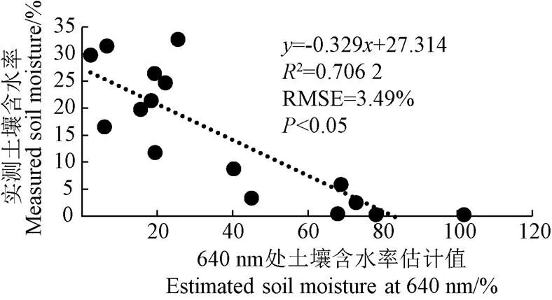
图4 640 nm处土壤含水率估计值与真实值之间的拟合曲线
3 结 论
本文介绍了一种基于辐射传输理论的土壤含水率遥感估算方法,并得到以下结论:
1)土壤水分会增加其对辐射能量的吸收,使土壤反射光谱整体降低,并且在1 400和1 900 nm呈现2个明显的吸收峰,吸收峰的深度与土壤含水量高度相关。试验控制的光谱测量数据可以较好的描述土壤水分对土壤反射光谱的影响,同时尽可能的降低其他土壤因素对反射光谱的影响,降低分析难度。
2)通过试验数据拟合得到指数模型参数()可以描述土壤水分对辐射能量的逐波段衰减特征,并且()与纯水的吸收系数具有高度的一致性。
3)利用本文光谱分析法的土壤含水率遥感估算模型可以实现土壤含水率的定量监测。在640 nm处土壤含水率的估计值与真实值之间的决定系数为0.706 2,RMSE为3.49%。
本研究仅考虑了土壤水分对反射光谱的影响,至于土壤有机质、土壤团粒结构、以及土壤覆盖物对光谱的影响有待进一步研究。此外,本文所用数据都是基于室内试验获得,构建模型尚停留在实验室阶段,结合野外的光谱影像的土壤含水率反演研究有待进一步展开。
[1] 李笑吟,毕华兴,刁锐民,等. TRIME-TDR土壤水分测定系统的原理及其在黄土高原土壤水分监测中的应用[J]. 中国水土保持科学,2005,3(1):112-115.
Li Xiaoyin, Bi Huaxing, Diao Ruimin, et al. The measurement principles of TRIME-TDR system and its application in Caijiachuan watershed of Loess Plateau China[J]. Science of Soil and Water Conservation, 2005, 3(1): 112-115. (in Chinese with English abstract)
[2] 李明泽,高元科,邸雪颖,等. 基于微波遥感技术探测森林地表土壤含水率[J]. 应用生态学报,2016,27(3):785-793.
Li Mingze, Gao Yuanke, Di Xueying, et al. Detecting the moisture content of forest surface soil based on the microwave remote sensing technology[J]. Chinese Journal of Applied Ecology, 2016, 27(3): 785-793. (in Chinese with English abstract)
[3] 刘伟东, Frédéric Baret,张兵,等. 高光谱遥感土壤湿度信息提取研究[J]. 土壤学报,2004,41(5):700-706.
Liu Weidong, Frédéric Baret, Zhang Bing, et al. Extraction of soil moisture information by hyper-spectral remote sensing[J]. Acta Pedologica Sinica, 2004, 41(5): 700-706. (in Chinese with English abstract)
[4] 裴承忠,彭翔,曾文治,等. 盐渍条件下土壤含水率高光谱反演研究[J]. 中国农村水利水电,2016(8):73-75.
Pei Chengzhong, Peng Xiang, Zeng Wenzhi, et al. Estimation of soil moisture from hyper-spectral in saline soil[J]. China Rural Water and Hydropower, 2016(8): 73-75. (in Chinese with English abstract)
[5] 王全九,王文焰. 盐碱地膜下滴灌技术参数的确定[J]. 农业工程学报,2001,17(2):47-50.
Wang Quanjiu, Wang Wenyan. Determination of technique parameters for saline-alkali soil through drip irrigation under film[J]. Transactions of the Chinese Society of Agricultural Engineering (Transactions of CSAE), 2001, 17(2): 47-50. (in Chinese with English abstract)
[6] 刘云,宇振荣,孙丹峰,等. 冬小麦冠层表面温度裂窗算法的筛选与土壤含水率监测[J]. 农业工程学报,2006,22(11):16-21.
Liu Yun, Yu Zhenrong, Sun Danfeng, et al. Selecting split-window algorithm for retrieving canopy surface temperature of winter wheat and monitoring soil water content[J]. Transactions of the Chinese Society of Agricultural Engineering (Transactions of CSAE), 2006, 22(11): 16-21. (in Chinese with English abstract)
[7] 张学礼,胡振琪,初士立. 土壤含水量测定方法研究进展[J]. 土壤通报,2005,36(1):118-123.
Zhang Xueli, Hu Zhenqi, Chu Shili. Methods for measuring soil water content: A review[J]. Chinese Journal of Soil Science, 2005, 36(1): 118-123. (in Chinese with English abstract)
[8] 郝改瑞,李智录,李抗彬. 区域土壤含水率遥感监测分析方法研究进展[J]. 水利与建筑工程学报,2012,10(4):139-144.
Hao Gairui, Li Zhilu , Li Kangbin. Progress of monitoring and analysis for regional soil water content through remote sensing[J]. Journal of Water Resources and Architectural Engineering, 2012, 10(4): 139-144. (in Chinese with English abstract)
[9] Nanni M R, Demattê J. Spectral reflectance methodology in comparison to traditional soil analysis[J]. Soil Science Society of America Journal, 2006, 70(2): 393-407.
[10] D'Urso G, Minacapilli M. A semi-empirical approach for surface soil water content estimation from radar data without a-priori information on surface roughness[J]. Journal of Hydrology, 2006, 321(1/2/3/4): 297-310.
[11] Wang Q, Li P, Pu Z, et al. Calibration and validation of salt-resistant hyper-spectral indices for estimating soil moisture in arid land[J]. Journal of Hydrology, 2011, 408(3/4): 276-285.
[12] Yang X, Yu Y. Estimating soil salinity under various moisture conditions: An experimental study[J]. IEEE Transactions on Geoscience & Remote Sensing, 2017, 55(5): 2525-2533.
[13] Hassan-Esfahani L, Torres-Rua A, Jensen A, et al. Assessment of surface soil moisture using high-resolution multi-spectral imagery and artificial neural networks[J]. Remote Sensing, 2015, 7(3): 2627-2646.
[14] Mirzaee S, Ghorbani-Dashtaki S, Mohammadi J, et al. Spatial variability of soil organic matter using remote sensing data[J]. Catena, 2016, 145: 118-127.
[15] Yang Hongfei, Qian Yurong, Yang Feng, et al. Using wavelet transform of hyperspectral reflectance data for extracting spectral features of soil organic carbon and nitrogen[J]. Soil Science, 2012, 177(11): 674-681.
[16] Nocita M, Stevens A, Noon C, et al. Prediction of soil organic carbon for different levels of soil moisture using Vis-NIR spectroscopy[J]. Geoderma, 2013, 199: 37-42.
[17] Guo Q. Correlation between soil apparent electro- conductivity and plant hyper-spectral reflectance in a managed wetland[J]. International Journal of Remote Sensing, 2011, 32(9): 2563-2579.
[18] Yin Z, Lei T, Yan Q, et al. A near-infrared reflectance sensor for soil surface moisture measurement[J]. Computers & Electronics in Agriculture, 2013, 99: 101-107.
[19] Nolet C, Poortinga A, Roosjen P, et al. Measuring and modeling the effect of surface moisture on the spectral reflectance of coastal beach sand[J]. Plos One, 2014, 9(11): e112151.
[20] Liu W D, Baret F, Gu X F, et al. Relating soil surface moisture to reflectance[J]. Remote Sensing of Environment, 2002, 81(2): 238-246.
[21] Rijal S, Zhang X, Jia X. Estimating surface soil water content in the red river valley of the north using Landsat 5 TM data[J]. Soil Science Society of America Journal, 2013, 77(4): 1133.
[22] Zhang T. Estimation of agricultural soil properties with imaging and laboratory spectroscopy[J]. Journal of Applied Remote Sensing, 2013, 7(1): 073587-073587.
[23] 刁万英,刘刚,胡克林. 基于高光谱特征与人工神经网络模型对土壤含水量估算[J]. 光谱学与光谱分析,2017,37(3):841-846.
Diao Wanying, Liu Gang, Hu Kelin. Estimation of soil water content based on hyper-spectral features and the ANN model[J]. Spectroscopy and Spectral Analysis, 2017, 37(3): 841-846. (in Chinese with English abstract)
[24] 史舟. 土壤地面高光谱遥感原理与方法[M]. 北京:科学出版社,2014.
[25] Demattê J A M, Nanni M R, da Silva A P, et al. Soil density evaluated by spectral reflectance as an evidence of compaction effects[J]. International Journal of Remote Sensing, 2010, 31(2): 403-422.
[26] Leng P, Song X, Li Z L, et al. Toward the estimation of surface soil moisture content using geostationary satellite data over sparsely vegetated area[J]. Remote Sensing, 2015, 7(4): 4112-4138.
[27] 陈立新. 土壤实验实习教程[M]. 哈尔滨:东北林业大学出版社,2005.
[28] Baumgardner M F, Silva L R F, Biehl L L, et al. Reflectance properties of soils[J]. Advances in Agronomy, 1985, 38: 1-44.
[29] 程街亮,纪文君,周银,等. 土壤二向反射特性及水分含量对其影响研究[J]. 土壤学报,2011,48(2):255-262.
Cheng Jieliang, Ji Wenjun, Zhou yin, et al. Soil Bidirectional reflectance characteristics as affected by soil moisture[J]. Acta Pedologica Sinica, 2011, 48(2): 255-262. (in Chinese with English abstract)
[30] Muller E, Décamps H. Modeling soil moisture-reflectance[J]. Remote Sensing of Environment, 2001, 76(2): 173-180.
[31] Hale G M, Querry M R. Optical constants of water in the 200-nm to 200-μm wavelength region[J]. Applied Optics, 1973, 12(3): 555.
杨曦光,于 颖. 基于试验反射光谱数据的土壤含水率遥感反演[J]. 农业工程学报,2017,33(22):195-199. doi:10.11975/j.issn.1002-6819.2017.22.025 http://www.tcsae.org
Yang Xiguang, Yu Ying. Remote sensing inversion of soil moisture based on laboratory spectral reflectance data[J]. Transactions of the Chinese Society of Agricultural Engineering (Transactions of the CSAE), 2017, 33(22): 195-199. (in Chinese with English abstract) doi:10.11975/j.issn.1002-6819.2017.22.025 http://www.tcsae.org
Remote sensing inversion of soil moisture based on laboratory reflectance spectral data
Yang Xiguang1, Yu Ying2※
(1.()(),150040,; 2.,,150040,)
Soil moisture is one of the important components of soil and plays an important role in the material and vegetative nutrient transport process in the soil system. Soil moisture is also an essential soil physical parameter in the study on water cycle in ecological system, and a key variable of drought monitoring, soil erosion and surface evaporation studying. Therefore, soil moisture monitoring is very important. Remote sensing technology has been applied to soil moisture monitoring with its advantage of high efficiency and rapidness. The soil hyper-spectral ground experiment and the soil hyper-spectral characteristics are the basis for the inversion of soil moisture. In this paper, soil samples collected in field were mixed to achieve the purpose of keeping approximately constant soil properties. Then mixed soil sample was divided into 16 independent samples in order to ensure that the effects of soil properties on reflectance of each soil sample were at the same level, such as soil organic matter, soil texture, and soil salinity. After that, the samples were slowly irrigated with distilled water to get different levels of moisture. And the spectral data of each sample were measured at the same time under laboratory conditions. Based on this dataset, a remote sensing inversion model of soil moisture content based on exponential function was established and the parameters of model were fitted by using the experimental spectrum data. Fitted parameters illustrated the effects of soil moisture on soil reflected energy at each single band from 350 to 2 500 nm. A larger value of the fitted parameter indicated that more energy was absorbed by water and less energy was reflected. Result showed that there were 2 peaks near 1 400 and 1 900 nm after a steady trend less than 1 300 nm. And this fitted result was consistent with the absorption coefficients of pure water. It indicates that the exponential model with physically definable parameters can be used to describe the characteristics of soil reflectance changing with soil moisture conditions. Then this inversion model was used to estimate the soil moisture based on laboratory spectral data. The accuracy varied with soil moisture level, and it was lower for samples with soil moisture larger than 32.75% and lower than 5.52%. When soil moisture was 32.75%, the maximum absolute error and the minimum absolute error were 134.89% and 25.44%, respectively. When soil moisture was equal and lower than 5.52%, the maximum absolute error was larger than 200%. The estimation accuracy was better when the soil moisture was between 5.52% and 32.75%. The mean absolute error was less than 30% and the maximum absolute error was 83.81%. The determination coefficient and RMSE (root mean square error) between estimated and measured soil moisture content at 640 nm were 0.706 2 and 3.49%, respectively. The results indicate that the inversion model based on the exponential function can be used for soil moisture content estimation with good accuracy. This work provides new methods and ideas for monitoring topsoil moisture content by using remote sensing technology.
soil moisture; remote sensing; models; exponential function; inversion model; hyperspectral remote sensing
10.11975/j.issn.1002-6819.2017.22.025
TP79; S15
A
1002-6819(2017)-22-0195-05
2017-06-05
2017-11-07
国家自然科学基金(31500519,31500518);中央高校基本科研业务费(2572017BA06)。
杨曦光,男,黑龙江省哈尔滨人,博士,讲师,主要从事高光谱遥感原理及反演方法研究。Email:yangxiguang21@163.com
于 颖,女,辽宁省大连人,博士,副教授,主要从事定量遥感及GIS研究。Email:yuying4458@163.com
猜你喜欢
农业工程学报(2022年5期)2022-06-22
北方人(2018年16期)2018-08-20
智能计算机与应用(2017年5期)2017-11-08
南水北调与水利科技(2017年4期)2017-07-29
中国水土保持科学(2017年1期)2017-04-18
爱你(2016年4期)2016-12-06
中国测试(2016年3期)2016-10-17
自然资源遥感(2014年2期)2014-02-27
自然资源遥感(2014年2期)2014-02-27
时代青年(上半月)(2009年2期)2009-08-11
