
基于森林景观恢复策略的庄园遗产景观设计探寻——以荷兰海德兰省巴克塞比克地区为例
2021-08-03 03:04王颜姣斯特芬奈豪斯鲍勃乌尔森
风景园林 2021年7期
王颜姣 (荷)斯特芬·奈豪斯* (荷)鲍勃·乌尔森
1 前言
庄园遗产景观(heritage estate landscape)由历史乡村庄园集群构成,表现了历史进程中人文活动规律及人与自然环境的互动(图1)。庄园遗产景观既给人们带来视觉享受,也揭示了当地蕴含的文化背景,对促进区域发展的新陈代谢起到重要作用。然而,随着工业化与急剧的城市化,遗产景观面临着气候变化与文化特色丧失的威胁[1]。如今,人为干预、气候变化、洪涝与干旱以及土壤功能丧失破坏了生态环境平衡。同时,多元化景观也因景观均质化、景观元素消失和空间格局碎片化带来的负面影响而退化为单一功能的工业化农业景观。生态多样性的缺失与水土保持能力的下降给景观的修复与管理带来严峻挑战。它们不仅影响了庄园遗产景观,也给区域景观系统带来压力。为应对挑战以及保护、恢复和进一步发展宝贵的文化历史景观,引入多尺度的空间规划与设计方法,并结合研究场地的景观特性对庄园遗产景观进行进一步探讨。

1 庄园遗址景观的历史情况与现状Typical scene of a heritage estate landscape in history and now
为营建能够积极应对未来挑战的庄园遗产景观,基于对景观系统性构架的理解,生态视角下的多尺度规划设计将是一个直接有效的方法[2]。它不仅能够保护与发展生态价值与社会经济价值,还能促进小尺度层面各景观元素的积极互动[3]。利益相关者在区域构架内多个层面的沟通也将通过研究、设计、讨论与想法的可视化等过程得到加强[4]。
本研究选择荷兰海德兰省巴克塞比克地区的庄园遗产景观和庄园遗产景观区内的梅德勒和维斯2个庄园单体,从2个尺度进行研究型设计,旨在强调一种适应性的多尺度景观设计方法。对本研究的研究对象而言,森林被理解为该庄园遗产景观特性的主要元素,而森林砍伐被理解为导致区域空间格局变化、引发水系统问题以及生物多样性缺失的重要因素[5]。基于此,森林景观恢复(forest landscape restoration, FLR)作用为一种顺应景观自然发展规律的设计策略被引用到不同尺度的退化景观中,以提升生态功能与人类福祉。本研究中,FLR为基于景观的区域规划设计提供了可能性,景观设计作为解决区域问题和提升空间质量与社会价值的有效方法,为庄园遗产景观面对来自当下与未来的挑战提供指导。
2 森林景观恢复作为多尺度景观设计策略
FLR的概念由Chazdon等[6]提出并逐渐发展,是指恢复森林砍伐后或退化的景观的生态功能并提升人类福祉的过程。FLR的提出应基于以下6点原则[7]:1)着眼于景观发展;2)通过景观维护提升自然生态系统;3)促进利益相关者与政府协调方的交流与互动;4)基于实际情况使用多种方法;5)以多元化价值为目的的功能多样性恢复;6)因地制宜式的、具有可持续性韧性的管理措施。
森林景观恢复一方面注重种树的合理性,另一方面也旨在解决社会需求与提升人类福祉。森林景观恢复的不同策略也已通过多个实际项目在全球范围内得到实践,例如泰国的都市森林项目[8]、埃因霍温的湿地森林[9]、荷兰高费吕韦国家公园[10]、英国新森林国家公园[11]、德国博肯纳天堂自然保护区[12]、墨西哥清风造林项目[13]等。然而,森林景观恢复目前几乎还未被融入基于景观的区域尺度规划设计的框架中。通过设计进行研究是探索景观可能性和确定应对方案的方法之一,该方法可以探索设计原则应用的可能性[14]。通过这种研究和设计机制,可以揭示区域研究的相关信息,从多个方面探索景观的发展潜力,整合动态环境与人类活动的联系与发展愿景。对设计的影响价值进行反思,发现“通过设计进行研究”是一种获取关于景观特征、空间发展可能性和解决实际挑战的实用方法。
本研究案例中,FLR作为多尺度景观设计策略,通过建立乡村庄园单体之间的系统性联系,利用本土历史与传统生态智慧,合理应用旨在对生态、可识别景观、农业3个方面提升生态与文化价值的设计原则,对环境与空间格局进行积极干预。在研究与设计过程中,FLR不仅被用来指导优化树木群落种植,同时也促使景观向应对当下和未来挑战的方向发展。在将长远目标与短期干预措施相结合的过程中,FLR能为微观尺度与区域尺度上的景观提供优质生境与生态功能(图2)。FLR在本研究案例中的愿景有:1)优质生态环境;2)可识别景观;3)多样化用地类型;4)多方合作;5)可持续发展。

2 森林景观恢复框架——庄园遗产景观开发与保护的多尺度景观设计方法Forest Landscape Restoration (FLR) framework as multiscale landscape design strategy in heritage estate landscape development and protection
FLR作为系统性方法,被应用于巴克塞比克地区的庄园集群、梅德勒和维斯庄园联合体、庄园单体等多个尺度的景观中,促进了跨尺度景观间的相互作用。在区域尺度上,FLR促进了庄园遗产景观空间质量的提升。针对不同的情境,提出对应的设计原则和空间干预措施来解决特定场地的问题。例如,重新引入和演绎历史及相应景观要素,构筑能提高景观质量的新景观元素,打造智慧农场,进行恢复性造林、补充性造林以及加强土地利用。针对微观尺度的具体情况,介绍了基于设计策略和原则的具体措施方法。为改善生态环境,修复历史景观,在适合的地方重建历史溪流和沟壑林;在地势较高且干燥的地区,提出了将传统森林景观类型整合到景观中的发展策略,使森林草甸、篱笆林、分林等群落形态融于森林公园景观;为提升水质,在小溪河岸带建设森林和人工湿地;通过引入观景点、栈道、重要节点的科普标识,合理梳理道路和河流交叉口的关系。庄园遗产景观的可达性和游客的空间体验感得到提升。
3 庄园遗产景观——以巴克塞比克地区为例
3.1 巴克塞比克地区
巴克塞比克位于荷兰东部的阿赫特虎克片区,隶属于海德兰省的沙质景观区,是一条从东向西流淌的溪流(图3)。这条溪流在通往艾瑟尔河的途中,会经过多种类型的景观,如东部洪泛景观(缓流溪流区)、庄园遗产景观(低地溪流区)、沙脊景观(临时溪流区)、石南景观(石南溪流区)、“坎彭”景观(湿地溪流区)和台地边缘景观(台地溪流区)。各区域有着独特的景观要素、地理和生态条件,构成了该流域丰富的景观类型(图4)。遍布巴克塞比克流域的庄园中的别墅与周边自然景观融为一体,使该地区景观富有浓厚的历史人文色彩[15]。
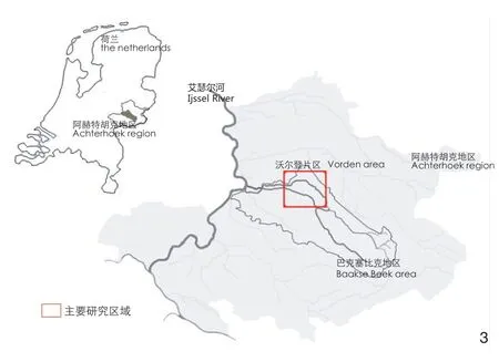
3 巴克塞比克地区区位图The Baakse Beek Region in the Netherlands

4 巴克塞比克地区的6种景观形态[15]Six landscape typologies in the watershed of the Baakse Beek Region[15]
然而,该区域景观因均质化发展正面临挑战,其主要原因是人类活动和气候变化给环境造成了不利影响,使土地很难为人、农作物和动物提供适宜生活与生存的条件。在庄园区的发展历程中,除了巴克塞比克溪流和庄园本身,森林景观从历史到现在也对该地区产生了重要影响。森林作为庄园遗产景观特征的重要组成部分,也是联系生态和社会文化的纽带。
在末次冰期(约1万年以前),该地区的原有植被主要为沼泽与物种丰富的落叶林,15%的地区被泥炭覆盖,是对动植物和人文活动都具有较高价值的地区。大约2 000年前,人们沿着溪流进入该地区,开垦农田、渠化河道并砍伐大量树木获取木材。18世纪中叶,在工业革命开始之前,随着人类活动对自然景观的毁坏加剧,荷兰东部古老森林也因过度开发而消失。17—18世纪,巴克塞比克溪流中段出现了乡村庄园,形成了该地区早期的庄园遗产景观。同时,一系列文化运动及其引发的现象,包括启蒙运动、人口膨胀、土地改革、世界大战、工业革命和农业革命等,推动了城市化进程,使得对运河网络、航运系统和木材的需求与日俱增。除此之外,更多的自然用地被开发以用于农田扩张和速生树种植。伐木不仅降低了森林覆盖率,而且对人们的农业活动和生活环境也有负面影响。19世纪末,在革命时代景观与后现代新景观的过渡时期,环境保护逐渐引起人们的重视。为抑制森林减少的趋势,小型组织开始成立,如荷兰自然古迹保护协会(荷兰语:Vereniging tot Behoud van Natuurmonumenten)。政府也制定了相关条例以促进造林,既为保护生态系统,也旨在发展木材产业、促进经济。“二战”后,景观逐渐进入后现代新景观时代。如此,当前的景观是集合了不同发展阶段、显示了人们的景观态度的复合景观[16]。
3.2 设计挑战
庄园区的历史发展体现了森林景观的重要性。然而,近几十年来,庄园遗产景观的森林遭受严重的破坏,面临水文环境、气候变化和景观特征3方面的问题。
3.2.1 庄园遗产景观与水文环境
受森林砍伐的影响,庄园区的自然植被和作物的生长环境干旱且所处的水生态系统十分脆弱。考虑到土壤功能的退化,以及泥炭在经过历史上的开垦活动之后几乎消失,如今土壤的蓄水能力逐渐下降,且土壤类型多为缺乏养分的沙质土壤,人们很难有效利用土地。
3.2.2 庄园遗产景观与气候变化
气温升高是气候变化最重要的表现形式之一,对该地区产生了重大影响。根据STOWA[17],与1990年相比,2050年荷兰的夏季平均气温将上升1~2 ℃。近年来的夏季干旱带来的缺水问题已成为自然保护主义者、农民和业主必须应对的挑战。冬天,丰富的降水也导致该地区洪水泛滥。同时,由于庄园区位于巴克赛比克溪流的中游地段,农业产量和景观质量也会因此下降[18]。
3.2.3 庄园遗产景观与景观特征
多样化的微地形是巴克塞比克地区的重要景观特征。这些小幅度的高差变化也带来了多样的景观类型[19]。本研究对象为位于低地溪流区的庄园遗产景观,包含了丰富的自然和文化资源。庄园遗产景观面临的挑战包括可达性低、文化历史景观体验缺失、利益相关者之间缺乏沟通以及地貌条件与自然类型之间的不合理联系(图5)。上述问题也造成了庄园遗产景观场地精神与历史记忆表达不足。

5 地质地貌条件与原生森林群落[20]Geomorphology condition and their natural forest[20]
目前,巴克塞比克地区的庄园遗产景观正面临着生态和景观质量2方面的挑战。与此同时,庄园区也为设计师提供了平衡生态环境、农业活动和基于景观的空间质量的机会。
3.3 森林景观恢复在规划与设计中的应用
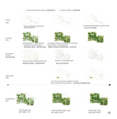
为应对上述挑战,设计应用FLR作为保护和发展生态环境、恢复文化遗产和增进人类福祉的设计策略。基于FLR策略框架[21],整合多个关键干预措施,为庄园区构建了规划愿景。例如:恢复性造林、补充性造林、营林生产、农林复合、改良休耕和一些不同形式的干预措施。这些措施将共同塑造更具韧性的生态环境,并使人们的福祉得到改善。该框架在当前土地利用类型和相应的FLR策略之间建立了联系。例如,目前的沼泽地是林地的一部分,没有树木覆盖。根据该框架,将在这些沼泽地引入恢复性造林与补充性造林(图6)。

6 森林景观恢复框架(6-1)及其在区域尺度上的应用(6-2)[21]FLR framework (6-1) and its application at the regional scale (6-2)[21]
3.3.1 区域性框架的建立
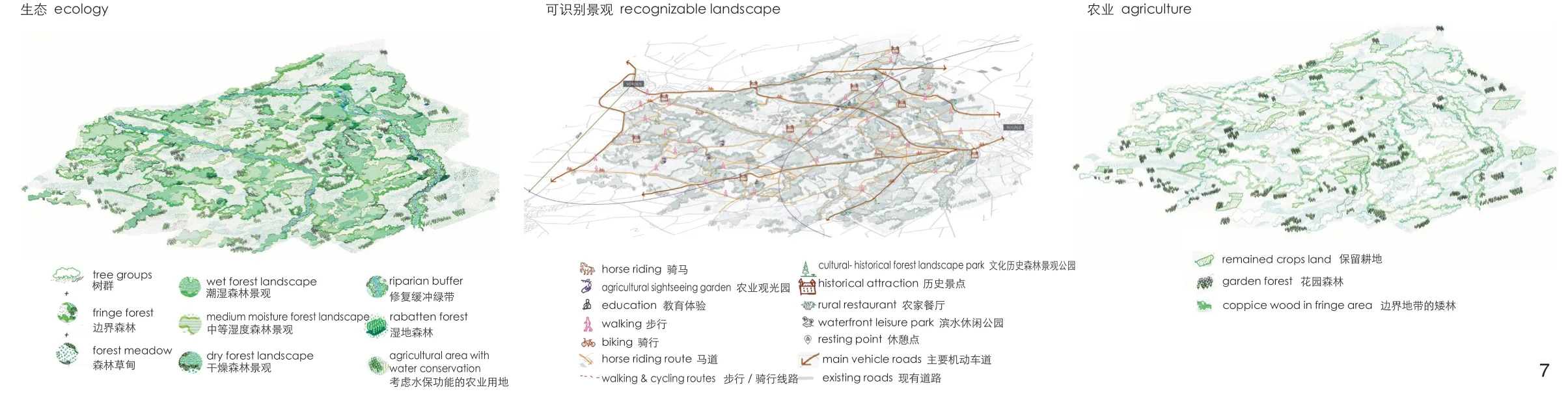
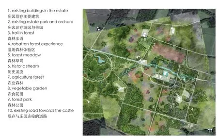
FLR作为设计策略,将包含11个庄园单体及其附属农场、建成区和自然片区在内的庄园遗产景观元素整合为全面的区域性景观规划框架。该框架主要包含了生态、可识别景观与农业3个方面的措施与方针(图7)。
7 适应性森林景观恢复框架的3个层面Three layers of the adaptive FLR framework
3.3.1.1 生态
基于该地区的地貌条件以及自然萌发的潜在植被作为发展基础,提出了FLR框架下的生态层面策略。根据植被的生长习性,不同的森林群落被合理规划到符合相应生长条件的区域。在低洼潮湿地区,规划设计适宜在该生境下生长的、由原生树木和其他植物多层次组合的植物群落。对于干旱和中度干旱地区,可以发展栎–山毛榉群落和桦–栎群落,并利用自然演替规律保证其持续性;对于较为湿润的地区,桤–白蜡群落和湿地桤木群落则作为主要的森林群落被引入。因地制宜地规划设计森林群落,有助于创造各种有价值的栖息地,从而提高该地区的生态效益,促进作为“绿色基础设施”的新景观提高该地区的蓄水能力、水土保持能力和生物多样性。
此外,FLR也能促进庄园遗产景观中的水文循环。基于自然网络中丰富的物种和群落层次,景观与水系统的关系更加紧密。结合下层的树木和植被在水文循环系统中的重要作用,降水量增加时,落叶乔木也可以有效阻止水分蒸发[22],土壤水分也可以在地下得到积累和保持。同时,落叶残余和溶解性有机物的渗漏有助于增加土壤矿物质。
充分利用树木生态价值能促进景观质量的提升。树木的蒸腾作用和其他生理功能驱动自然环境(特别是水文环境)中关键的水分循环和碳氮循环,合理的植被密度也有助于保证溪流中水质达标,从而为游客提供美丽的景色。基于农业用地的FLR,通过选择阔叶树种和适宜的农作物减少水分流失、积累土壤矿物质,从而促进水文循环。
因为庄园区现有的森林区域的规划侧重考虑其经济价值,缺乏对植被适应和自然系统保护的关注,所以现存森林群落构成仍需进一步调整。从景观发展史的第二阶段(革命时代景观)开始,原有的森林群落就已逐渐被生产林和农田所取代。物种多样性的缺失不但影响了生态多样性,同时也影响着水文环境;气候变化也逐渐改变了森林群落的组成、功能、生产力和生境,并影响着生态系统的平衡[23]。而这些原始森林群落中存在的丰富物种,经历长期繁衍、适应生境后,往往能在不同层次上通过持续的合作为生境带来持续的积极影响。基于此,恢复物种多样性后的庄园遗产景观将促进景观与生态环境形成更紧密的联系,同时增强人们与自然的互动。通过合理规划森林群落类型,新庄园遗产景观可以向游客展现景观的历史故事,并更好地提供场地感观体验。在沃尔登片区的森林景观恢复工作建设完成后,绿色基础设施将发展成为具有更大生态调控能力的顶级森林,从而进一步促进稳定、有弹性的生态系统的发展。
3.3.1.2 可识别景观
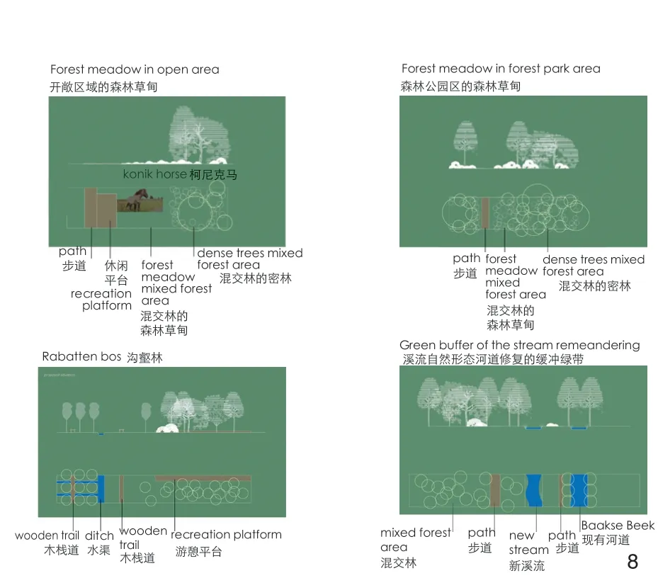
可识别景观是具有明显空间特性和景观特征,并能让游客感知当地历史的景观。基于自然景观特征,开发新的体验路线和科普娱乐目的地,从而加强历史森林景观与现代庄园遗产景观的联系。利用森林资源研究发展具有独特空间特征的森林类型,使庄园遗产景观的历史层面更加清晰,并为人们提供多样化和有意义的空间体验(图8、9)。
8 巴克塞比克地区的4种历史森林形态Four historical forest types in the context of the Baakse Beek Region
9 FLR作为提升空间景观形态的策略FLR as a means to develop spatial landscape typologies
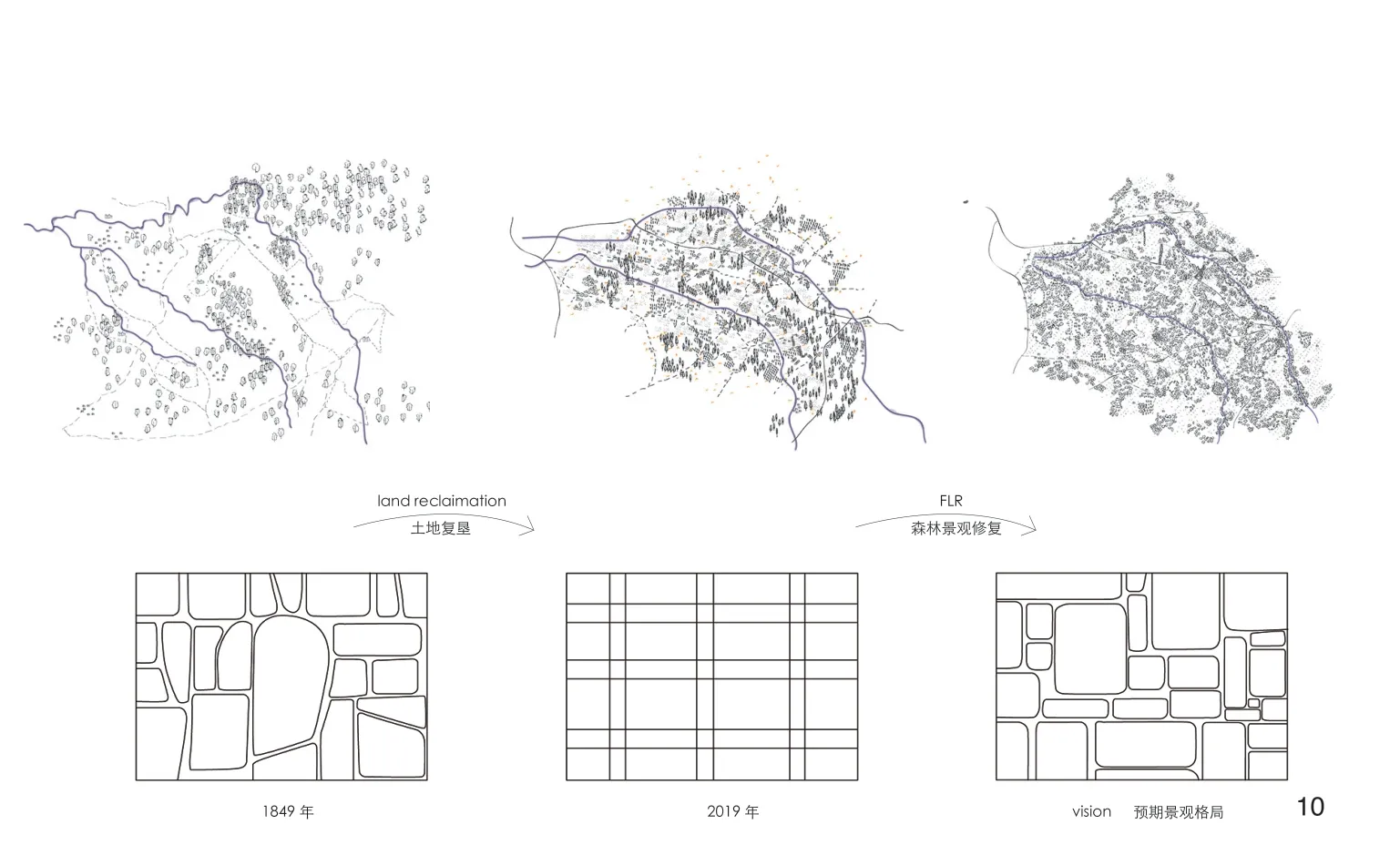
此外,历史森林类型的修复有助于发展历史景观的空间格局(图10)。受历史上的土地复垦的影响,以及对生态环境和未来发展的考虑的缺少,人们很难从目前的网格状空间格局和同质化景观中了解庄园背后的故事。通过FLR的介入,历史空间格局的有机形态得以恢复,且更具韧性与表达性。

10 区域尺度上空间格局的恢复Restoring the spatial pattern at the regional scale
通过森林景观恢复,加强庄园周围的景观与内部独具特色的花园建筑的视觉联系,从而揭示各庄园历代关于自然和文化的故事。另外,乡村别墅的花园与周围森林和农田等用地内的新景观元素,如果树、牛和农舍等,相互渗透、过渡并融于庄园遗产景观中,这也体现了与中国园林建筑中相似的“借景”原则。
基于生态层面的策略,历史森林景观的恢复可以突出森林景观类型与景观体验的联系。通过恢复与更新森林景观,合理规划不同活动场景下的树木群落,使庄园遗产景观的特性可以以更直观的方式被呈现。
3.3.1.3 农业
基于与新的绿色基础设施合作的设计策略,农业方面的干预策略以农林结合为主要形式、作用于目前碎片化的农业用地,持续地丰富农业活动类型。目前农业用地是该区域的主要用地类型,这也使得农业具有巨大的发展潜力,并进一步推动农业发展、使其智能化。考虑到农业区通常排布有排水沟和灌溉沟,循环垂直的人工湿地在菜园区的应用则具有一定的潜力。这项技术不仅可以改善水质,减少卫生问题,还可以提高作物产量[24]。另外,该技术也有助于农业区发展成为游客互动与农产品生产相结合的平台。花园还包含不同的蔬果种植模式,以便更好地利用有限的土地、土壤营养和阳光[25]。例如种植结构下层是浆果灌木和多年生草本植物,主要用于季节性生产和农家采摘活动,使区域获得更大的经济效益和社会效益。对于保留的耕地,智能管理和监测是必要环节。耕地内主要作物种类多为阔叶树种,如玉米,配合小乔木或树篱种植,以促进养分和水分循环,有利于提高产量。考虑到木材生产是该地区的主要生产活动之一,且有较大的发展机遇,FLR策略中的矮林将作为可持续生产林的新形式在这里进行引用并发挥潜力。
在农业方面,设计结合农耕活动,灰柳(Salix cinerea)、黑橡树(Quercus velutina)、欧榛(Corylus avellana)等饲用树种拟在森林边缘区种植,根据种植日历合理规划农业活动,为游客提供更多通过农业感知景观的新视角,以维护市场需求,同时保障农民利益。花园森林不仅可以作为游客的休闲目的地,为他们提供食品,还可以支持当地遗产保护项目:“高秆水果方舟”(Achterhoek):通过在花园森林中种植当地特定品种的苹果树,以保护该地区的特殊遗产。参照《高秆果树手册》,7种苹果树①将在研究区进行引种。
通过运用FLR,农业区不仅用于生产,也是人们休闲娱乐的可食景观体验区。设计将农产品、农场与娱乐活动相结合,缩小农民、当地食品和人们之间的距离,同时也吸引了更多的游客前来参观。在此之前,消费者至少需要4个步骤才能购买到产品,而且由于耗时较长,食品的新鲜度会受到影响。然而,FLR策略下的农林复合经营策略和营销模式使得农产品交易过程既省时又具有娱乐性。
3.3.2 在地尺度上的设计探索
在区域尺度上基于FLR的战略规划中,在地尺度的庄园遗产景观的具体设计任务得到了进一步确定与阐述,并从生态、可识别景观和农业3个角度应对各自的挑战,为庄园增添价值。
维斯庄园(荷兰语:De Wiersse)及其游园和花园是一个以传统风格来设计并与周围景观紧密融合的集合体。庄园选址靠近水源,同时片区内包含多样化的土地用途,例如牧场与农产品种植等。庄园中也富含包括森林(例如沟壑林,Rabatten)、景观视线,房屋和雕像等在内的历史遗留的景观元素。但是,水质水量的不足给如今的庄园带来巨大挑战,同时对原始的栖息地与自然环境产生很大的影响。
在FLR框架下,干预措施以营林、农林业和补充性造林3种形式为主,旨在共同促进生态环境和空间体验的发展。在维斯庄园的新景观中,历史悠久的溪流和河道可通过新的河岸缓冲区和巴克塞比克地区沿岸的植物群落来过滤和调节土壤的蓄水能力并提高水质(图11);“沟壑林”和“森林草甸”等历史森林景观的恢复可以促进该庄园现有森林和营林的发展(图12)。树木不仅能调控二氧化碳的循环,而且可以提升该地区的“海绵”能力。此外,它还促进人们与历史森林景观的共鸣,加强人们对区域特性的辨识度。通过在庄园列植树木,强调轴线,从而形成具有视觉价值的景象。功能单一和工业化的农业用地通过合理引入当地果树品种、马匹等转变为多功能的森林花园。通过应用农林业结合的市场模式,促进生物多样性以及游客与景观的互动。因此,森林景观恢复的森林密度与组成类型的多样性有助于加强庄园的生态和社会价值。这也将对位于维斯庄园下游的其他庄园(如梅德勒庄园)的景观产生积极影响。
11 FLR干预下的维斯庄园FLR at De Wiersse

12 沟壑林作为造林干预维斯庄园的一种形式(12-1)以及沟壑林的后期管理(12-2)[26]“Rabatten” forest as a tool of silviculture at De Wiersse(12-1) and its management (12-2)[26]
梅德勒庄园(荷兰语:Het Medler)的主体建筑被护城河环绕,所处地势较高,其附属的农场和储藏室则位于较低的位置。基于庄园内多次的土地交换历史,庄园区内的农舍具有深厚的文化底蕴,整个庄园与若干农舍点缀组合而成的独特景观也使得景观体验感更加丰富。但是,由于沟渠干涸、天然林工业化带来的物种多样性缺失、庄园和草甸的低可达性,庄园遗产景观的复原力正面临挑战。此外,庄园内农业活动的增加也不断损害着植被的多样性,并导致庄园遗产景观的均质化。在梅德勒庄园采用农林业结合的方式,与农民共同决策土地的多样化合理使用,推动历史悠久的农舍融于景观,引导游客感知该地区的文化历史(图13)。此外,这些干预措施也为生态环境带来了好处。因地制宜地对本土物种和植物群落进行规划,依靠自然植被的生长过程逐渐解决水质水量的问题。此外,通过加强物理和视觉的联系,使得梅德勒庄园与维斯庄园等周边景观的联系进一步加深(图14)。

13 FLR干预下的梅德勒庄园FLR at Het Medler

14 在地尺度上空间格局的发展The development of spatial patterns at the local scale
因此,FLR的设计策略也具有解决微观尺度上庄园个体所面临的个别问题的能力。同时,通过在各个庄园遗产景观单体之间建立空间联系,为整个区域提供了可以产生更多积极效应的可能性。
4 结论与讨论
4.1 庄园遗产景观设计的重要性
庄园遗产景观是社会因素与生态环境紧密联系的复合体。开发和保护此类景观可以为地区带来重要的社会和生态价值。例如,通过提升可达性和景观质量,改善水环境质量,并配置能有效适应环境的各种森林群落等设计策略,促进旅游和娱乐、增加生物多样性。除此之外,人类福祉也能通过宜人的自然环境得到促进。考虑到庄园内农业活动会密切影响经济状况,因此景观的长远发展应在规划和设计中着重考虑,以确保各利益相关者的利益。特别是在面对与土地所有权和土地管理机制相关的复杂情况时,只有通过多方有效沟通才能解决问题。因此,在协作过程中应注重有效设计方法的必要性,以增加相互了解,共同制定方案,周全考虑自然和人类之间的平衡关系。
同时,庄园遗产景观的规划设计过程揭示了基于景观的区域韧性发展的广泛可能性。不仅限于打造水敏感和生态良好的环境,而且为景观文化元素的修复提供机会,增强空间体验、丰富空间特性。
4.2 FLR作为设计策略在庄园遗产景观的应用
区域景观设计方法对于多学科合作至关重要,它能有效从区域和地方尺度上将生态、休闲和社会系统的新陈代谢等方面整合到空间发展。在巴克塞比克地区,市政、设计师和其他利益相关者正在采用这种方法来实现具有气候韧性的庄园遗产景观。本研究将FLR理解为适用于多尺度的潜在设计策略,并对其进行多视角的讨论。
在本研究案例中,FLR为庄园遗产景观提供了韧性发展的方向。根据水系统管理和森林演替发展的不同阶段,遵循区域尺度上指定的战略框架,确定了远期定位。这一框架不仅可以帮助制定区域韧性发展的战略决策,也为短期的地方干预和潜在景观开发项目奠定坚实的基础。例如,恢复历史河道及其生态环境将需要很长时间,但可以在短期内对局部河道实施技术解决方案,为实现长远目标做准备。此外,应用水处理基础设施来改善水质、增强生态价值,如植物过滤器。除了利用恢复性造林和补充性造林等策略优化生态环境与景观体验外,树木生长规律与自然演替周期也被充分考虑到设计中,以使新景观长期、动态并可持续地针对生态、可识别景观和农业3方面发挥作用。另外,从空间、生态和历史的视角来看,2个孤立的庄园之间也通过蓝绿基础设施建立连接(图15)。
15 在地尺度上的庄园遗产景观的不同发展阶段Development phases of the estate landscape at the local scale
灵活性是空间面向未来发展的重要特征之一。FLR作为区域视角下的设计策略,结合策略框架,将不同尺度下的景观整合为一个系统,从而使设计师在景观的分析阶段为目标地区提供多种解决方案;微观尺度方面,遵循区域尺度策略的指导,FLR为特定地区灵活设定的潜在设计任务可以有效应对景观缺乏文化认同与沟渠的干旱或富营养化的情境。简而言之,将系统中每个景观要素作为一个整体是一个重要视角。这种看待景观的灵活视角不仅在解决当前问题方面,而且在韧性景观规划中都起到关键作用。虽然,FLR作为一种多尺度设计策略,可以调节生态环境,文化遗产以及人们的景观体验和景观需求之间的平衡关系,但是FLR也存在局限性。例如,由于策略框架与土地利用类型之前的紧密关联,该策略在区域尺度的实际应用中可能缺乏灵活性。
本研究中的设计内容通过探讨不同类型的干预措施方法,为探索以庄园遗产景观为背景的森林景观恢复应用提供了一种直观的方法,同时激发FLR在不同方面的可能性。
4.3 巴克塞比克案例对当代中国的启示
庄园遗产景观不仅是人类与自然环境互动的产物,它还承载着应对未来挑战的使命,这对当代区域发展至关重要。在本研究中,庄园遗产景观的韧性设计策略中阐述的多尺度景观设计方法揭示了以增强景观韧性和文化遗产参与度为目的,且基于景观的包容性设计方法。
在当今的中国,为了重建文化自信,承载文化和精神价值的文化遗产在社会发展中发挥着日渐重要的作用。然而,随着近年来城市化和工业化进程的加速,传统景观逐渐被现代文明所取代。为保护文化遗产,中央政府在2020年新提出了相关文件,例如新的《国家历史文化名城名城申报管理办法》(试行版),以加强对历史文化资源的普查,并推动保护城市景观环境和整体空间格局的有关工作。
巴克塞比克地区的设计方法对当代中国在应对遗产景观保护和开发方面的类似挑战时起到借鉴作用。此外,FLR的应用可以促进利益相关者之间的协作。基于生态环境保护的FLR策略会是中国遗产景观规划设计的有用工具。但是,中国目前的协调机制使得不同利益相关者的参与有所欠缺,这也为FLR提供了机遇。本研究提出的方法以从多尺度视角正确理解景观为基础,其关键在于研究与设计的紧密结合。对于中国历史文化名城在不同尺度上的独特性方面,特别是关于如何通过发展来保护历史文化名城,仍有待进一步研究。鉴于中国文化景观的保护和发展还处于早期阶段,其他有经验的国家和地区的案例研究将起到充分的借鉴作用。
致谢:
本文作者在此对本文的写作与发表的过程中给予帮助并提出建议的审稿人员表示感谢,对就中文版本译稿进行指点与修正的郭巍教授、雷芸副教授和宋岩表示感谢,对指导过研究最初期工作的别克·卡图尔表示感谢。
注释:
① 参照《高秆果树手册》,7种苹果树分别为‘Bismarck’、‘Brabantse Bellefleur’、‘Cox’s Orange Pippin’בCox’s Pomona’、‘Keulema’、‘Koningszuur’、‘Notarisappel’和‘Zoete Bloemee’。
图片来源:
图1-1引自www.dewiersse.com,1-2由Hans Hendriksen拍摄;图2、7~11、13~15由作者绘制;图3由作者绘制,数据来源于ArcGIS;图4由作者根据参考文献[15]绘制;图5由作者根据参考文献[20]绘制;图6由作者根据参考文献[21]绘制;图12由作者根据参考文献[26]绘制。
(编辑/王亚莺)
Forest Landscape Restoration as Design Strategy for Resilient Heritage Estate Landscapes: The Case of the Baakse Beek Region, Gelderland Province, the Netherlands
WANG Yanjiao, (NLD) Steffen Nijhuis*, (NLD) Bob Ursem
1 Introduction
Heritage estate landscapes are clusters of historic country estates and express the interaction between human activities and the natural environment throughout history (Fig. 1).These historical estates landscapes present visual enjoyment, reveal the hidden cultural layer and continuingly function as a structure contributing to regional metabolism. However, along with industrial development and the rapid urbanisation, heritage landscapes are challenged by climate change effects and vanishing cultural identity[1]. By recent human intervention, climate change, flooding, drought,and soil degradation suppress the eco-environment.Meanwhile, landscape standardisation, disappearing landscape elements and spatial fragmentation,transform the highly diverse landscapes into monotone industrial agriculture landscapes,declining biodiversity and lack of sponge capacity.This causes problematic situations for individual estates and has significant impacts on the regional landscape system. Multi-scale spatial planning and design approaches are needed to address these challenges and at the same time, protect, restore and develop these valuable landscapes.
To achieve future-proof estate heritage landscapes, employing ecological thinking in the planning and design process is one of the keys for successful solutions[2]. Ecological thinking is part of a regional landscape-based design approach in which the landscape is understood as a dynamic complex system in which natural and socialcultural processes and structures interact and exert influence on each other at multiple scale levels[3]. In this approach the multi-scale planning and design process offers a powerful method to understand and developed systemic and coherent structures, that one hand safeguard and develop ecological values socio-cultural values, and at the same time facilitate local interaction and infill. The dialogue between the different layers and stakeholders is promoted by a strong connection between research and design,and visual thinking and communication[4].
This paper addresses an adaptive and multiscale landscape design approach for the development of a more resilient heritage estate landscape, taking the Estate landscape in the Baakse Beek Region(a region in the East of the Netherlands) as a case study, in particular focusing on two estates, Het Medler and De Wiersse. Deforestation is identified as one of the critical agents of spatial change in the region, causing significant water system problems and biodiversity loss[5]. Based on a regional analysis of the estate landscape’s historical development,Forest Landscape Restoration (FLR) is employed as a contextual design strategy to regain ecological functionality and enhance human wellbeing in the degraded landscape across different scales.Here forests are identified as a central element in the identity of this estate landscape. FLR offers excellent potential in landscape-based regional design as a driving force to address the problems the region faces and add new values. In this paper,FLR is used as a strategy to revitalize the estate heritage landscape to meet current and future needs.
2 Forest Landscape Restoration as Multi-scale Landscape Design Strategy
The concept of FLR is introduced and developed by Chazdon et al.[6]. FLR is defined as a process that aims to regain ecological functionality and enhance human wellbeing in deforested or degraded landscapes. This aim is based on the following principles[7]:1) Focus on landscape development; 2) Maintain and enhance the natural ecosystem within landscapes; 3) Engage stakeholders and support participatory governance; 4) Tailor to the local context using a variety of approaches; 5) Restore multiple functions for multiple benefits; 7) Manage adaptively for long-term resilience.
FLR is thus not only about intelligently planting trees, but also addresses societal needs and human wellbeing. FLR also has been widely applied to projects all over the world, such as the Metro-Forest Project in Thailand[8], Rabattenbos Eindhoven[9]and De Hoge Veluwe nature park in the Netherlands[10], New Forest National Park in England[11], Borkener Paradies in Germany[12],Fresh Breeze Afforestation Project in Mexico[13],and so on. However, FLR is hardly applied in the framework of landscape-based regional design.
In this paper FLR is employed as a multi-scale landscape design strategy to address environmental and spatial challenges by 1) exploiting systemic relations between country estates, 2) by using local historical and traditional ecological knowledge,and 3) applying principles that leverage ecological and cultural values. In this perspective is FLR not only about planting trees but also on landscape development to meet present and future needs and connect long-term perspective and short-term interventions to provide livelihoods and Ecosystem services from a regional scale to a local scale(Fig. 2). FLR is here considered as a means to achieve: recognisable landscape; improved ecology quality; multifunctional land use; collaborative effort; sustainable development.
FLR is an approach that addresses multiple scale levels, ranging from the estate zone in BB region, the De Wiersse-Het Medler cluster to the individual estate. At the regional scale, FLR helps to develop and safeguard the spatial and ecological qualities of the estate landscape. Depending on the situation design principles and spatial interventions are proposed to deal with the site-specific problems and potentials. This entails interpreting landscape history and re-introducing lost landscape elements,illustrated by the reconstruction of the former brook and “rabatten” forest. The development of a forest park landscape in which traditional forest types like forest meadow and hedgerows fringed forest play an important role, are proposed at the higher and dryer parts of the grounds. Water purification is achieved by the construction of forests in the riparian zone of the brook together with helophyte filters, recalling the wetlands that used to grow in this situation. Of course, it also about introducing new landscape structures and functions,by reforestation, afforestation and intensified land use (e.g. smart farming) in a context specific sensitive manner. By introducing viewpoints,elevated pathways, and designing roads and stream crossings appropriately, estates’ accessibility could be enhanced and visitors’ spatial experience could be enriched.
Research through design is a constituent element of the approach to explore the possibilities and identify solutions[4]. Design experiments are employed to explore the possibilities of applying design principles derived from design research[14].By this research and design mechanism, related information of the study area could be exposed,possibilities from multiple aspects can be explored to make a holistic vision and connection between a dynamic environment and human activities. With the reflection on the design’s values, “research through design” is a practical approach to gaining knowledge about landscape characters, spatial development possibilities, and practical solutions to challenges.
3 Heritage Estate Landscape Baakse Beek as Case
3.1 The Baakse Beek Region
The Baakse Beek Region is located the province of Gelderland, in the eastern part of the Netherlands. The Baakse Beek is a brook (small water stream) flowing from the east towards the west in a sandy landscape (Fig. 3). On the way to the river IJssel, the brook passes various types of landscape,such as eastern flood landscape (slow-flowing brook area), estate landscape (lowland brook area),sand ridge landscape (temporary brook area), heath landscape (heath brook area), “Kampen”-landscape(wetland brook area) and terrace edge landscape(terrace edge brook area). Each zone has distinctive landscape elements, geographical and ecological conditions that characterise distinctive landscape types in the basin area[15](Fig. 4).
These estates in the watershed, with their identical country houses and various surrounding landscapes, make the region under the impact of history and culture. It is because of the Baakse Beek that estates in the region are where history and nature meet and communicate.
However, this variation in landscape types is now declining and the region develops into a more homogeneous landscape. The environment suffers from adverse impacts from human activities and climate change, making it challenging to provide fertile land for crops, places of suitable quality for people’s living, and habitats for animals. As for estate zone’s development across time, not only the Baakse Beek stream and estates play an essential role in this area, but also the forest landscape plays an significant role in the history as in the situation nowadays (Fig.5). Forests are part of the primary identity of this landscape and are an important condition for the ecological and sociocultural system in this region.
During the last glacial period (< 10,000 years B.P.), the landscape was characterised by swampy grassland, a species-rich deciduous forest and 15%of the region was covered with peat, which turned out to be a fertile and attractive area for vegetation’s growth, animals and people’s living. About 2,000 years ago, people moved into the region along the water stream. They began to cut down trees for more agriculture land and more wood materials.Also, more watercourses were excavated and extended. Especially before the industrial revolution started in the mid-18th century, the landscape went through accelerated deforestation, and all remaining historical forests got disappeared in Eastern Netherlands as a consequence of overexploitation. During the 17th century and 18th century, country estates emerged along the middle part of Baakse Beek stream, which shaped the estate landscape in this region in the early period.With a series of cultural revolutions, such as the Age of Enlightenment, demographic changes,land reforms, world wars, industrial processes and agriculture revolutions, etc. there was increasing demand for wood to develop canal networks,shipping systems and boost urbanisation. Apart from that, more natural land got exploited for more farmland and softwood planting. Deforestation had negative impacts not only on the forest cover,but also on people’s agricultural activities and their living environment. In the late 19th century,during the transition period between landscape of the revolutions age and post-modern new landscape, people were aware the importance of environmental preservation. To reverse the trend of forests’ decline, private societies, like Vereniging tot Behoud van Natuurmonumenten, were formed and governments also established regulations to contribute to reforestation. Some of these regulations were made for promoting ecosystem,while some reforestation projects were for wood selling to boost the economy. After world war II,post-modern new landscapes emerged. As such the current landscape is palimpsest, that showcases different stages of its development and display the people’s attitude towards the landscape[16].
3.2 Design Challenges
The historical development of the estate zone illustrates the critical role of forests. However, in recent decades the estate landscape suffered from severe deforestation and therefore faces three types of problems
3.2.1 Estate Landscape and Hydrology Environment
Negatively impacted by deforestation, natural vegetation and crops in the estate zone live in a dry habitat where the aquatic ecosystem is vulnerable.Because of the degradation of the former forest soils the sponge capacity of the soil is decreasing.This is also related to the fact that the soil in this area is mostly sandy while peat had almost disappeared after historical reclamation. Suffering from the sandy soil with little nutrients and poor functions, land here is hardly in other good use.
3.2.2 Estate Landscape and Climate Change
Temperature rise is one of the most important expressions of climate change. According to STOWA[17], the Netherlands will face an increase in average summer temperatures of between 1 and 2 degrees Celsius in 2050 compared to 1990, and will exert a great influence on the region. In the summers of previous years, drought manifested itself already and became a serious problem for nature conservationists, farmers and estate owners,which had to deal with a shortage of water. In winters, there is an abundance of water which causes flooding in several parts of the region.Meanwhile, as the middle reaches of the stream, the estate zone area will suffer from yield depression and lower quality of the landscape[18].
3.2.3 Estate Landscape and Landscape Characteristics
The Baakse Beek basin area is characterised by an undulating landscape with subtle, but important height differences. These height differences create a diversity of landscape types[19]. Here the focus is on the estate landscape located in the lowland brook area. Considering that the site contains rich materials in natural and cultural backgrounds.Challenges the estate landscape faces include lack of accessibility, cultural-historical landscape experience, negotiations among stakeholders and the relations between geomorphology condition and nature type, contribute to the lack of connection to the estate landscape from the site spirit, from the past (Fig. 5).
The estate landscape of Baakse Beek basin area now is facing challenges from both ecological and landscape quality aspects. Meanwhile, the estate zone also shows designers opportunities in achieving a balance among ecological environment, agricultural activities and landscape-based spatial quality.
3.3 Planning and Design Application of FLR
To address the challenges, FLR is used as a design strategy to conserve and develop the ecological environment, restoring the cultural heritage, and enhancing human wellbeing. Based on the FLR options framework[21], the plan proposed for the estate zone integrates several critical interventions that together result in a more resilient ecological environment and appropriates people’s wellbeing:such as reforestation, afforestation, silviculture,agroforestry, improved fallow and some riparian tools in diverse forms. The framework creates links between current land-use types and corresponding FLR strategies. For example, the current swamps are part of forest land without trees covered. Based on the framework, afforestation and reforestation would be introduced to these swamps (Fig. 6).
3.3.1 Towards a Regional Framework
The whole estate zone contains 11 different estates, farmland, built-up area and nature area. All these elements are united into a coherent regional landscape framework in which FLR is employed as a design strategy. The landscape framework addresses three layers: ecology, recognizable landscape and agriculture (Fig. 7).
3.3.1.1 Ecology
The ecology-layer of the framework is based on the geomorphological conditions of the area.The FLR takes the natural potential vegetation as the basis for its development. In lowlying wet areas you will find different communities, than in higher, dryer ones. These forest communities are the combinations of native trees and other plants at different layers.Different forest communities rely on the areas of corresponding conditions as their suitable habits.For dry and moderately dry areas, beech-oak forest and birch-oak forest can be promoted using natural succession. Alder-ash forest and swampy alder grove are the main forest communities introduced to the wet area. In this way, the forests would grow well and help to create a variety of valuable habitats and therefore increase the ecological quality of the region.The new “green infrastructure” would increase water storage capacity, water and soil conservation and enrich the biodiversity.
Water circulation in the new estate landscape would be reactivated through FLR as well. After enriching species and layers in the estate cluster’s natural network, the relationship with water flow is enhanced. Since trees and vegetation in lower layers play an essential role in the hydrological circulation system, precipitation would increase, and water evaporation can be blocked effectively by deciduous trees with board leaves[22]. Thus, soil moisture can be accumulated and maintained underground.Besides, leaf residues and dissolved organic matter percolation help to increase soil minerals.
Affected by trees’ ecological values, landscape quality gets enhanced. The transpiration and other physiological functions of trees boost the water cycle and carbon and nitrogen cycle in the nature environment, which are essential in hydrological environment conservation. Trees’ enclosure also contributes to sufficient and clean water in the stream so that visitors can enjoy the nice view.Through FLR in the agriculture area, hydrological circulation also gets stimulated. Crops and trees with wide leaves are chosen to help to decrease water runoff and increase soil minerals.
As for the current situation, forest communities in the estate zone are not in the most suitable condition, since they were planned for wood production and its economic values are the aspect considered at most, instead of vegetation adaptation and nature system preservation. Since the second period of landscape development history (landscape of revolutions age), increasing original forest communities had been being replaced by production forest and farm land.Species diversity is lost to maintain the ecological diversity and also affects the hydrological environment. Climate change also changes forests’compositions, functioning, productivity, habitats and affects the de ecosystem’s balance[23]. However,the abundant species in these original forest communities used to cooperate sustainably with each other at different layers after living together harmoniously and adapting to the habitat for long time. The estate landscape with rich species after restoration creates a better connection between the landscape and the ecology environment.Meanwhile, it can enhance people’s interaction with nature. Strategically planning forest communities in appropriate types could show suggestions of landscape history to visitors and offer better sitespecific sensory experience. After constructing the forest landscape restoration in Vorden cluster, the green infrastructure will gradually develop into a climax forest with more considerable capabilities than forests at initial development stages to contribute to a stable and resilient ecosystem.
3.3.1.2 Recognizable Landscape
To strengthen the connection between the historic forest landscape and the modern estate landscape, FLR is employed to develop forest types with particular spatial characteristics (Fig.8-9). The layer “recognizable landscape” is focused on reinforcing landscape characteristics based on the natural conditions. This means strengthening the landscape identity with landscape elements and characteristics that increases or strengthens the legibility of the landscape, helping visitors to understand the diversity of the landscape and experience the local history in a meaningful way.This layer therefore also addresses optimization of the existing accessibility network and the development of new recreational routes with new educational and recreational destinations.
Besides, the forest typologies together contribute to restoring the spatial pattern of the historical estate landscape (Fig. 10). As for the current grid-like spatial pattern, it is partly caused by the historical land reclamation without considering eco-environment and future development. The homogenised landscape makes the story behind the current estate landscape even harder to be perceived.Through interventions of FLR, the organic spatial pattern would be restored, which is similar to the historical situation, but with more resilience.
Another distinguished feature is the specific garden architecture related to the direct environs of the respective estates. The gardens contain stories on the relation on nature and culture throughout the ages. While applying the FLR approach the gardens of the country houses can be developed by strengthening visual relationships with the surrounding forests and agriculture field, with pastoral views of grazing animals and farmhouses,recalling the “borrowing scenery” principle known from Chinese garden architecture.
Based on the ecology layer, proposed historical forest communities organise these tree groups to restore the relation between forest landscape typologies and estate landscape experience. More trees of various species are proposed in different programs for multiple activities. A new forest landscape could be restored and shaped in the context of estate landscape, to contribute to a more perceivable way to understand the landscape.
3.3.1.3 Agriculture Layer
The agriculture layer is to cooperate with the new green infrastructure and sustainably enrich agriculture activities, mainly in agroforestry.
The potential of agricultural development is promising, considering currently it is the primary land use of the whole region. However, to enhance and make it smart, fragmented agriculture lands are proposed to be applied with agroforestry strategies.
Typically, the agriculture area has ditches for drainage and irrigation. In this regard, it shows good potential for the recirculating vertical flow constructed wetland’s application in the vegetable garden area. The sustainable alternative technology improves water quality, reduces sanitation problems,and increases crop yields[24]. The agricultural sightseeing garden is a combination of visitors’interaction and agriculture products producing.The garden also contains diverse layers to use better-limited land, soil nutrition, and daylight for vegetables and fruits growing[25]. Lower layers are occupied with berry fruit shrubs and perennial herbs.They are proposed mainly for seasonally producing and farm picking activities for tourists to gain more economic and societal benefits. As for the remained cropland, smart management and monitoring are of necessity. Maincrop species should be broadleaf crops, like maise, and cooperated with small trees or hedge planting. The nutrients and water circulation can be stimulated, which is useful for increasing the yield. Considering the wooden material production is one of the main producing activities in the region, this field’s development opportunity should be considered. The plan shows the potential of introducing coppice woodland as a sustainable form of production forest. Interacted with farming activities, fodder trees, like willow (Salix cinerea),black oak (Quercus velutina) and hazelnut (Corylus avellana), are proposed to be planted in the fringe area. Reasonable planting calendar in agricultural garden maintains markets’ demanding and farmers’benefits. Also, it shows more opportunities for visitors engaging with the landscape from the farming aspect. The garden forest not only can provide a rural recreational destination for tourists and food production, but it can also help to support the Leader project “Achterhoek”: Ark for high-stem fruit’. Apple trees of specific local species are planted in the garden forest to preserve the region’s particular kind of heritage. According to the Handbook of high-stem fruit, seven species of apple trees, are selected to be introduced in the study area.
By integrating agriculture products, farms with recreational activities, the gap among farmers, local food, and people get closed. Meanwhile, it attracts more tourists to have a visit. At least four steps are needed before consumers getting products, and the freshness of foods will be affected due to the time-consuming procedure. However, agroforestry strategies and marketing model make the products exchange procedure time-saving and recreational at the same time. The agricultural area is a place for producing and a recreational and edible landscape for people’s engaging.
3.3.2 Design Elaborations at the Local Scale
The design assignment at the local scale has been indicated in the strategic plan at the regional scale. Within the FLR framework, the design approach also helps individual estate combat its site-specific challenges and generated added values.
De Wiersse, together with its park and gardens,is an estate designed in a formal style and integrated into its surrounding landscape. Like farming and crops planting, various land utilities are involved within the estate’s territory, considering that the location is ideally close to water. Historical landscape compositions, such as “Rabatten”-forest (groove forest), landscape sightline, the house and statues,also survive from a long time ago. Nowadays,water shortage and low water quality are the main challenges the estate is facing. This has a great impact on the original habitats and related vegetation.
Three primary interventions promote the ecoenvironment and spatial experience in forms of silviculture, agroforestry and afforestation. The new estate landscape of the De Wiersse includes a new riparian buffer zone and helophyte filters along the Baakse Beek. The historic stream and watercourse near the estate can easily increase the water storage capacity and enhances water quality by its riparian zones (Fig. 11). Historical forest types,such as “Rabatten”-forest and “forest meadow”,are proposed to promote the development of the existing forest and silviculture at the estate(Fig. 12). More trees will enhance carbon dioxide sequestration and increase the “sponge” capacity of the area. Besides, it will remind people of the historical forest landscape, as a signifier of regional identity. Also, mono-functional and industrial agricultural land is transformed into multifunctional forest gardens. Through applying agroforestry tools, biodiversity and the visitors’ engagement with the landscape is stimulated. Thus, with restoring forest landscape consisting of different forest densities and various types, the estate’s ecological and societal values will be strengthened. It will also make a positive impact on other estates’ landscape,i.e. Het Melder, which is in the downstream of De Wiersse.
Surrounded by a moat, the main house of Het Medler is located in higher ground, while farms and storage houses are located in the lower ground.The history of exchanging land to farmers makes farmer houses within the estate area containing the rich historical value. Experienced from the roads the characteristic views with sometimes farm houses make the whole estate more attractive in a unique landscape scene. However, insufficient water in ditches, industrial forests, lacking access to the estate and meadow, are challenging the estate’s resilience.Besides, increasing agricultural activities on the estate gradually eradicated the diversity of vegetation and contributed to the homogenization of the estate landscape. For Het Medler, we provided possibilities for exchanging land with farmers by introducing agroforestry programs in such a way that the historic farmhouses become part of the scenery. This will help visitors to become more aware of the culturalhistorical clues in the area (Fig. 13). Moreover, these interventions also bring benefit to the ecological environment. According to local conditions, water quality and quantity issues are addressed by planting trees and stimulating natural growth with native species and plant communities. The relation with De Wiersse and surrounding landscape is strengthened by establishing physical and visual links (Fig. 14).
Thus, design strategy of FLR also has the capacity to address specific issues in the estate landscape at the local scale. Moreover, it presents the possibility to generate overall impacts to the region by creating spatial connections between individual estates.
4 Discussion and Conclusion
4.1 The Significance of Designing Resilient Heritage Estate Landscapes
Heritage estate landscapes are complex systems in which society and ecology are closely connected. The development and protection of these landscapes can provide important societal and ecological values. For instance, by boosting tourism and recreation through increased accessibility and stunning views, improving the aquatic environment quality, and increasing biodiversity by developing a variety of forest communities based on the natural conditions and succession. Apart from that, people’s wellbeing is promoted through an enjoyable natural environment. Since economic conditions get closely affected by agricultural activities in estates’ territories, ensuring various stakeholders’benefits through long-term landscape development are considered in the landscape planning and design. Especially the complex situation of land ownership and land management mechanism can only be addressed by involving the land owners,estate managers, etc. Therefore, a practical design approach is inevitable in a collaborative process to increase mutual understanding and develop joint solutions that carefully considers the precious balance between nature and humans.
Meanwhile, designing resilient heritage estate landscapes reveals a wide range of possibilities for context sensitive landscape development.Creating resilient heritage landscapes is not exclusively focused on creating a water sensitive and ecological sound environment, but also offers opportunities to restore cultural elements of and in the landscape, as well provides means to enhance spatial experience and identity.
4.2 The Applicability of FLR as Design Strategy for Heritage Estate Landscapes
Comprehensive spatial development that integrates ecological, recreational, and societal metabolism aspects at the regional and local scale level, a regional landscape design approach is vital to cooperate knowledge from multiple disciplines.In Baakse Beek region, municipalities, designers,and many other stakeholders are employing such an approach to achieve a climate-resilient heritage estate landscape. Here FLR is explored as potential design strategy at different scales.
In this case, FLR contributed to a long-term perspective for a resilient estate heritage landscape.Based on different stages of the development of the water management system and forest succession,a long term vision was developed in the form of a regional framework. This framework can inform strategic decisions, but also provide a solid basis for short term local interventions and projects. For instance, the restoration of the historical stream and its ecological environment will take a long time, but creating technical solutions that create conditions for that can be done tomorrow. Also, water treatment infrastructure, like helophyte filters, can be introduced to improve the water quality. To strengthen ecological value and improve visiting experience, afforestation and reforestation played a key role. Forests’ habits and succession cycle are considered in the design so that heritage estate landscape could achieve dynamic balance from ecology, recognizable landscape and agriculture aspects. In the meantime, a green and blue link between the two isolated estates from spatial,ecological and historical aspects is generated (Fig. 15).
FLR as a design strategy from a regional perspective, generates robust impacts on multiple scales, and they compose systems to complement each other. On the regional scale, FLR provides an adaptive landscape-based developing framework to different zones. Thus, with clear guidance to diagnose the landscape, problematic situations could be addressed by multiple solutions. Moreover, the flexibility for future development is considered as an essential feature. As for the local design, following the guidance from the regional scale, potential design assignments with design tools can address a lack of cultural identity and specific water issues like drought or eutrophication in the moat. In short, seeing every single landscape element together as a whole in a system is a practical cut-in point not only in tackling current problems but also in resilient landscape planning.
FLR, as a multi-scale design strategy, can be charge with the role of a connector to obtain balance among ecological environment, cultural heritage, and people’s landscape experience and needs from the landscape. Meanwhile, FLR still exists limitations.For instance, FLR might lack its flexibility in the application at the regional scale, considering that the framework closely depends on land use types.
The design presents an intuitive way to experiment with FLR’s applicability in the context of heritage estate landscape. It also helps to arouse different possibilities of FLR from various aspects by developing different types of intervention tools.
4.3 Inspiration from the Case of Baakse Beek to Contemporary China
Heritage estate landscape are an expression of interaction between humankind and the natural environment. Nowadays, it is also charged with being resilient to future challenges, which is of vital importance in contemporary regional development. In this paper, the multi-scale spatial approach elaborated in the resilient estate landscape design reveals its landscape-based inclusive way to strengthen landscape resilience and engage cultural heritage.
In today’s China, to rebuild cultural confidence,cultural heritage, which contains cultural and spiritual values, has an increasingly important role in societal development. However, with the rapid growth of urbanisation and industrialisation these years, the traditional view is gradually replaced by the modern civilisation landscape. In 2020, to preserve valuable heritage, the national government has come up with documents, like new Administrative Measures for Declaration of National Famous Historical and Cultural Cities(trial implementation version), to strengthen general survey of historical and cultural resources,and to drive the protection of urban landscape environment and overall spatial pattern.
The design approach introduced in the case of Baakse Beek can be of inspiration to similar challenges in contemporary China regarding the preservation and development of heritage landscapes. FLR could be a useful tool for heritage landscapes’ planning and design in China when the ecological environment preservation is kept in mind. In addition, FLR application process can contribute to collaboration among stakeholders.However, the mostly-seen top-down coordination mechanism in China make the involvement from different stakeholders lacking, which also shows opportunities to FLR. The proposed approach relies on the proper understanding of the landscape and a multi-scale perspective, in which research and design are strongly interconnected. Further studies on the uniqueness of Chinese historical and cultural cities at different scale are needed; especially on how to protect through development. Given that the protection and development of cultural landscape in China are still at an early stage, it is useful to study cases from other experienced countries and regions.
Acknowledgments:
We would like to thank the reviewers for their help and constructive comments. We also appreciate the help of Guo Wei, Lei Yun and Song Yan with the Chinese version of the publication. We also acknowledge Bieke Cattoor for her help and input in the initial stages of this work.
Notes:
① According to theHandbook of High-Stem Fruit, seven species of apple trees areMalus domestica‘Bismarck’,M.domestica‘Brabantse Bellefleur’,M.domestica‘Cox’s Orange Pippin’×M.domestica‘Cox’s Pomona’,M.domestica‘Keulema’,M.domestica‘Koningszuur’,M.domestica‘Notarisappel’,M.domestica‘Zoete Bloemee’.
Sources of Figures:
Fig.1-1 © www.dewiersse.com; Fig. 1-2 © Hans Hendriksen;Fig. 2, 7-11, 13-15 © Wang Yanjiao; Fig. 3 © Wang Yanjiao draw based on maps from www.ArcGIS.com; Fig.4 ©Wang Yanjiao draw based on reference [15]; Fig. 5 © Wang Yanjiao draw based on the reference [20] ; Fig. 6 © Wang Yanjiao draw based on the reference [21]; Fig. 12 © Wang Yanjiao draw based on reference [26].
(Editor / WANG Yaying)
猜你喜欢
现代装饰(2022年5期)2022-10-13
现代装饰(2021年6期)2021-12-31
马克思主义哲学研究(2020年1期)2020-11-26
走向世界(2018年11期)2018-12-26
戏剧之家(2018年13期)2018-06-09
证券市场周刊(2017年20期)2017-06-20
看天下(2017年11期)2017-05-11
太空探索(2016年5期)2016-07-12
新高考·英语基础(高一)(2016年2期)2016-05-26
时代英语·高三(2014年5期)2014-08-26
