
The Influence of Sichuan–Tibet Railway on the Accessibility and Economic Development of City Propers along the Line: Taking Chengdu and Ya’an as Examples
2021-12-23 03:16YangYuWangWeiandWangJue
Contemporary Social Sciences 2021年6期
Yang Yu, Wang Wei, and Wang Jue
Chengdu University of Technology
Abstract: The Chengdu-Ya’an section of Sichuan-Tibet Railway (STR), which has already started operation, is taken as an example. First, we apply the weighted average travel time and gravity model to analyze the accessibility of the site cities and the economic link intensity among them, with visualization by ArcGIS. Then, we use the difference-in-differences model with panel data of three cities from 2018 to 2019 to test the impact of the Chengdu-Ya’an section on regional urbanization along the route. The results show that the opening of the Chengdu-Ya’an section has significantly improved the accessibility and economic link of areas along the line and promoted regional economic development and urbanization. It is expected that the opening of the entire line of STR will have more significant impacts, which requires continuous research and attention in the future.
Keywords: Sichuan-Tibet Railway, economic impact, accessibility, economic link intensity
As a modern transport infrastructure, high-speed railways can travel faster and safer while producing less pollution. The rapid development of high-speed rail in China has improved the connectivity between different regions, boosting its society and economy. China proposed to build a “Four Vertical and Four Horizontal” high-speed railway network in 2008, and in 2016 outlined a grand blueprint of the “Eight Vertical and Eight Horizontal” high-speed railway network for the new era. During the 14th Five-Year Plan period, China also planned to improve its national strength in transportation. Sichuan-Tibet Railway (STR) is now being constructed and operated in sections; however, the specific impact on regions along the railway remains unclear. This study aims to explore the influence of STR on regional economic development along the line by taking the already operational Chengdu-Ya’an section as an example.
Studies on Economic Impact of Railways at Home and Abroad
We have seen an abundance of domestic and international studies on the economic and social influences of railway construction and operation. The construction of a railway would create a huge industrial chain that entails tremendous manpower and material resources but holds the potential to drive the economy in regions along the line. An operational railway significantly reduces the distance between cities, thus enabling cities to be more closely connected and better mobilize production resources. This, in turn, exerts a positive influence on employment, productivity, innovation, and population agglomeration, thereby boosting coordinated development of the regional economy. This view has been accepted by most scholars. Researches by Guirao et al. (2018) demonstrated that highspeed rail has vitalized the labor market and stimulated employment in Spain. Studies by Charnoz et al. (2018) proved that the construction of high-speed rail in France cut travel time and costs between cities, thereby improving the production efficiency of enterprises and boosting economic growth. Wetwitoo and Kato (2017) empirically examined the relationship between high-speed rail and regional economic productivity in Japan, the results of which showed that high-speed rail contributed to better productivity. Chen Jing et al. (2019) empirically tested the positive impact of high-speed railways on spurring innovations in enterprises, which were conducive to high-quality city proper development. Lin Xiaoyan et al. (2015) found that cities connected by high-speed rail were more attractive to talents, which, in turn, bolstered the rapid and healthy development of cities along the railway. A large number of scholars have already empirically investigated the impact of China’s railways on the city proper economy from both macro and micro perspectives, mainly by using policy evaluation methods such as the differences-in-differences (DID) model to quantify the net impact of the high-speed rail. With the help of DID model, Li Hongchang et al. (2016) found that the operation of high-speed rail can contribute to economic agglomeration in cities in the west of China, thereby advancing coordinated regional development across the country. Liu Yongzheng and Li Yan (2017) used the DID model to prove that high-speed rail facilitated industrial upgrading and economic growth in cities along the railway. By utilizing the same method, Shi Zhenkai et al. (2018) realized that increased railway speed after 2007 has fueled technological progress and productivity of enterprises located along railways.
In recent years, however, some scholars have also questioned the view that high-speed rail has spurred economic growth. For example, leveraging DID model, Wang Yao and Nian Meng (2014) demonstrated that the role of China’s high-speed rail in promoting economic development was not obvious in the short term. On top of this, the negative impact of high-speed rail also attracted the attention of some scholars. They believed that the contribution of high-speed rail to economic development varies from place to place, as large-scale cities benefit more from the infrastructure, while smaller ones are restricted. For example, when Ahlfeldt and Feddersen (2018) studied the economic impact of the Cologne-Frankfurt high-speed railway in Germany, they found that the agglomeration effect of the high-speed rail benefited the core areas along the line but damaged peripheral areas. When Ke Xiao et al. (2017) studied the economic impact of high-speed rail on China’s prefecture-level cities, they found that high-speed rail played a greater contributing role in the economy of developed coastal areas of China, further widening the gap between different regions. Employing spatial econometric models and the method of super cartography, Wang Yufei and Ni Pengfei (2016) empirically showed that high-speed rail strengthened the central position of eastern and central regions in China while marginalizing underdeveloped regions in the northeast and west. In short, because of the agglomeration effect of high-speed rail, production factors are concentrated in core cities, whereas peripheral cities are neglected. Some scholars also quantified the impact of highspeed rail from the perspective of economic growth. For example, in studying satellite light data for county-level cities, Zhang Jun (2017) found that high-speed rail only boosted the economy in 34.64 percent of county-level cities, meaning that the contribution of high-speed rail to the economy in such areas was not prominent. Qin Yu (2016) revealed that after high-speed railways were constructed, the GDP of counties along the railways was greatly reduced by 3-5 percent. High-speed rail has different effects on cities with different economic status, and different cities should integrate into the highspeed rail economic circle in light of their advantages (Tang, 2020).
Foreign scholars also conducted a wide range of researches on the economic and spatial impact of railways. Walter G. Hansen (1959) first proposed “accessibility,” a concept that attracted the attention of many scholars who mainly studied the influence of “accessibility,” on economic development and spatial structure. For example, Sasaki et al. (1997) found that Shinkansen in Japan improved regional accessibility, which changed the distribution of population along the line and thus bolstered regional economic growth. A study by Cascetta et al. (2020) showed that high-speed rail in Italy significantly enhanced regional accessibility by 32 percent and increased the per capita GDP by two percent. Research by Komikado et al. (2021) displayed that high-speed rail stations improved accessibility, thus stepping up regional innovation and driving regional economic development. While many scholars have confirmed that high-speed rail can shorten travel time and fuel economic growth, some scholars have begun to pay attention to spatial equity. Monzón et al. (2013) found that the coefficient of variation (CV) values for some regions dropped by 23.1 percent after high-speed railways were constructed, and the regions became equally accessible. However, in some undeveloped regions, polarization in accessibility was noted. Kim and Sultana (2015) studied the impact of South Korea’s high-speed railway on changes in accessibility and spatial equity, and the study results showed that the biggest change in accessibility was observed in cities along the rail, putting cities not directly connected to the line at a disadvantaged position.
In recent years, domestic scholars have also conducted extensive researches on accessibility, mainly by using weighted average travel time, daily accessibility, economic potential, and other indicators. They also applied the gravity model to analyze the impact of better accessibility on the economy. They concluded that high-speed rail had improved the accessibility of cities and regions along the line (Xu, Chen, & Li, 2013; Yu, Yue, & Cao, 2020), strengthened economic links between cities (Wen & Han, 2017), and boosted employment (Wang, Tian, & Zhu, 2019). All these indicated that highspeed rail is beneficial to the coordinated development of the regional economy (Wen & Han, 2017; Yan, Wang & Xiong, 2020). However, some scholars have noticed the negative impact of accessibility. Compared with core areas, peripheral areas are poorly accessible, resulting in inadequate economic links with other areas (Yin, Li, & Chen, 2014). Jiang Bo et al. (2014) found that after the Harbin-Dalian High-speed Railway was completed, production factors were concentrated in core cities, leading to prominent polarizations along the rail line. From a national perspective, Yan Huili et al. (2020) utilized accessibility models and Geographic Information System (GIS) spatial analysis techniques to study the economic impact of China’s “Four Vertical and Four Horizontal” high-speed railway network. The results showed that high-speed rail had a substantial impact on city proper accessibility, but the improvement in economic links in the east of China was significantly greater than that in the mid and west of China. Yu Lu (2020) measured the accessibility distribution of major cities in China using the accessibility index, and the results demonstrated that cities in the east were more accessible than those in central and western regions of China. Many scholars focused their research efforts on the development of city clusters in China. For instance, Zong Huiming and Huang Yan (2019) studied the impact of high-speed railways on the accessibility of Chengdu-Chongqing city clusters. The results showed that the core-periphery spatial structure of city clusters was strengthened by the highspeed rail. Tao Zhuolin et al. (2016) used the accessibility index to study changes in the economic development pattern of the Yangtze River Delta. They found that the high-speed rail exerts more obvious effects in more economically developed areas. Luo Jinge et al. (2020) applied the gravity model and GIS technology to analyze spatial changes of accessibility and tourist economic link intensity in the Guangdong-Hong Kong-Macao Greater Bay Area. He realized that the spatial changes created a core-periphery spatial structure.
The existing literature tells us that scholars at home and abroad have conducted in-depth studies on the impact of railways, but the majority of such studies were focused on the effects of railways on regional economic development, rather than on changes in accessibility and urbanization level before and after the railways were constructed. On top of this, most of the studies were centered on all regions of China or developed areas in the east, while much less attention was paid to railways in the west of China, especially STR that is under construction. As a result, centering on the Chengdu-Ya’an Section of STR that has already become operational, the paper seeks to employ ArcGIS technology and DID model to compare and analyze city proper development before and after Chengdu-Ya’an Section was put into operation from the perspective of accessibility and economic link intensity. In this way, the paper seeks to provide a reference for the full operation of the entire STR.
Research Object, Methods and Data Sources
Research Object
Starting from Chengdu in Sichuan province in the east, STR winds 1,838 kilometers westwards to Lhasa in the Tibet autonomous region in the west. After the STR is completed and put into service, it will promote the economy of cities in western Sichuan and eastern Qinghai-Tibet Plateau, and help mobilize production factors such as labor and capital, thus playing an important role in beefing up the coordinated development in the region. As an important part of STR and the first railway to western Sichuan, the Chengdu-Ya’an section signified that the west of Sichuan ushered in the era of highspeed rail. After being completed, the section will step up the coordinated and high-quality economic development of cities along the railway. The Chengdu-Ya’an section was put into operation at the end of 2018. This paper aims to study city propers along the railway.
Figure 1 is a map extracted from the National Basic Geographic Information System database of National Geomatics Center of China.
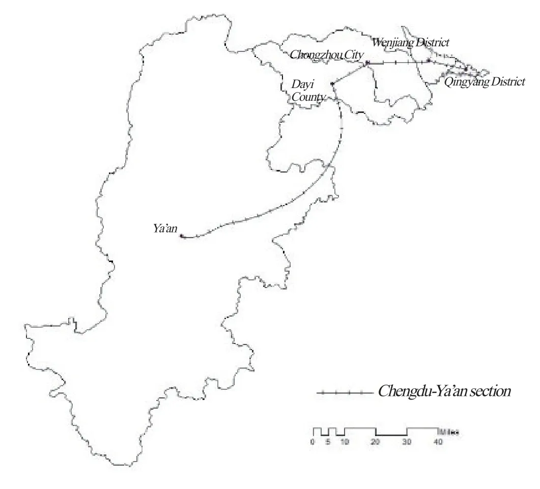
Figure 1. Research Area
Research Methods
By taking the Chengdu-Ya’an Section of STR as the research object, this paper attempts to study the influence of the railway on accessibility and economic link intensity of regions along the route. In this paper, weighted average travel time and gravity model are used to calculate indicators of cities along the rail, and GIS technology is employed to analyze changes before and after the operation of the Chengdu-Ya’an section. Additionally, the DID model is applied to empirically test the impact of STR on economic growth in cities and urbanization.
Accessibility refers to the difficulty in traveling from one specific area (town) to another within a specific territory. It is subject to geographic location and traffic conditions. It is generally measured by weighted average travel time and economic potential. In this paper, taking into account geographic locations and economic strength, we used the weighted average travel time to calculate accessibility. The formula is as follows:
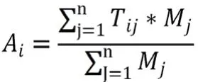
whereAirepresents the accessibility level of hub cityi; the smallerAiis, the higher the accessibility level of the city;Tijsignifies the shortest travel time (minutes) from cityito cityj.Mjis the economic level of cityj, symbolizing the economic impact of the city on the area along the route. It is often expressed by indicators such as GDP and permanent resident population. In this paper, it is expressed by the city’s GDP and the arithmetic square root of the the permanent resident population.
Economic link intensity is defined as the flow of production factors such as capital and labor between cities, as well as a series of associated and participatory economic behaviors arising from the flow of such factors. Economic link intensity is usually calculated using the gravity model. It is designed to demonstrate the central city’s ability to form urban agglomerations and the capabilities of surrounding cities to embrace the central city. The calculation formula is as follows:
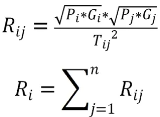
whereRijis the economic link intensity between two cities;PiandPjmean the permanent resident population of the two cities, respectively;GiandGjrepresent the total GDP of the two cities, respectively;Tijmarks the shortest travel time between the two cities;Riis the total economic contact intensity between cityiand its neighbors. The largerRiis, the closer the economic connection between a city and its neighbors.
In recent years, the DID model has been repeatedly used to evaluate the net effectiveness of economic policies. Specifically, it assesses the net impact of policies by dividing the sample into a treatment group and a control group, categorizing group members according to whether they are affected by policies, and calculating differences before and after policy interventions were implemented. This process is modeled on procedures of a natural science experiment. If the operation of STR can be regarded as a new public policy, DID model can be applied to verify whether it has promoted the local economy. The model is as follows:

whereYitis the explained variable designed to measure local economic development. In this paper, the urbanization rate is selected as the measurement index.treatiis a grouping dummy variable; for the treatment group consisting of cities located along STR,treatiis taken as 1; for the control group comprised of cities not situated along the route, it is 0.timetis the time dummy variable; for STR that was put into operation in 2018, it is set as 1 for the year of 2019 and 0 for 2018.treati×timetis defined astreated, representing the core explanatory variable designed to measure the net impact of railway operation; for cities that have already been connected by STR in 2019, it is set as 1; for those that have not, it is set as 0. We will focus our attention on the core explanatory variable, namelyβ3. Ifβ3> 0, it means the railway has a positive effect on the city proper economic growth. Ifβ3< 0, it suggests the railway is hampering the city proper economy.
Data Sources
In this paper, cities and districts we selected along the Chengdu-Ya’an section include Qingyang District, Wenjiang District, Chongzhou City, Dayi County, and Ya’an City, as well as Zigong City and Luzhou City that are not yet connected by the railway. Information about the shortest travel time between Chengdu and Ya’an is obtained from Gaode Map and the official website of Railway China 12306. The macroeconomic data comes from statistical yearbooks and the social development statistical bulletin of these cities.
Empirical Analysis
Accessibility Analysis
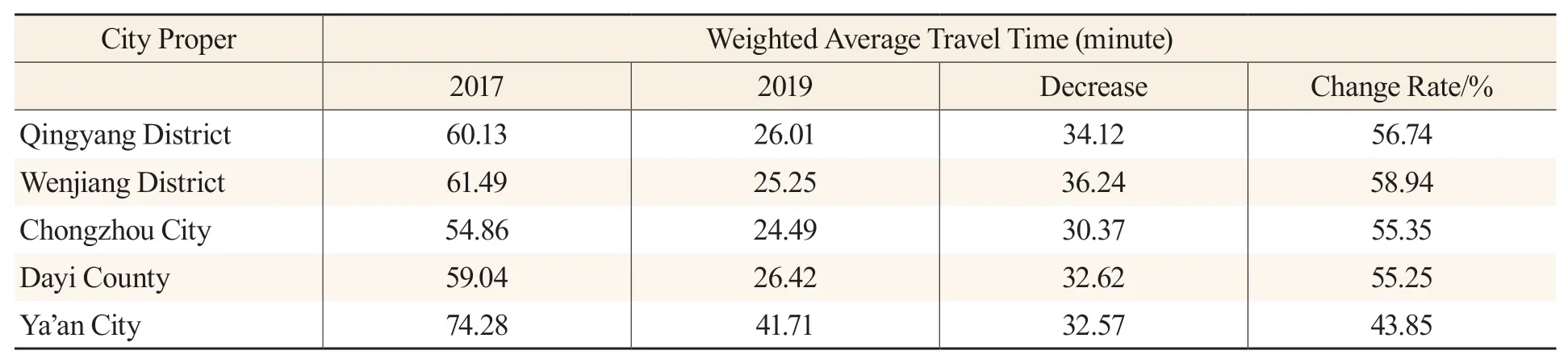
The Chengdu-Ya’an section of STR has reduced the distance between different city propers and significantly improved accessibility between different regions. The operation of the high-speed rail is bound to increase economic link intensity between the city propers and thus boost the regional economy. According to the accessibility model, changes in the weighted average travel time between the city propers along the Chengdu-Ya’an section of STR are shown in Table 1.
Tab.1 The Accessibility Changes before and after the Opening of Chengdu-Ya’an Section
The operation of the Chengdu-Ya’an section has greatly improved the accessibility of city propers along the route. Specifically, the weighted average travel time among the selected five city propers along the railway has been reduced from 61.96 minutes in 2017 to 28.78 minutes in 2019, a decrease of 53.56%. This improvement strengthened the connection between city propers, but the change rate in accessibility varies from place to place. Before and after the opening of the high-speed rail, no significant changes were observed in the overall accessibility of city propers along the route. For example, the change rates of several city propers in Chengdu were higher than the average. Only Ya’an experienced a small change in accessibility and saw a decline of 43.85 percent in its weighted average travel time. On the whole, cities along the Chengdu-Ya’an section have been significantly more accessible. This improvement is particularly noticeable in city propers of Chengdu which hold a geographical and economic advantage over Ya’an which has not yet witnessed obvious growth in accessibility. In studying changes in accessibility of city clusters in the Yangtze River Delta, Zhao Dan and Zhang Jingxiang (2012) observed a significant difference in the impact of high-speed rail on city proper accessibility, as central cities reap the most benefits while periphery cities receive the least rewards. As a result, city proper development efforts in the future will be focused on how to avoid the negative impact of high-speed rail and break the bottleneck of development. The changes in accessibility distribution before and after the opening of the Chengdu-Ya’an section are shown in the figure below.
As can be seen from Figure 2, after the section is put into operation, the accessibility of the city propers along the route has been greatly improved; however, no significant changes were seen in the spatial distribution of accessibility. The several areas in Chengdu are still the most accessible areas, and their weighted average travel time has been shortened to less than half an hour, which has strengthened economic ties between cities and will drive the economy. Compared with Chengdu, Ya’an is still the least accessible city. Li Lei et al. (2017) came to a similar conclusion when studying the impact of high-speed rail on city proper clusters within the Yangtze River Delta. The conclusion said that the opening of high-speed rail consolidated the core position of megacities such as Suzhou and Shanghai, leaving peripheral areas even further behind. Therefore, it is imperative for Ya’an City to leverage the railway to avoid becoming an economic and transport backwater.
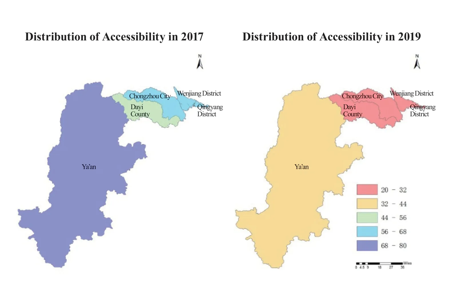
Figure 2. Spatial Distribution of Accessibility before and after the Opening of Chengdu-Ya’an Section
Analysis of Economic Link Intensity
The operation of the high-speed rail and better inter-regional accessibility has led to obviously higher economic link intensity. The economic link intensity between city propers along the route before and after the opening of the section is calculated by specified formulas. The changes are shown in Table 2 below.
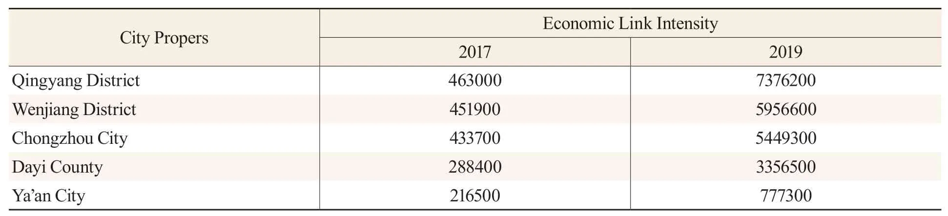
Tab.2 Changes of Economic Link Intensity before and after the Opening of Chengdu-Ya’an Section
As can be seen from the above table, before the completion of the Chengdu-Ya’an section, the average economic link intensity between city propers was 370,700. After completion of the section, compared with 2017, the economic link intensity of the city propers along the route saw a tenfold increase to an average of 4,583,200, with its range rising from 246,500 to 6,598,900. The results showed that better accessibility has resulted in higher economic link intensity between regions, but the differences in economic link intensity between city propers have grown more obvious. In 2019, the total economic contact intensity for Qingyang District stood at 737.62, while the number for Ya’an City was 77.37. As the capital city of Sichuan province, Chengdu has experienced a period of rapid economic growth, leaving Ya’an even further behind. This phenomenon has created a heavilypolarized economy and shown an obvious “siphon effect.”
From the perspective of GDP and permanent resident population, the gap between Ya’an City and other regions is not obvious, and the total economic volume is even stronger than that of other regions. However, huge differences have been seen in economic link intensity. According to the formula, economic link intensity is positively correlated with GDP and permanent resident population, but is negatively correlated with the shortest travel time. Since the shortest travel time in Ya’an is significantly longer than that of other regions, its economic link intensity is significantly weaker than that of those regions along the route. Tan Chenglin and Huang Xiaoya (2014) also came to a similar conclusion when studying the impact of the “Four Vertical and Four Horizontal” high-speed railway network of China. For example, they argued that there was a positive correlation between economic link intensity and accessibility of cities along a high-speed rail. Nevertheless, a larger gap, which is primarily subject to specific conditions of the cities, was observed in economic link intensity among different cities. The total intensity and trend in economic link intensity of each city before and after the opening of the Chengdu-Ya’an section are shown in the figure below.
With the help of ArcGIS technology, the total intensity and trend of economic link intensity between the city propers along the route are displayed more clearly. As can be seen from Figure 3, the economic link between Chengdu and Ya’an was weak in 2017. After the Chengdu-Ya’an section was put into service in 2019, the economic link intensity between the city propers has increased significantly, and the total economic link intensity between most city propers has increased to over one million. However, most of the areas are located in Chengdu. Although Chengdu is the provincial capital and the political and economic center of Sichuan, it does not exert a strong economic impact on other cities and areas of the province. The economic ties between Ya’an and Chengdu are weaker than those between different districts of Chengdu. This trend was also observed in researches on other important railways in the west of China. Kong Lingzhang et al. (2019) found that the opening of the Lanzhou-Xinjiang high-speed railway has improved the accessibility of economically advanced cities and strengthened their positions as central cities. This enhancement, however, depleted production resources of small and medium cities such as Hami and Turpan, thus hindering coordinated development of the regional economy. As a result, Chengdu should expand its economic influence to drive the economic development of the whole province. Ya’an should leverage the high-speed rail to strengthen economic links with other cities and integrate into the Chengdu-Chongqing economic circle to avoid being marginalized.
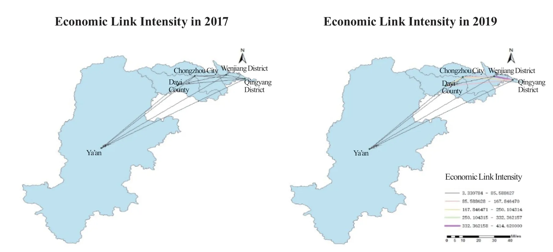
Figure 3. Distribution of Economic Link Intensity before and after Railway Opening
Impact on Urbanization
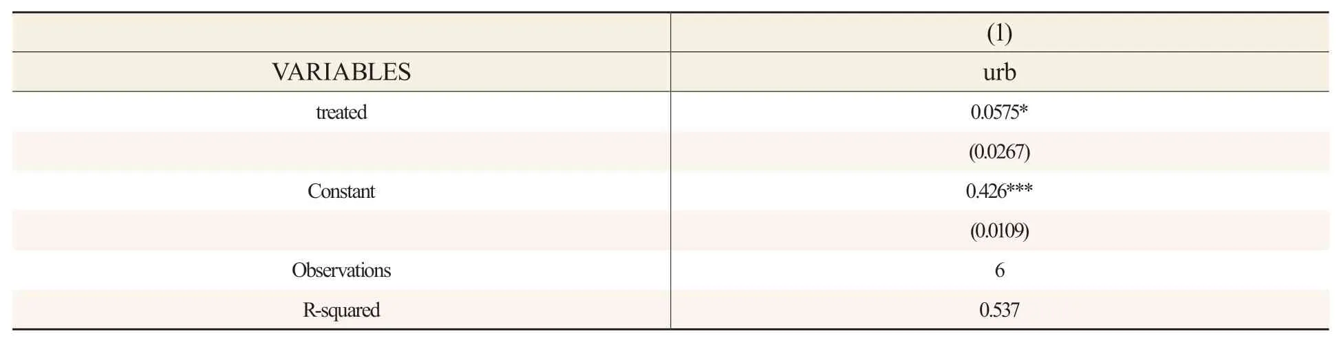
When analyzing the impact of railway opening on economy, this paper selected urbanization level as the explained variable. Also, as an important indicator of city proper economic development, urbanization represents a major engine for economic growth in China. The construction and operation of high-speed rail can help transfer surplus labor from rural areas to cities, a process conducive to the economic development of cities. Liu Yongzheng and Li Yan studied the impact of high-speed rail construction on city proper economic growth and urbanization in China. Their empirical results showed that high-speed rail is beneficial to urbanization and economic growth in cities. Also, when studying the Qinghai-Tibet Railway, which is similar to STR, Wang et al. (2015) applied the DID model and found that the Qinghai-Tibet Railway has promoted the development of underdeveloped areas along the route and increased the per capita GDP of counties along the railway by 33 percent. As can be seen from Table 3, the coefficient oftreatedis positive and statistically significant at the 10 percent significance level. Compared with Zigong and Luzhou, both of which have not yet been connected by railways, the contribution rate of railways to urbanization in Ya’an stands at 0.0575. However, other variables are not considered in this conclusion. This conclusion demonstrated that the opening of STR has accelerated the flow of population and transferred a large number of rural populations to cities, thus promoting the urbanization process of the region.
Tab.3 Impact of Opening of Chengdu-Ya’an Section on Urbanization Rate
Conclusion and Discussion
The opening and operation of the Chengdu-Ya’an Section have significantly improved interregional accessibility and economic link intensity. In 2017, there was little difference in economic link intensity between the regions. In 2019, the high-speed rail improved regional accessibility and increased economic link intensity between cities along the route. This boosted regional economic development and urbanization, but an increasing gap was seen in the link intensity between the cities, leading to polarized economic link intensities between the regions. Using weighted average travel time, economic link intensity, ArcGIS technology, and DID model, we studied changes in regional economic development along the Chengdu-Ya’an section before and after the opening of the railway. This study is helpful to clarify rules of economic development between cities to provide a reference for coordinated development between the regions and the development of STR. Our main conclusions are as follows:
(a) After the Chengdu-Ya’an Section was put into operation, the weighted average travel time of the five city propers we studied along the line has been greatly reduced, and the regional accessibility has been significantly upgraded. However, changes in accessibility were unbalanced. The accessibility of districts in Chengdu has been significantly improved. Specifically, Wenjiang District experienced the largest change in weighted average travel time, which dropped by 58.94 percent or 36.24 minutes, mainly because Chengdu, as the provincial capital, has a geographical and economic competitive edge. By comparison, changes in the accessibility of Ya’an were smaller than that of other cities. Fortunately, the opening of the entire STR will significantly enhance the accessibility of Ya’an.
(b) After the Chengdu-Ya’an section was put into service, economic link intensity between the five stations along the line has been significantly improved. The economic link intensity of the city propers of Chengdu was the highest, whereas that of Ya’an was the lowest compared with other cities along the route. Such a comparison of the trends in the indicators of different cities before and after the opening of the railway revealed that differences in accessibility and conditions of the cities have led to a startling contrast and imbalance in economic link intensity between cities. As a result, Ya’an should utilize STR to strengthen economic ties with neighboring cities and thus fuel coordinated economic development within the region. For other underdeveloped cities along STR, it is necessary to formulate more active policies to avoid uneven development.
(c) Significant changes were observed in the accessibility and economic link intensity before and after the opening of the Chengdu-Ya’an section, meaning that the section is playing an increasingly important role in driving the economic growth of cities along the route. After being completed, STR will connect western Sichuan and Tibet and facilitate the flow of labor and capital. However, it could also give rise to the outflow of talents and capital from underdeveloped cities. It is, therefore, both a challenge and an opportunity for city propers along the route to make good use of the railway to achieve growth. Cities along the route should tap into their advantages and integrate into the regional economic circle to ultimately achieve coordinated regional economic development.
(d) In accordance with the panel data of Ya’an, Zigong, and Luzhou in 2018 and 2019, this paper used the DID model to study the impact of the railway on the economic development of Ya’an. Our study proved that the opening and operation of the Chengdu-Ya’an section has significantly stepped up the urbanization drive of Ya’an and accelerated the flow of capital and labor, thus fueling the local economy. Convenient transport infrastructure has improved regional accessibility and strengthened regional connections. Looking to the future, the cities should focus their attention on how to leverage high-speed rail for their benefits.
Therefore, all the regions should formulate economic policies according to their local conditions and facilitate the construction of railways that could better serve the local economy. Of particular note, the opening and operation of railways may put some underdeveloped areas at the risk of resources outflow. In this sense, active policies should be formulated to reduce the outflow of high-quality resources and attract more resources into these areas so as to bridge the economic gap between different regions. Central cities should expand their economic influence and promote resources sharing to avoid serious “siphon effects” and boost coordinated regional economic development.
Discussion
By studying accessibility and using the DID model, the paper analyzed the changes before and after the opening of the Chengdu-Ya’an section of STR. However, as the model was simple and there was a lack of data, it was impossible to fully evaluate the impact of the railway on the economic development of cities along the route. On top of this, most parts of STR are still under construction, and therefore only the Chengdu-Ya’an section was studied as a whole, suggesting that there might be some deviations in our conclusions. As a result, the accuracy and depth of the research conclusions need to be further improved after the entire STR is put into operation. To that end, we should update data and correct models promptly to deliver accurate assessment results.
 Contemporary Social Sciences2021年6期
- Contemporary Social Sciences的其它文章
- Wang Xizhi and Sichuan
- 《当代社会科学(英文)》稿件格式参考
- Does Environmental Regulation Increase Employment? Based on the SCM and RCM Methods
- A Study of the European Union’s Path for Constructing Digital Governance Rules and the Logical Implications of the Path
- A Study of Idiom Translation in Bonsall’s The Red Chamber Dream
- Wang Chuan’s Abstract Painting: A Contemporary Expression of Chinese Zen Ink Painting