
Stability of loess high-fill slope based on monitored soil moisture changes
2024-01-02 14:41XueLingYongYuZhngYunLongHouBingBingHnNingAnHuiZhngYing
XueLing Yong ,Yu Zhng* ,YunLong Hou ,BingBing Hn ,Ning An ,Hui Zhng ,Ying M
a School of Traffic and Transportation, Lanzhou Jiaotong University, Lanzhou, Gansu 730070, China
b Key Laboratory of Railway Industry of Plateau Railway Transportation Intelligent Management and Control, Lanzhou Jiaotong University, Lanzhou, Gansu 730070,China
c Gansu Institute of Engineering Geology, Lanzhou, Gansu 730030, China
d School of Civil Engineering, Lanzhou Jiaotong University, Lanzhou, Gansu 730070, China
Keywords:Rainfall infiltration Seepage stress coupling Loess High fill slope Stability
ABSTRACT This paper aims to assess the influence of moisture content changes during rainfall on the stability of loess high-fill slopes by taking a loess high-fill slope in Lanzhou City as an example.First,according to the moisture content monitoring data collected from a slope online monitoring system,direct shear tests were performed on soil samples of different moisture content to determine the relationship between the shear strength parameters and moisture content.Next,a coupled hydro-mechanical model with soil shear strength related to moisture content was established and used to analyze 16 working conditions with various rainfall intensities and durations for two cases: shear strength parameters from the site exploration report and those from this study.Finally,the results from the two cases were compared regarding the changes in stresses and displacements after rainfall infiltration to analyze the influence of moisture content on the stability of loess high-fill slopes.The conclusions are as follows:(1) Segmental relationship equations of cohesion and angle of internal friction were established for loess with various moisture content.(2) Under the conditions of different rainfall intensities,significant differences were observed in the trends of slope stress and displacement changes.(3) The slope displacement occurred in the shallow soil layer within about 12.5 m from the slope top,and the plastic strain concentrated in the soil layer within about 6 m from the slope top.(4) The results of slope stability analyses based on moisture content monitoring data are more in line with the observed.
1.Introduction
Loess is a Quaternary sediment with unique characteristics-its loose soil structure and high porosity make it susceptible to water disintegration and wetting subsidence.Its internal structure also contributes to its engineering properties.Failure in loess foundations often manifests as wet subsidence,liquefaction,and vibration subsidence.Loess slopes are prone to collapse,slump,landslide,and slope scouring.
This study is based on the theory of energy analysis that assumes the strength parameters,including cohesion and internal friction angle,are discounted by different factors.Different ways were adopted to define the integrated slope safety factor based on the discount factors,and the expression of the objective function of the respective integrated safety factor was deduced according to the principle of virtual work(Zhaoet al.,2014).They converted the spatial and temporal distributions of matric suction,volumetric moisture content and other variables obtained from the coupled analysis into the spatial and temporal distributions of equivalent cohesive forces and developed a vector sum method analysis program for the stability of unsaturated soil slopes under unsteady seepage conditions based on the spatial and temporal distribution of the strength parameter on the Matlab platform(Xueet al.,2016).Chenget al.(2017) conducted a study on the effect of rotational anisotropic correlation structures on the stability of clay slopes by considering the spatial variability of soil properties.Other studies proposed new methods for searching slope sliding surfaces and calculating safety coefficients(Xiaoet al.,2013;Chenet al.,2021).
Cho(2009)presented a numerical procedure for integrating the finite difference method into the probabilistic analysis of slope stability.An artificial neural network (ANN)-based response surface is used to approximate the limit state function,which reduces the amount of computations for stability analysis.Bellugiet al.(2015) proposed an effective deterministic search algorithm based on spectral graph theory combined with a multidimensional stability model to predict a wider range of discrete landslides using grid space data.They investigated the stability of bimrocks (block-in-matrix rock) slopes based on the finite element method and limited equilibrium method.It is concluded that twin rock materials should be considered heterogeneous to avoid errors.Furthermore,Napoliet al.(2018) emphasized the benefits of using stochastic rather than deterministic methods for slope stability analysis of these heterogeneous materials;they conducted physical model tests by constructing a tilt table device,measured the angle of the slip surface of the slope,and developed a numerical model based on the results of the finite difference method and the physical bilateral slope model (Khorasaniet al.,2019).
Regarding the effect of moisture content on slope stability,Fredlundet al.(1978)proposed an equation for the shear strength of unsaturated soils.Previous studies investigated the pattern of change in the shear strength at varying moisture content for loess(Wang and Lin,1990;Shaoet al.,2009).Liuet al.(2006) suggested that rainwater infiltration reduces soil's matric suction in the unsaturated zone,which is the main factor leading to the reduction of slope stability.Fuet al.(2012)proposed a new approach that considers both the seepage field's influence on slope stability and the detrimental effects of rock softening effects on slope destabilization.Additionally,Zhanget al.(2014) considered the interaction between unsteady seepage and nonlinear deformation of heavy rainfall,conducted a coupled analysis of transient seepage and stress fields of saturated-unsaturated slopes,and proposed a method for evaluating the damage proximity under the coupled action of seepage and stress.
Many studies have been conducted to investigate the effects of rainfall on slope stability.Sammori and Tsuboyama (1991) analyzed how the stability conditions of slopes are affected by different rainfall scenarios and initial surface and boundary conditions.The study shows that the most important factor affecting slope stability is soil permeability coefficient.Egeli and Pulat (2011) developed the Soil-Water Interaction Modeling System(SWIMS),considering shallow landslides where rainfall can infiltrate into non-cohesive to slightly cohesive soils.Several studies conducted analyses of slope stability under unsaturated conditions based on the principle of effective stress(Santosoet al.,2011;Oh and Lu,2015).
New models have been proposed to account for rainfall infiltration in slope stability analyses.Bandaraet al.(2016) proposed a dynamic fully coupled formulation was proposed for large deformed saturated-unsaturated soils based on the material point method.Chaithong (2017) presented a method to analyze the response of slopes to rainfall infiltration during extreme events in mountainous areas by means of the Green-Ampt infiltration model and the infinite slope analysis model.Additionally,Troncone A.et al.(2021) suggested a method for assessing changes in groundwater levels due to rainfall using the water balance equation;they related these changes to landslide displacements using the equation of motion and used these equations in the initial assessment of rainfall-induced landslide movement in the presence of stabilization piles.
In summary,regarding the influence of moisture content on slope stability,many studies attempted to improve the determination of slope sliding surfaces,assess the influence of moisture content variation on soil parameters,refine the calculation of safety factors,and suggest corresponding analysis theories and methods.Generally speaking,during the rainfall process,the moisture content and mechanical parameters of the soil change with the rainfall intensity and duration.However,most existing studies are based only on the single soil moisture content and mechanical parameters obtained from the investigation to conduct slope stability analyses.In this paper,based on the dynamic monitoring of soil moisture content by the online slope monitoring system,two slope analysis models are established using the soil parameters and the shear strength parameters based on the monitored moisture content.The seepage stress calculation is performed to compare and analyze the stability using the two models under different moisture content.
2.Engineering background
The slope(Fig.1)is located in Lanzhou City,Gansu Province.The site belongs to the Loess Plateau of Longxi,with most of the area covered by loess and tilted from southeast and northeast to northwest.The terrain is high in the south,low in the north and low-lying in the center,in the shape of a saddle.It can be divided into three parts:stony mountains in the south,loess hills and gullies in the center,and loess hills in the north,with the northern and northeastern parts characterized by rolling hills and gullies.According to the regional geological data,the project area mainly consists of Holocene Su-fill (Q4ml) and Upper Pleistocene windformed Malan loess (Q3eol).

Fig.1.The slope at the site.
The regional climate belongs to the temperate semi-arid climate zone of the Loess Plateau,with a dry climate,cold winters,and large diurnal temperature differences.Precipitation mostly concentrates in July,August,and September,resulting in dry winter and spring seasons with little rain and much wind and sand,while intense evaporation occurs year-round.Investigation of historical rainfall data in the region yielded a historical maximum daily rainfall of 96.8 mm (https://data.cma.cn/Dat aCollect/index.html).
Investigation of historical weather temperature data in the region yielded an average high air temperature of around 19°C from 2020 to 2022,and an average low air temperature at 3°C in 2021 and 2022.The extremely high air temperature showed an increasing trend,reaching 39°C in 2022,and the extreme low air temperature is between-17°C to-20°C(Fig.2).

Fig.2.Temperature change in Lanzhou (2020-2022).

Fig.3.Maximum monthly soil temperature (2022.7-2023.3).
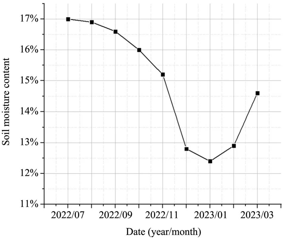
Fig.4.Maximum monthly soil moisture content (2022.7-2023.3).

Fig.5.Maximum monthly rainfall (2022.7-2023.3).
The slope had a length of 163 m and a height of 10-15 m.According to the site investigation,the left side of the slope was subject to the combined effects of rainfall and surrounding greening,resulting in tilted deformations of the original slope and the collapse of the road surface at the slope top,which affected the surrounding buildings.The slope monitoring system,i.e.,Lanzhou loess high fill slope automated monitoring system,consists of soil temperature and moisture sensors,rain gauges,etc.,and was used to monitor the slope soil affected by the rainfall intensity of large areas;all the monitoring data was stored in the "Lanshan cloud" platform.Analysis of the monitoring data found that from July 2022 to March 2023,the maximum soil temperatures occurred from July to October,with a maximum soil temperature of 28.4°C,and the minimal soil temperatures in winter,lower than 3.9°C.Rainfall was concentrated in July,August,and September,with a maximum rainfall of 27.8 mm,and the soil moisture was also higher during the same period,with a maximum soil moisture of 17%(Figs.3-5).
3.Sample preparation and shear strength tests
3.1.Sample preparation
Direct shear tests were carried out to determine the basic physicalmechanical parameters,such as the strength parameters,to provide data for the numerical models.The loess sampled from the study site was used as the test soil samples.Disturbed soil sample specimens were prepared according to the "Highway Geotechnical Test Procedure"(Research Institute of Highway Ministry of Transport,2020) JTG 3430-2020.The moisture content of the specimens ranged between 11.4% and 17.0% based on the monitoring data under rainfall conditions,and the natural density was 1.79×10³kg/cm3according to Gansu Engineering Geology Research Institute.The disturbed soil specimens were compacted to 96%to achieve the same density as that in the field.A total of five groups of specimens with different moisture contents (i.e.,11.4%,12.6%,13.8%,15%,and 16.2%) were prepared for direct shear tests to obtain the relationship between shear strength and moisture content.
3.2.Direct shear test
The direct shear test is a standard method to obtain the shear strength of soil.It is common to use multiple specimens to conduct tests under different vertical pressures to obtain shear stress-shear displacement relationships.These data are then analyzed according to the Mohr-Coulomb failure criterion to determine the shear strength parameters,including the angle of internal friction and cohesion.This study used a strain-controlled direct shear to perform fast direct shear tests.No consolidation was allowed after the vertical pressure was applied.
The vertical loads were 50 kPa,100 kPa,200 kPa,300 kPa,and 400 kPa.The shear rate was set at 0.8 mm/min,and the test was terminated when the shear displacement reached 6 mm,according to the Institute of Highway Science,Ministry of Transportation,China.The shear stress corresponding to a shear displacement of 4 mm was taken as the shear strength.Fig.6 depicts the shear stress versus shear displacement curves for specimens of varying moisture content.The relationship between peak shear strength and overburden pressure was obtained and illustrated in Fig.7.

Fig.6.Shear stress vs.shear displacement curves for specimens of varying moisture content.

Fig.7.Shear strength line under different moisture content conditions.
Based on the Mohr-Coulomb failure criterion,a linear regression analysis of the above test results was carried out to obtain the values of cohesion c and internal friction angle φ for the soil samples with different moisture content.The variation of the cohesion and internal friction angle with moisture content is illustrated in Fig.8.

Fig.8.Variation of shear strength parameters with moisture content.
Fig.8 shows that the soil moisture content significantly affects both the cohesion and the angle of internal friction.For example,when the soil moisture content increased from 11.4%to 12.6%,the cohesion decreased from 25.6 kPa to 23.6 kPa,or by 8.0%;when the soil moisture content rose from 12.6% to 16.2%,the cohesion dropped from 23.6% kPa to 21.0% kPa,or by 11.1%.In contrast,the effect of increasing moisture content on the angle of internal friction is different from that of cohesion.Only a slight drop in the angle of internal friction was observed when soil moisture content rose from 11.4% to 12.6%.However,the decline is more significant with a further increase in moisture content.For instance,the angle of internal friction decreased from 31.6°to 31.2°,a mere 1.3%,when soil moisture content rose from 11.4%to 12.6%,whereas the same declined from 31.2°to 26.1°,by 16.3%,when soil moisture content increased from 12.6%to 16.2%.
Therefore,according to the general trend and the correlation between the shear strength parameters and moisture content,two relationships were established with the moisture content of 12.6%as the boundary to provide an empirical evaluation of the shear strength parameters for the loess in the study site,as shown in Equations(1)and(2):
4.Numerical models and analysis schemes
4.1.Model creation and parameter selection
The automated monitoring system for loess high-fill slopes includes a set of four soil temperature and moisture content sensors that observe the impact of rainfall on the strength of the slope soil.Since rainfall has a greater impact on the shallow(1.5 m from the top of the slope)soil layer than the deep(it is more than 1.5 m from the top of the slope)ones,the maximum moisture content of two different soil depths was extracted from the monitoring data.Specifically,the maximum moisture content of the shallow layer was found to be 16.5%,corresponding to a cohesion of 13.0 kPa and an angle of internal friction of 28.8°.Meanwhile,the maximum moisture content of the deeper layer was 11.4%,corresponding to a cohesion of 15.6 kPa and an angle of internal friction of 33.3°.
Table 1 lists the soil properties of the study site as suggested by the investigation report provided by Gansu Engineering Geology Research Institute,and Table 2 summarizes the soil shear strength parameters calculated by Equations (1) and (2) based on the maximum moisture content observed in situ.These two sets of strength parameters were used to analyze the seepage stress coupling effect on the stability of loess highfill slopes.

Table 1 Soil parameters provided by the site study report.

Table 2 Soil parameters based on monitored moisture content.
For the chosen soil slope model,which measures 40 m in height and 50 m in width,the upper layer of soil consists of fill,while the lower layer is loess.The slope stability under rainfall infiltration conditions was analyzed using COMSOL Multiphysics software.A free triangular mesh was employed to discretize the two soil layers,resulting in a completemesh of 1528 domain cells and 134 boundary cells,as illustrated in Fig.9.

Fig.9.Schematic diagram of the mesh (Unit: m).
The mode's boundary conditions significantly influence the accuracy and reliability of the numerical analysis outcomes.This study employed the solid mechanics and Darcy's law modules to create numerical models of the slope under rainfall infiltration.In Darcy's law module,the slope surface was defined as the rainfall boundary,and the lower boundary was defined as an impermeable boundary.The model set the initial groundwater level of the right side to 19.8 m and the left side to 33.5 m.Moreover,the rainfall infiltration boundary condition with a rainfall intensity ofkshould always be considered.In the solid mechanics module,fixed constraints were placed on the lower surface of the model to limit the horizontal displacement on the left and right sides,and the upper surface was left undefined.The self-weight of the soil body W served as the external load on the model.
4.2.Soil-water characteristic curves
The permeability coefficient of unsaturated soils can be linked to the soil moisture content.Determining the soil-water characteristic curve and permeability function of unsaturated loess experimentally is costly and time-consuming.Thus,this study chose to fit an empirical model using available experimental data.Specifically,the VG model was selected for this purpose.The expression for the unsaturated permeability coefficient versus the soil-water characteristic curve represented by the VG model is given below:
where"θ"is the volumetric moisture content;"ψ"is the matric suction;"θs"is saturated moisture content(cm3/cm3);"θr"is residual moisture content(cm3/cm3);"a" a parameter related to the air intake value,is inversely proportional to the diameter of the average soil pore space(cm-1),which is generally larger for clayey soils than sandy soils;"b" is a parameter related to the rate of soil dewatering when the matric suction is greater than the inlet value;and "c" is a parameter associated with the residual moisture content.Among these parameters,θsand θrcan be directly measured,and the values of a,b,and c need to be obtained to derive the exact form of the VG model.
Li Pinget al.conducted matric suction tests on six sets of Holocene loess samples from 5 m deep(Table 3)by tensiometer and obtained the soil-water characteristic curves,as shown in Fig.9.Based on the particle gradation of loess in Lanzhou City by Li and Li,2013,the values of the five parameters of the VG model (Table 4) were evaluated by RETC to obtain the fitted soil-water characteristics,as illustrated in Fig.10.

Table 3 Measured matric suction values and volumetric moisture content of Q4 loess(Li and Li,2013).

Table 4 Values of the five parameters of the VG empirical model (Jin,2018).

Fig.10.Soil-water characteristic curve.

Fig.11.Initial volumetric moisture content (Unit: m).

Fig.12.Initial degree of saturation (Unit: m).

Fig.13.Initial pore water pressure (Unit: m).

Fig.14.Maximum von Mises stress variation.

Fig.15.Variation of Minimum principal stress with rainfall duration.

Fig.16.Variation of displacement with rainfall duration.

Fig.17.Displacement cloud plot.
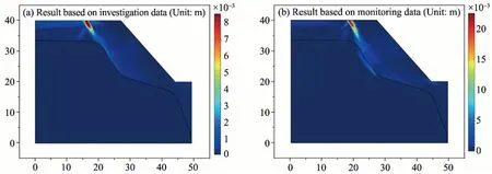
Fig.18.Plastic strain cloud plot.
4.3.Simulation of operating conditions
China divides rainfall intensity into six levels,namely light rain(<10 mm/d),moderate rain(10-25 mm/d),heavy rain(25-50 mm/d),torrential rain(50-100 mm/d),downpour(100-250 mm/d),and heavy downpour rainfall(>250 mm/d)(Table 5).

Table 5 Breakdown of rainfall intensity.
The daily maximum rainfall of 27.78 mm(heavy rain)was observed from 2022 to 2023 by the slope monitoring system.Considering the historical daily maximum rainfall of 96.8 mm recorded in 1978 in this area,according to the statistics of the National Meteorological Information Center (China Meteorological Data Network,2021),the following rainfall scenarios were considered in the model simulation,including 24 mm/d (moderate rain),40 mm/d (heavy rain),80 mm/d (torrential rain),97 mm/d (historical maximum rainfall intensity).The setting of rainfall conditions is shown in Table 6.

Table 6 Setting of rainfall conditions.
5.Slope stability analysis
5.1.Stress and displacement results
The COMSOL Multiphysics software was utilized to conduct a rainfall seepage-stress coupled analysis of the slope,employing both the solid mechanics and Darcy's law modules.The slope stability analysis was performed using a combination of 32 rain intensities and durations specified above.Figs.11-13 present the initial moisture field.
Two sets of soil strength data,i.e.,those provided in the investigation report (Table 1) and those based on the monitored moisture content(Table 2),were used to carry out the coupled seepage stress analyses under 16 cases with various rainfall intensities and durations.Figs.14-18 display the analysis results,including von Mises stresses,displacement,and plastic strain.Notably,the numerical results using the shear strength parameters provided by the investigation report are denoted as the"result based on investigation data" and those using the shear strength parameters obtained by using moisture content from the slope monitoring system are referred to as the"result based on monitoring data".
Generally,as rainfall intensity and duration increase,rainwater slowly permeates the soil.It increases the moisture content and the degree of saturation in the slope soil,resulting in a decline in the slope soil's shear strength and a rise in its displacement,hence elevating the risk of failure.
Under identical rainfall intensity,a rise in rainfall duration led to the escalation of mises stress,minimum principal stress,and slope displacement.When rainfall intensity reaches 97 mm/d,results based on the selected survey data show that an increase in duration from 2 days to 8 days leads to elevated mises stress,rising from 215.2 kPa to 217.3 kPa,and higher minimum principal stress,from 664.3 kPa to 668.4 kPa,as well as a larger slope displacement,increasing from 6.18 mm to 22.6 mm,as shown in Figs.14-16a.The results from the model using the shear strength parameters obtained from monitored data are shown in Figs.14-16b and reveal that the Mises stress increased from 249.4 kPa to 250.8 kPa,the minimum principal stress increased from 666.7 kPa to 671.2 kPa,and the slope displacement increased from 7.1 mm to 23.8 mm.
At the same rainfall duration,the von Mises stress,minimum principal stresses,and slope displacements on the slope increase with rainfall intensity.When the duration of rainfall is eight days and the intensity of rainfall increases from 24 mm/d to 97 mm/d,the results of the soil parameters presented in the chosen investigation report indicate(Figs.14-16a) that the Mises stress rises from 215.3 kPa to 217.3 kPa,and the minimum principal stress increases from 664.4 kPa to 668.4 kPa,and the slope displacement increased from 7.8 mm to 22.6 mm.The results for soil parameters based on monitoring data (Figs.14-16b)reveal that the von Mises stress increased from 249.7 kPa to 250.8 kPa,and the minimum principal stress increased from 667.3 kPa to 671.2 kPa.Additionally,the slope displacement increased from 8.7 mm to 23.8 mm.A comparison of the results from the two models reveals that the von Mises stress,minimum principal stress,and displacement are greater in the model based on the monitoring data.This indicates that the soil body's tensile and compressive strengths are higher under the conditions of this model.Furthermore,the compressive stresses in the slope are larger,rendering the slope more vulnerable to failure.
After eight days of rainfall,the displacement change and slope plastic strain cloud plots (Figs.17 and 18) revealed that both models showed concentrated slope displacement and plastic strain in the shallow soil at the top of the slope.The displacement was confined to the fill layer within approximately 12.5 m beneath the top of the slope,while the plastic strain occurred in the fill layer within a depth of about 6 m at the top of the slope.Furthermore,the sliding surface was formed along the contact surface.Therefore,rainfall primarily affects the top of the slope and the adjacent areas,resulting in a higher likelihood of landslides in these zones.
The computational model that used soil parameters obtained through monitoring data exhibited a higher rise in maximum and minimum principal stresses and slope displacement caused by rainfall infiltration.It also demonstrated more significant variations in the computed stresses and displacements than the model that used soil parameters obtained through survey data.Under 24 mm/d and 40 mm/d,the slope displacements and stresses changed gradually during the first four days of rainfall but then rose significantly.Meanwhile,under the conditions of 80 mm/d and 97 mm/d,the slope displacements and stresses rapidly increased from the start of the rainfall and remained almost the same.
5.2.Analysis of slope safety factor
Evaluating slope stability during rainfall involves determining slope safety factors through strength discounting.During the assessment of the unsaturated soil slope under rainfall infiltration conditions,the internal friction angle and cohesion were discounted by the reduction factor to conduct a finite element analysis,with the changes in the angle of internal friction and cohesion over time due to rainfall accounted for.The ratio of the original strength parameters and the reduced parameters in case of slope failure is the safety factor of the slope(Donget al.,2009).
The safety factors for the slope were computed for the two models described earlier in 32 different working conditions.These conditions encompassed varying durations and intensities of rainfall.Subsequently,the slope stability was analyzed using the criteria from the"Specification for Landslide Prevention and Control Engineering Investigations"(GB/T 32864-2016)(Ministry of Natural Resources,People’s Republic of China,2016)to classify its stability state(Table 7).

Table 7 Criteria for determining the safety factor.
As shown in Fig.19,the safety factors of both models exhibit a gradual decline during various rainfall intensities over an eight-day period.Additionally,the factor of safety reduces with higher rainfall intensity during the rainfall duration.As such,the slope stability state deteriorates to instability as rainfall intensities become progressively higher over the eight-day period.By comparing the changes in the slope safety factor under four distinct levels of rainfall intensity,it is evident that the safety factors corresponding to rainfall intensities of 24 mm/d and 40 mm/d reduce less than 80 mm/d and 97 mm/d during the four days of rainfall.This may suggest that these two levels of rainfall intensity are comparatively low,and the quantity of rainwater infiltrating into the slope soil is also relatively small.The minimal impact on the groundwater level causes a slight decrease in the pore water pressure and matric suction of the soil on the slope.Consequently,the reduction in the shear strength of the slope soil is not significant,and the slope factor does not exhibit an evident downward trend over time.During the 6-8 days of rainfall,the safety factors for four different intensities decrease.With a relatively flat slope and a rainfall intensity of 24 mm/d,the slope remained stable.However,for the remaining three intensities,the slope became unstable.

Fig.19.Variation of slope safety factor with rainfall intensity and duration for two cases.
Comparing Figs.19a and 19b,the safety factor decreases more in the model using soil parameters calculated from monitoring data than in the model with soil parameters based on survey data.This decrease is more noticeable for four days of rainfall.The intensity of rainfall reduces the pore water pressure and matric suction force of the slope significantly.As a result,there is a noticeable reduction in the shear strength of the soil,leading to a quick drop in the safety factor.Moreover,the initial shear strength of the model with soil parameters based on monitoring data is lower than that with soil parameters based on survey data,further accelerating the decrease in the safety factor.
Based on the calculations,the two models predict that the slope can remain stable at a rainfall intensity of 24 mm/d or less.However,the slope becomes unstable at higher rainfall intensities,making it vulnerable to external forces and damage.These results align with actual observations.From Fig.20,it is evident from the discounted plastic strain diagram that the slip surface is in the shape of a circular arc,positioned proximate to the contact surface between the fill and loess (Fig.21).
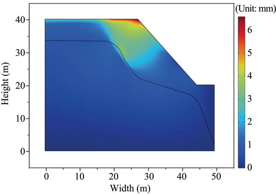
Fig.21.Displacement after strength reduction (Unit: m)
5.3.Discussions
The historical rainfall data of Lanzhou City were collected(Tianqi 24,2023,https://www.tianqi24.com/),and the displacement monitoring data of the slope GNSS(Global Navigation Satellite System) monitoring station corresponding to the date and rainfall amount were retrieved from the monitoring data repository"Lanshan Cloud",as listed in Table 8.The trend from the displacement data from the GNSS monitoring station located at the top of the slope(Fig.22)helps predict the possibility of a landslide.

Table 8 Displacement monitoring data from the GNSS station.

Fig.22.Location of the GNSS monitoring station.
Under the condition of 24 mm/d rainfall intensity and a 2-day rainfall duration,numerical modeling based on survey data revealed a maximum displacement of 1.3 mm at the top of the slope,while the numerical model based on monitoring data revealed a maximum displacement of 2.2 mm at the top of the slope.
As indicated in Table 8,the recorded displacements range from 1.1 mm to -2.7 mm under moderate rainfall conditions,and the displacement results obtained from numerical calculations fell within this range,thus suggesting the numerical model's reasonableness.Considering the accuracy of the numerical model,the following points are considered to analyze the reasons for the deviations.
(1) The numerical model was designed with a rainfall intensity of 24 mm/d,while the actual rainfall data only serves as a reference value.Consequently,there is a slight deviation between the numerical model's results and those obtained from the displacement gauge.
(2) The numerical model considers a uniform rainfall rate,whereas,in reality,there is often an uneven distribution of rainfall and the occurrence of alternating rainfall with multiple intensities.
(3) In the numerical model,the soil is assumed to be without any vegetation.However,in practice,the soil on the slope is largely vegetated,considerably prolonging the infiltration duration,decreasing surface runoff,and augmenting the infiltration volume through water stagnation by the vegetation.
6.Conclusions
(1) Through the direct shear test,it was found that the cohesion and the angle of internal friction of the soil decrease with the increase in moisture content.When the moisture content of soil samples increases from 11.4% to 16.2%,the cohesion of soil samples decreases from 25.6 kPa to 21.0 kPa,and the angle of internal friction decreases from 31.6°to 26.1°.
(2) Under the conditions of rainfall intensity of 24 mm/d and 40 mm/d,the displacements and stresses at the slope top show a relatively gradual change within four days of rainfall and then increase significantly;under the conditions of rainfall intensity of 80 mm/d and 97 mm/d,the stresses and displacements at the slope top rapidly rise from the beginning of the rainfall,and the trend remains unchanged.
(3) The effect of rainfall infiltration on the slope soil is concentrated in the shallow soil layer.The rainfall infiltration causes the displacement in the shallow soil layer within about 12.5 m from the slope top,the plastic strain mainly occurs in the soil layer within about 6 m from the slope top,and the slope moves towards the slope toe along the fill-loess interface.
(4) The slope's safety factor gradually reduces as the rainfall intensity
increases.After eight days of rainfall,the slope remains stable for the intensity of 24 mm/d but becomes unstable for the three higher rainfall intensities.
Acknowledgments
This research was supported by a grant from the Gansu Provincial Department of Natural Resources Science and Technology Innovation Talent Cultivation Project(2022-09),the Geological Disaster Prevention Projects of the Gansu Provincial Bureau of Geology and Mineral Resources,and Natural Science Foundation of Gansu Province (No.22JR5RA326).These supports are much appreciated.
 Sciences in Cold and Arid Regions2023年4期
- Sciences in Cold and Arid Regions的其它文章
- Influence of relative compaction and degree of saturation on thedeformation characteristics of bentonite under freeze-thaw cycles
- Dissolved organic carbon fractionation in wet deposition and its potential impact on radiative forcing in the central Tibetan Plateau
- Pore evolution and shear characteristics of a soil-rock mixture uponfreeze-thaw cycling
- Extracting water body data based on SDWI and threshold segmentation: A case study in permafrost area surrounding Salt Lake in Hoh Xil,Qinghai-Tibet Plateau,China
- 《寒旱区科学》(英文)关于数据论文关联数据提交的倡议书