
浅谈西班牙中型城市绿色基础设施战略如何为公众健康带来福祉:拉科鲁尼亚案例分析
2013-10-31 08:17撰文西班牙佩德罗卡尔拉萨马汀尼兹西班牙路易斯里贝罗翻译邝嘉儒
风景园林 2013年6期
撰文:(西班牙)佩德罗 · 卡尔拉萨 · 马汀尼兹 (西班牙)路易斯 · 里贝罗翻译:邝嘉儒
Text by:Pedro Calaza-MARTÍNEZ(ES) Luis RIBEIRO(ES) Translation by:KUANG Jia-ru
1 导言
联合国人口活动基金会的最新一份数据统计表明,从2010年起,世界上超50%的人口都居住在城市区域。尽管城市确实能够为人们提供多种机遇,如就业和增长知识、文化等,但它们也有消极的一面,如生活节奏快,休闲区域缺乏,社会凝聚力低下以及公众健康状况不良。在全球可持续发展的框架内,有许多战略都在尝试解决上述问题并设法建设更健康的城市,其中最突出的是绿色基础设施(GI)战略。众所周知,虽然不同学者对绿色基础设施的概念与内涵看法各不相同(本尼迪克特与麦玛宏,2006;修维斯特,2009),但绿色基础设施仍然是一个强大的多层次规划战略,正在全球范围内以迅猛之势蓬勃发展。大量科学性与技术性研究已经证明,绿色基础设施及其各组成部分如绿色廊道、公园、花园等,都拥有多种功能性(法布士,1995;兹欧拉斯等,2007),形成一个能够带来包括公众健康(PH)在内的多利益复杂系统。
通过分析西班牙东北部拉科鲁尼亚市(LGG)的案例(图01),我们认为市级与省级的绿色基础设施战略可能是解决中型城市现有问题,如人口密度高、特殊城市外观、地理选址及人口心理障碍等的合适方法。它产生的公众健康利益是双面的:预防与经济节约。
2 背景与文献综述
我们知道,快速城市化已经对公众健康与社会福利产生重大的影响。为了使人口适应多种复杂环境,人造环境已经取代了自然环境。而这一情况在更加过度拥挤的城市中更为严重。这些城市几乎没有公共空间以供体育锻炼,加上热岛反应频繁,污染更加严重等原因,其疾病的发生概率比其他城市更高。正是这些类似LCG的城市,由于缺乏合适的区域,无法为居民提供有利的环境,因而不能产生各种像保守治疗与公众健康预防系统那样有价值的、协同运作的生态系统利益。
越来越多科学证据表明,与各种类型的绿色空间(GS)互动能够明显改善健康,或用伊里治 弗洛姆与威尔逊(1984)的原创词来说,能够“亲身感受(biophilic feeling)”到健康的改善(图02)。而马斯等人(2006)的研究证实,人们居住环境中的绿色空间数量与人们的健康意识之间存在着正比关系。其他研究则表示,居住在设有绿色基础设施环境的居民,其人均寿命比较长,更喜欢进行体育活动,而且更健康。如果我们仍记得世界卫生组织(WHO)对健康的定义:“健康不仅为疾病或羸弱之消除,而系体格、精神与社会之完全健康状态”,那么我们能够推断,公众健康与城市绿色规划之间存在着直接的联系,因为健康被定义为是一种不仅仅是身体(生物方面)与心理现象,更是一种社会现象。
我们必须意识到,绿色基础设施带来的其中一个利益是保护脆弱人群免受各种能够引起疾病的因素的影响,即在疾病发生前所实施的公众健康系统“初级预防干预(PPI)”。这在经济节约与防治疾病的方面上是最有效的。这一观点来自于PH概念的创始人——魏尔啸氏。因此,我们赞同库普斯瓦米(2009)关于绿色基础设施的想法。库普斯瓦米认为,人们十分有必要去评估影响人们健康的绿色基础设施与能够促进城市规划的跨学科研究的健康服务预算两者的潜在经济价值。
国土规划方法旨在结合灰色与绿色基础设施。众多研究与理论认为,在城市尺度上运用该方法的优势是明显的:它通过利用技术与科学指导方针,使城市更加现代化、环境更加优美,正如莫森·莫斯塔法威所说——创造“生态都市主义”,或者如查尔斯·瓦尔德海姆或詹姆斯·康纳所述——创造“景观都市主义”,以期“城中有景,景中有城”的效果。同时,国土规划方法在景观规划与设计条理清晰的绿道(法布士,1995)与绿色基础设施概念(本尼迪克特与麦玛宏,2006)中的优势亦是如此。简言之,这一观点的结果显然是多层次(自治区,区域,州……)以及多功能的,因为它能带来不同类型的利益,例如:(1)气候变化的影响最小化:温度调节和二氧化碳、挥发性有机污染物(VOC)以及臭氧的固化;(2)区域重建;(3)保护生物多样性与野生动植物;(4)增强社会互动,社会内涵以及社会凝聚力(佛威斯特研究,2008);(5)促进经济增长与投资。但或许最重要的一点是本文研究的宗旨——公众健康与福利。绿色基础设施是改善生理与心理健康的关键。相关证据表明,绿色基础设施能够提高生活质量,改善心理健康,改善社会福利,延长平均寿命等。众多研究证实,植被能够防治哮喘等多种疾病,并能降低温度,使晒伤与皮肤癌的发生概率最小化。兹欧拉斯等人(2007)对绿色基础设施的实施以及公众健康的不同方面(心血管、免疫、呼吸、消化、骨骼、压力、积极情绪、注意力以及认知能力)进行了研究。在放松、抗抑郁以及促进总体健康的方面上,绿色基础设施的作用尤其明显(斯提格斯多特,2005)。此外,里贝罗与戴亚斯(2010)认为,绿色廊道所带来的利益能够有效地确保都市景观正常运作,以改善城市质量,从而提高城市竞争力。此外,这一主题还有一个重要的观点,即绿色基础设施的选址与可达性。目前已有不少研究与实践直接讲述了绿色区域的尺寸、质量以及选址是如何改善生活质量与公众健康(马斯等人,2006)。所有的这些利益都有力地证明,上述论据都能够作为国土规划变化方案的基础,并在规划中增加自然元素,如大规模种植树木,正如在纽约实施的规划一样(威尔斯,2012)。

图01 拉科鲁尼亚:a 地址;b地貌。Fig.01 La Coruña:(a) Location.(b) Physiognomy.

图02 享受自然的人们。关系:人+自然+绿色国土规划:公众健康+福利。Fig.02 People enjoy nature.Biophilic relationship:people+nature+green territorial planning:public health+welfare.
在市级层次实施绿色基础设施战略相当于一个更有效的、富有竞争力利益的综合规划,它能够增强区域特征,改善区域连接性与凝聚力,保护生物多样性,最大程度减少生境破碎,使生态更具连贯性与保护性。上述的设想已有一部分被不同的学者所分析,例如里贝罗与巴拉奥(2006)。另一方面,它包括了保护地标与人口特性的战略,还包括预防城市景观与城市庸常化的战略。“城市庸常化(urbanalización)”一词是由西班牙地理学家弗朗西斯·穆诺兹通过结合“城市化(urbanización)”与“庸常化(banalización)”这两个西班牙名词而得来的。结合上述所有观点,我们提出了一个理论,即绿色基础设施能够很大程度上帮助改善公众健康与生活质量,从而达到经济节约的效果。因此,我们必须保证人们都能够轻松方便地与这种空间形成互动。
3 目的与目标
本研究的主要目的是,通过拉科鲁尼亚的案例分析,探索、概念化并证明绿色基础设施是提高城市竞争力、改善生活质量的必要规划战略,是全面预防与减少公众健康问题的关键,更是经济节约的有效手段。我们的目标是,将这些战略整合实施到像拉科鲁尼亚市这样拥有单一外表特征、单一尺寸与单一类型的绿色空间的高人口密度中型城市中,并对其实施的可持续性进行研究。这一措施能够保障绿色空间的可达性和生态系统的连接性。

图03 拉科鲁尼亚市关于绿色空间的可达性与最小尺寸的适用性研究图表。Fig.03 Scheme of the study of applicability at LCG in terms of accessibility and minimum size.
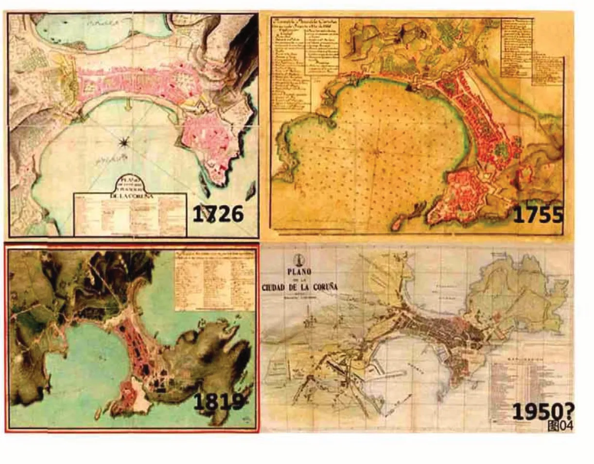
图04 18世纪以来拉科鲁尼亚市的国土城市规划发展。Fig.04 Territorial urban planning evolution of La Coruña since XVIII century.
此外,我们还以联合国教科文组织的世界生物圈保护区候选案例“拉科鲁尼亚海洋与陆地生物圈保护区”为例子,研究了为当地绿色战略增添连续性的可能性。拉科鲁尼亚海洋与陆地生物圈保护区是具有高度自然价值的枢纽中心,同时也是将西班牙北部的生态网络从庇里牛斯山脉延伸到大西洋的重要区域。
4 研究方法
我们所使用的方法包括,对拉科鲁尼亚市新总体规划与绿色系统现状进行分析与评估。根据欧洲标准,从绿色空间的连接性、影响的区域、空间的分布、类型、可达性以及协调性等几个不同方面进行分析。
我们使用SWOT分析,评估绿色基础设施规划中必须考虑的不同变量,同时还应用了绿色空间分布的地域分析。为了研究绿色廊道以及绿色基础设施对于公众健康的重要性,我们利用GVSIG项目,以可达性为依据,把距离最小的绿色区域300m为最大距离作为参考,对绿色廊道与绿色基础设施对于拉科鲁尼亚市的适用性进行了评估。该方法是由CE(ECI,2003)提议、根据自然英格兰机构的可达自然绿色空间标准(ANGST )和其他的学术研究来制定的(图03)。
根据UE的推荐,我们选定的绿色区域的最小尺寸为5 000m2(除了交通中央分隔带以及难以到达的绿色区域之外)。这一尺寸能够满足人们在远离都市繁嚣的自然环境中进行各种能够预防糖尿病与高胆固醇等疾病的体育活动,如散步或慢跑最少30分钟等。
另外,我们对还划定了能够改善可达性的潜在生态网络、各种枢纽(自然枢纽、历史枢纽或社会价值枢纽)以及最具有农业气息的、能够提供大量绿色元素的连接点。这一方法随着西班牙其他城市绿色战略分析提出的观点而得到了补充。
5 结果

表01 拉科鲁尼亚市绿色空间面积分布
5.1 改善拉科鲁尼亚市(LCG)绿色规划的必要性
在欧洲,有许多不同层次的绿色基础设施实施举措与建议(马萨等人,2011;诺曼等人,2011),并逐日在不同情况得到应用。它们虽各具特色,但由于各种现实障碍,如技术障碍、财政障碍、物理障碍与法律障碍,或仅仅是因为对这一领域的知识认识不深而非都大获成功,但总体来说这些障碍都是可以克服的。拉科鲁尼亚市作为最具城市化的自治区,是众多高密度(6 417居住人口/km2)中型城市(310 000常住人口)的案例中比较值得关注的一个。该市的绿色空间在尺寸、外观(半岛)与类型上都十分独特,为城市带来了别致的特色。但当谈及绿色空间结构改善、绿色系统规划与管理优化,拉科鲁尼亚市同样存在着一定的困难。
拉科鲁尼亚市拥有良好的海(传统港口与新的对外港口)、陆(N VI与A9)、空(阿尔维德罗机场)交通基础设施,但其辖区面积却十分有限(97.83 km2)。这不仅阻碍了该市的空间增长,同时引起了大量问题。实际上,拉科鲁尼亚市是西班牙人口密度最大的城市之一,其人口比1900年已经翻了五番。该市现状与历史发展的研究显示,该市的国土开发与自然之间的整合其实并不协调(图04)。

图05 a 拉科鲁尼亚市绿色区域的空间分布;b 绿色空间的可达性分析(面积>5 000m2,距离<300m)与重点区域标记;c 绿色廊道网络,PGOM 2012的高园以及枢纽中心整合与连接提案。Fig.05 (a) Spatial distribution of green areas in La Coruña.(b) Accessibility analysis to green spaces with S >5 000 m2 and distance <300m.Critic zones identification. (c) Green corridors network,Parque Alto of PGOM 2012 and proposal of hubs (natural,historic and cultural) incorporation and connections.
拉科鲁尼亚市的新总体规划(PGOM)提出了上述方法,虽然它有点偏离学术方向,且也是一种建设性建议,只是从一个更加复杂的角度,提出了绿道规划中连接性、功能性、公共健康和可达性等有限的建议,但该总体规划是一个带着充足提案的有趣开端。
另外一个影响拉科鲁尼亚市的重要障碍是加利西亚显著的农村特征,特别是城郊区域。然而,反过来说,这又是一个能够连接更加城市化的区域的巨大优势。这一优势已极大程度上强调了绿色基础设施不同部分的心理认知,这意味着拉科鲁尼亚市的人们其实并不理解这种国土规划的意义所在。
同样地,如果该绿色系统与附近区域缝合起来,充分利用世界生物圈保护区候选案例“拉科鲁尼亚海洋与陆地生物圈保护区”的优势(例如毗邻各自治区)的话,将能够增加西班牙北部生态网络的连续性,一直连接至大西洋。
5.2 空间分析
通过对拉科鲁尼亚市的绿色空间的初步分析,我们有了足够的信息来确定人们的需求是否得到满足,各区域的绿色系统是否需要改善。为此,我们以300m的影响区域(除去中央隔离岛与难以到达的区域)为基础进行了第二次分析。通过GIS分析,我们确定了能够制定精确方案(图05a)以保证所有人对绿色空间的可达性。
研究结果表明,拉科鲁尼亚市目前的人均公园面积比是8.2m2/人,与世界卫生组织规定的数值十分接近。虽然国际上对于这一数据的见解各有不同,例如,阿伯克龙比在其伦敦规划(1943-1944)上就建议最好的数值是16.2m2/人。而目前发达国家所使用的绿色空间通用标准是人均20m2的公园面积。如果我们采用这一通用标准,那么意味着我们仍需付出大量的努力。
据我们预算,尽管该市大部分都是小型绿色空间。但它的绿色区域空间分布是充分。因此,我们以GIS分析的结果为基础,对这些关键点进行了分析(图05b),这是因为小型绿色空间同样也十分重要。傅与赵(2010)在他们的研究中指出,人们通常都更习惯于在这些小型绿色空间上休闲与锻炼,因为相对于距离远的大型绿色空间,人们更喜欢更方便到达小型绿色空间。
虽然大多数公园与花园都是小于1 000m2的微型空间,但总体来说拉科鲁尼亚市的公园与花园系统的分布是相当广泛的(表01)。实际上,几乎100%的居民都能够在半径为300m的范围内接触到绿色空间(任何类型与尺寸),但几乎没有人能够接触到最小面积为5 000m2的公园,因为所有的大型公园都只建造在城市最边缘的区域。这些公园一部分是通过利用废弃军事设施而进行设计的,如面积达205 000m2的圣佩德罗公园(图06),它从某种意义上保护了该地的自然生物多样性。面积为600 000m2的本斯公园则是通过老市政区域设计设计改造而成(图07),其前身是一个废弃城市垃圾填埋场,而面积为50 000m2的圣玛格丽塔公园则来自旧城市野营区的改造。

图06 圣佩德罗公园(废弃军事用地):a 俯瞰图;b 迷宫。Fig.06 San Pedroñs park (old military battery).:(a)Aerial view.(b) Maze.

图07 本斯公园(废弃城市垃圾堆填区)。Fig.07 Ben´s park (old municipal garbage dump).

图08 LCG的潜在枢纽中心示意图与改善绿色基础设施的绿色连接点。Fig.08 Scheme of the potential hubs in LCG and green connection points to improve green infrastructure.
不同的公园区域能够充当不同枢纽中心(图08),经过确定,我们将其分成3个类别:(1)自然区域:德洛斯·罗萨莱斯公园、海格力士塔公园、波蒂诺木栈道、埃米尼亚塔。(2)历史花园:门德斯努涅斯花园(1867)(图09a)、圣卡洛斯花园(1834)(图09b)、阿兹卡拉格广场(约1896)。(3)文化公园:海格力士公园(世界遗产)(图10)与卡斯特罗埃尔维纳遗址(图11)。这些核心公园由廊道连接,成为了空间上互相联系的新系统支柱,为人们带来全新空间与享受自然的新机遇。
除了数量之外,一个至关重要的因素是公园的质量。在这个意义上来看,拉科鲁尼亚市市政府的投资是十分慷慨的,因为它是西班牙所有市政府中,对公园管理的投资比率(欧元/平方米)最高的市政府,而且投资的效果在人们看来也是十分积极的。
对于绿色廊道,我们也对PGOM提案进行了分析,并用更现实的绿色基础设施概念对其进行了补充。然而,由于拉科鲁尼亚市的城市类型,它有时是不可行的。另一方面,根据初步空间分析显示,在被联合国教科文组织选为生物圈保护区的地区,可以增加绿色基础设施的建设(图12-13)。
6 西班牙其他实践的分析
我们对在西班牙实施的其他实践活动进行了分析。由于历史发展、形态学、物理环境、人口、预算等因素,这些分析都存在大量的决疑论特征。我们根据相似性或对拉科鲁尼亚市的启发性为基础,选取了其中3个实践的例子。
维多利亚市的居住人口与拉科鲁尼亚市十分接近(243 298人),而密度相对较小,约840人/km2。该市的绿色规划是西班牙的范例,而且被誉为“绿色欧洲之都(2012)”。该市的城市绿带是上世纪90年代初的一个宏大计划的成果,是一组拥有高生态与景观价值的、由廊道相互连接的郊区公园。最近的一个研究表明,维多利亚市的城市绿带在某种程度上能够让人们在穿越到城市另外一个地方时享受到西班牙最好的生活质量。该研究调查了西班牙30个城市,涉及11项相关指标,并指出最大的担忧在于公众健康。
这一例子使我们感到兴趣的原因是,其一体化管理、公共广播草案、社会参与方案以及空间奇异性能够启发像拉科鲁尼亚这样的城市。而且其政府决策者正以联合国教科文组织所宣布的生物圈保护区为例子,对形成高地绿带的区域整合进行研究。该研究的其中一个目的是精确地分析LCG绿色系统与拉科鲁尼亚海洋与陆地生物圈保护区的每一个细节。
另外一个例子是巴伦西亚。该市拥有较高的城市密度(5 995.7人/km2),而且都市区由4个宏伟的景观聚合而成,环境优美,拥有优质景观资源。他们尝试将景观与城市环境以及农业、文化与自然空间连接起来并进行共同保护,用的就是我们案例中关于枢纽中心中提议的方法。最后一个例子是穆尔西亚自治区(430 571居住人口)。虽然它只是一个区域性的实践,但其在参与的欧洲项目(保护与享受自然)中关于运用财政、技术与政治手段实行绿色基础设施措施的实践方面上引起了我们浓厚的兴趣。

图0 9 历史枢纽中心:a 门德斯努涅斯历史花园(1867);b 圣卡洛斯历史花园(1834)。Fig.09 Historical hubs:(a) Mendez Núñez historical garden(1867).(b) San Carlos Historical gardens (1834).

图10 海格力士塔(世界遗产)。公元前1世纪。文化枢纽中心。Fig.10 Hercules´ Tower (World Heritage).1st century BC.Cultural hub.

图11 卡斯特罗埃尔维纳遗址(公元前3世纪),文化枢纽中心。Fig.11 Castro de Elviña(3rd century AC.),Cultural hub.

图12 UNESCO划分的生物圈保护区中“拉科鲁尼亚海洋与陆地生物圈保护区”的典型景观图。Fig.12 View of typical landscape of“Mariñas coruñesas e Terras do Mandeo”declared Reserve Biosphere by UNESCO.

图13 拉科鲁尼亚市的城市空间与城郊农业区域连接的可能性,以及西班牙保护空间网络。Fig.13 Potentiality of La Coruña city spatial connection with the peripheral agricultural zones and network of protected spaces in Spain.

图14 新城市规划:绿色基础设施、人、城市、健康以及福利。Fig.14 New Urban planning:Green infrastructure,people,cities,health and welfare.

图15 梅拉灯塔(拉科鲁尼亚)。UNESCO划分的生物圈保护区中“拉科鲁尼亚海洋与陆地生物圈保护区”的典型景观图。Fig.15 Lighthouse at Mera (La Coruña).Typical landscape of“Mariñas coruñesas e Terras do Mandeo”declared Reserve Biosphere by UNESCO.
7 SWOT分析
7.1 优势
(1)物理环境十分适合国土规划与自然环境的整合。环境的回应能力十分快。(2)城市的地貌能够允许建设蓝色基础设施。(3)在更多的乡村区域能够进行外延发展规划。(4)城市再生敏感度高。
7.2 劣势
(1)对绿色基础设施概念与原则的忽视。由于没有全球规划与明确的领导者,造成部门间缺乏对话沟通。(2)土地地貌单一,使规划变得复杂。(3)城市类别(街道狭窄,开放空间少等)。(4)城市密度高。(5)历史规划脱节。(6)法律与财政制度。
7.3 机会
(1)信息与教育;社会参与;社会意识觉醒。(2)国土规划使城市亲近最具有农业与自然气息的环境。(3)具有历史、自然或文化重要性的枢纽中心的认同与存在。(4)由生态系统利益带来的管理成本节省。(5)公众健康与生活质量的提高。健康的影响评估对于政治评价决策来说十分重要也十分有用。(6)申报“拉科鲁尼亚海洋与陆地生物圈保护区”的可能性。(7)经济复兴的潜力。
7.4 威胁
(1)经济危机。(2)社会压力。心理障碍。(3)特殊利益。(4)新城市干预断章取义。(5)缺乏评估健康利益的方法,影响其实施。
8 讨论与总结
目前,已有大量研究证实了在类似拉科鲁尼亚市这样的密集城市整合与实施绿色基础设施策略的必要性,因为这些策略能够改善公众健康,提升生活质量与景观质量,并作为一个有竞争力的全球优势为城市服务。
综合前期的研究工作,结合SWOT矩阵图与地理研究,我们可以看到,在拉科鲁尼亚市建设绿色基础设施存在着巨大的战略机遇。通过实施这一战略,人们就能够方便到达并使用300m以内的尺寸为5 000m2以上的大型绿色空间。这样,既达到欧洲标准,也改善了公众健康(图14)。
同时,我们还了解到实施区域性规划以增强西班牙南部保护区域的空间连续性,进而连接到大西洋的必要性(图15)。我们必须通过各种教育活动改变人们对绿色基础设施规划的理解,通过将西班牙人的现有观念从“公共设备”转变为“绿色基础设施”,不断发扬与宣传绿色基础设施的概念及其带来的广大利益。
1 Introduction
The last UNFPA statistical data showed that over the 50% of the world's population has lived in urban areas since 2010.Although it's true that cities offer multiple opportunities (jobs,knowledge,culture,…) also it is true that they have a negative aspect in everything related with the fast pace of life,the lack of leisure areas,the social incohesion and public health.Among the different alternatives that may be suggested to try to minimize this problem and look for more healthy cities,inside a global sustainability framework,stands out the green infrastructure (GI).As we know,green infrastructure,regardless of their different conceptual approaches and contexts,discussed deeply by many authors (Benedict and McMahon,2006;Sylwester,2009),is a strong multiscale planning strategy whose use is booming in the international panorama.Undeniably,both GI and its various components as green corridors,parks,gardens,etc ...have a strong nature of multifunctionality that is supported by numerous scientific and technical studies (Fabos,1995;Tzoulas et al.2007) and form a complex system that produces multiple benefits,including public health (PH).
In a case study of the city of La Coruña(northeast of Spain,Fig.01) (LCG),we have analyzed as the approach of GI on a municipal and provincial scale may be the suitable solution to numerous existing problems in medium-sized cities,with a high population density and with some appearance peculiarities,geographical siting and psychology barriers,connecting it with the benefits that are generated to public health in a double aspect:prevention and economical savings.
2 Background and Literature Review
We are aware that the rapid urbanization has caused numerous changes in public health and in social welfare because the nature has been replaced with modern environments,holding the population up to complicated situations.This fact is aggravated in more overcrowded cities with little public space where the incidence of diseases is greater owing to a lack of space to practice sports,heat island effect,greater level of pollution,etc.It is the case of cities as LCG which do not offer,in general,some appropriate surroundings for the inhabitants above all because they lack suitable areas that cause numerous and valuable ecosystemic benefits that work synergistically like palliative of diseases and systems of public health prevention.
A rising body of scientific evidences suggests that the contact with green spaces (GS) in its different typologies improves the health visibly,perhaps,by the biophilic feeling,a term coined by Erich Fromm and Wilson (1984) (Fig.02).A study of Maas et al.(2006) shows a positive relationship among the number of green spaces in the environment where people live and their health perception.Other studies show that the residents of areas with a suitable GI have a longer longevity,do more physical activity and are healthier.If we remember the definition adopted by the WHO:"health is a state of complete physical,mental,and social well-being and not merely the absence of disease or infirmity",we can deduce a direct connection with the green planning of the cities because health is considered as a phenomenon not only somatic (biological) and psychological,but also social.
It is important to keep in mind that one of the GI benefits is to protect vulnerable populations from factors that cause diseases,that is,the primary preventive intervention (PPI) of a public health system that is applied before disease occurs,as a result the most effective one,in economic savings and the fight against these diseases.This perspective appears from the PH origins and has been considered by its founders as Virchow.Therefore,we share the ideas of Kuppuswamy (2009) who indicates that there exists a clear need to evaluate the potential economic implications of the GI linked to health effects and the budget of health services facilitating interdisciplinary studies for urban planning.
The advantage of the use of territorial planning approaches that it is aimed at the hybridization between grey and green infrastructure is evident,on an urban scale,in numerous studies and theories that pursue the use of technical and scientific guidelines to make a more modern urbanism and nicer environments,or as Mohsen Mostafavi quoted,an ecological urbanism,landscape urbanism according to Charles Waldheim or James Corner approaches,looking for "landscape in the city and the city in the landscape" and,in a landscape planning and design more coherent in the conceptual line of the greenways (Fábos,1995)and green infrastructure (Benedict and McMahon,2006).The result of this perspective,in short,and by definition is multiscalar (municipality,region,state…) and multifunctional because it generates different types of benefits such as a) minimize the effects of climate change:temperature regulation,fixation of CO2,VOCs and O3,b) regeneration territories;c) conservation of biodiversity and wildlife,d) improving interaction,inclusion and social cohesion (Forest Research,2008),e)economic growth and investment.But perhaps one of the most important is the aim of this paper:f) public health and well-being,GI is the key for improvement both physically and psychologically,recognition based on a body of evidences that shows that it can improve the quality of life,psychological health,welfare,increase life expectancy,etc.Many studies show that the use of vegetation is suitable to fight these diseases such as asthma and to minimize the presence of sunburn and skin cancer by lowering the temperature.Tzoulas et al.(2007) studied the implementation of GI and public health in its different variants(cardiovascular,immune,respiratory,digestive,skeletal,stress,positive emotions,attention and cognitive ability).In particular,it is associated with relaxation and to combat depression and promote general health (Stigsdotter,2005).Furthermore,Ribeiro and Dias (2010) argue that the benefits generated by green corridors can strongly contribute to place the urban landscape on the right track to improve the quality of cities and therefore its competitiveness.Another important point in this topic is the location and accessibility;there are different studies and experiences that relate directly the size,quality and location of green areas improvements in quality of life and public health(Maas et al.,2006).All these benefits represent convincing arguments that can serve as base for change proposals in territorial planning and to add new natural elements like thousands of trees,as it happened in New York (Wells,2012).
The implementation of GI strategies at municipal level represents a competitive benefit of comprehensive planning more effective that reinforces the areas character,improves the connectivity and the cohesivity,the biodiversity,minimizes the fragmentation and works in more rational parameters of ecological coherence and of preservation,part of these proposals has been analyzed by different authors like Ribero and Barao(2006).And the other hand,it includes strategies to protect the landmarks,population identity and to avoid deterioration processes of urban landscape,of urbanalización,term coined by the Spanish geographer Frances Muñoz who combines the two Spanish words urbanización (urbanization)and banalización (trivialize).Through all these perspectives,we put forward a thesis that GI can contribute significantly to improve public health and quality of life,with the consequent economical savings,for that,the accessibility of all population to this kind of spaces must be guaranteed.
3 Goals and Objectives
The main purpose of this study is to explore,conceptualize and show,through LCG's case study,that GI is a necessary planning strategy for improving competitiveness and quality of life and are the key to reduce public health problems in its double aspect,prevention and an economical savings.Our objective is to consider the suitability of integrating these approaches in medium-sized cities with a high population density and with singular characteristics of appearance,size and types of green spaces such as the city of La Coruña.An incorporation that allows to suggest strategies to guarantee the accessibility of all the citizens to green spaces and guarantee the ecological connectivity.
Moreover,the possibility of suturing and giving continuity to this green local strategy with the candidacy of "Mariñas coruñesas e Terras do Mandeo" for World Biosphere Reserve by Unesco is being studied,because it represents a hub with natural value and the opening of Northern Spain ecological network which extends from Pyrenees to the Atlantic Ocean.
4 Methods
The methodology involves the analysis and estimation of the current state of the green system and the new masterplan of La Coruña.The analysis is drawn from different perspectives:continuity of the system of green spaces,areas of influence,spatial distribution,type,accessibility and harmonization with European standards.
A SWOT analysis to evaluate the different variables that had to be taken into account in the proposal of the GI planning and a territorial analysis of green spaces distribution were used.To study the thesis that the green corridors and the GI are very important to the improvement of the PH,it was evaluated,by means of the GVSIG program,its applicability to La Coruña city in terms of accessibility,defined by using a maximum distance of 300 m to some green area of a minimum size determined as a reference,measure proposed by the CE (ECI,2003) and recommended by ANGST of Natural England (2010) and different studies like Wendel-Vos et al.(2004) among others (Fig.03).
The minimum size selected is 5000m2(dismissing those areas in median strips and hard to access locations) as recommended by UE and it meet the appropriate conditions to do different physical activities like walking or jogging for a minimum of 30 minutes,the recommended daily value of exercise to fight against diabetes,cholesterol,etc,by enjoying a natural environment unconnected with urban life.
Also,potential ecological networks,that allow to improve the accessibility,hubs (of natural,historic or social value) and connection points with the most agricultural periurban areas that offer spatial continuity of green mass,were identified.The approach is enriched with the incorporation of viewpoints emanated from the analysis of green strategies in other cities of Spain.
5 Results
5.1 The Need to Improve the Green Planning of La Coruña (LCG)
In Europe there are numerous initiatives and recommendations for GI implementation at different scales (Mazza et al.,2011;Nauman et al.,2011),and day by day applied in more scenarios with different characteristics,with more or less success due to the existence of barriers,often surmountable,of technical,financial,physical and legal nature,or simply because of a lack of deep knowledge of this philosophy.The case of the city of LCG,the most urban of this autonomous community,is an interesting case of medium-sized city (310,000 real inhabitants) with a high density(6417 inhab./km2) that shows singularities in size,appearance (peninsula),typology of green spaces,urban peculiarities,that lend a special character to the city and,also,problems when it comes time to can improve its structure and to suggest a strategic change of planning and management of its green system.
The city has very good transport infrastructures,by land (N VI and A9),sea (traditional harbor and new foreign harbor) and air (Alvedro airport) but it has a very little municipal area (37.83Km2) which prevents its spatial growth and causes the mass situation,in fact is one of the cities with greatest population density of Spain,which has been increased fivefold since 1900.The analysis of the current situation and of the historic evolution shows up that a territorial development of integration with the most natural part has not been followed (Fig.04).
The new master plan (PGOM),which raises these approaches although some what away from the more academic line,represents an interesting starting point with adequate proposals as Parque Alto,although,as a constructive criticism,only gives some limited proposals superficially from a more comprehensive and complex perspective in the GI conceptual line (connectivity,multifunctional,public health,accessibility,…).
Another important handicap perceived in La Coruña is that the marked rural character of Galicia,in general,and of the periurban areas of the city,in particular,and the other side,a great advantage which would be able to serve as a link with the more urbanest parts,has stressed the psychological perception of the GI different parts enormously,which means that the population does not understand the approach of this kind of territorial planning.
In the same way,this green system seems interesting to be sutured with adjacent areas,taking advantage of the possible declaration of a World Biosphere Reserve of "Mariñas coruñesas e Terras do Mandeo",UNESCO candidate,which includes neighboring municipalities,as it would mean giving continuity to the ecological network in northern Spain and open it to the Atlantic.
5.2 Spatial Analysis
The first analysis relating to the situation of GS in LGC supplies us with the details to know if the citizens' needs are well covered and the zones whose green system need be improved.To this end,an analysis with influence zones of 300 m(dismissing those areas located in median strips and hard to access places) was carried out.After GIS analysis,we identified the weak points where would be precise to make proposals (Fig.05) to guarantee the accessibility of all the population.
The results emanated of the current situation show that there is a ratio of 8,2m2/inhab.,very close to the ratio proposed by WHO,although on the international level exists quite controversy,for example,Abercrombie suggested 16,2m2/inhab.in his plan to London (1943-1944).Currently,developed countries are adopting a general standard of green space of 20m2park area per capita.If this standard is adopted,we have a lot of hard work ahead of us.
It is estimated that the spatial distribution of green areas is adequate,although the most are small GS.For this reason,it is proposed that the critical points were analyzed based on results of GIS analysis (Fig.05),in spite of they are also important because,as Fu and Zhao (2010) pointed out in their study,sometimes they are more frequently used to rest and to do exercise since,in certain situations,the residents prefer near small areas than far and big zones.
The spatial distribution of parks and gardens system is very broad although the most part of them(177) are microspaces smaller than 1000m2(Table 1),in fact,almost the 100% of the residences have access to green zones (any type and size) within a radius of 300 meters,but few of them have access to parks of minimum dimensions (>5000m2).Large parks exist only in the most perimeter zones,parks that have been designed ex novo using either old military installations,thanks to which,in certain way,a great natural biodiversity has been kept and it was possible to outline a 205,000m2park (San Pedro Park) (Fig.06) or old municipal areas like Bens Park (600,000m2) (Fig.07),old municipal landfill,or Saint Margarita Park,old urban camping(50,000m2).
Different areas,that would be able to work perfectly as hubs (Fig.08),have been identified and classified in three typologies:a) natural:Parque de los Rosales.Parque de la Torre de Hércules.Paseo marítimo del Portiño.Punta Herminia;b)Historic Gardens:Méndez Nuñez (1867) (Fig.09.a).Jardín de San Carlos (1834) (Fig.09.b).Plaza de Azcarraga (circa 1896) and c) Cultural:Parque de la Torre de Hércules (World Heritage)(Fig.10) and Castro de Elviña (Fig.11).These cores would be able to be part of the backbone of the spatially interconnected new system,linked by means of corridors and offering new spaces and opportunities to be in touch with nature.
One factor hugely important besides the quantity is the quality,in that sense,the municipal government is generous because it is one of the city councils of Spain that invests the most ratio of euros/m2in its management and the result is very positive in population opinion.
Regarding green corridors,the new PGOM proposal has been analyzed and it has been complemented with new contributions more realist with GI concept,sometimes it is not possible because of the city urban typology.And the other hand,the preliminary spatial analysis would allow to join the potential GI of La Coruña with the area proposed to be declared Reserve Biosphere by the UNESCO (Fig.12 and 13).
6 Analysis of other Experiences in Spain
Different experiences carried out in Spain were analyzed,characterized by a large casuistry owing to the historic evolution,the morphology,physical environment,population,budget,etc,and three of them were selected by its similarities or by provided inspiration for La Coruña.
Vitoria has a number of inhabitants similar to La Coruña (243,298 inhab.) although with a minor density,840 inhab./km2.Its green planning represents the Spanish paradigm,evidence of that fact has been the appointment as "Green European Capital" (2012).Its green belt,645 has,the result of an ambitious plan that was started at the beginning of the years 90 of the last century,is a group of periurban parks with a high ecological and landscape value connected strategically by means of corridors which,in part,has enabled it to reach the second place among the cities with the greatest quality of life in Spain in a recent study carried out in 30 Spanish cities,taking into account 11 relevant indicators.The same study shows that one of the biggest worries is health.
This example interests us owing to its integral management,its protocol of public broadcasting,its social participative approach and its spatialsingularity that can be used as a guide for cities like La Coruña,and moreover,its policymakers are analyzing the integration of all the area that forms the highland belt in a group by means of Biosphere Reserve UNESCO Declaration of the whole area.One of the goals of this study is precisely to analyze the stitches of the green system of LCG with the possible appointment of Mariñas coruñesas e Terras do Mandeo.
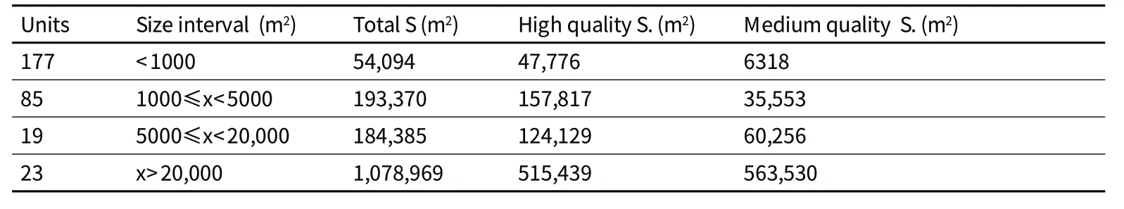
Table 1 :Distribution of green spaces surfaces at La Coruña.
Another interesting example is Valencia due to its high urban density (5995.7 inhab./km2),its metropolitan area is a territory of environmental and landscape excellence owing to the convergence of 4 great landscapes.They try to make the protection and connection of the landscapes with urban surroundings and agricultural,cultural and natural spaces,in the same way that it would be able to put into practice in the hubs identified in our case.The last example is Murcia (430,571 inhab.) although it is a regional initiative,we have a special interest in the experience of its participation in European projects (Reverse and Surf-Nature)with relation to financial,technical and political alternatives to carry out GI initiatives.
7 SWOT Analysis
7.1 Strengths:
(1)Physical environment very suitable for territorial planning proposals of integration with the natural environment.Capacity of response very fast.
(2)The city physiognomy allows the inclusion of Blue Infrastructure.
(3)Possible planning with perimeter growth in more rural zones.
(4)Sensibility to urban regeneration.
7.2 Weaknesses:
(1)Ignorance in relation to green infrastructure concepts and principles.Lack of dialogue among departments originated by the absence of a global project and a clear leadership.
(2)Singular territorial physiognomy.Complication in planning.
(3)Urban typology (narrow streets,little free areas,etc.)
(4)High urban density.
(5)Disjointed historic planning.
(6)Legal and financial framework
7.3 Opportunities:
(1)Information and education.Social participation.Social consciousness raising.
(2)Territorial planning joining the city closely to the most agricultural or natural environment.
(3)Identification and presence of hubs with special historic,natural or cultural importance.
(4)Savings of maintenance costs and derived from ecosystem benefits.
(5)Public health and quality of life improvement.The impact evaluation of health is important and very useful to make decisions in political evaluations.
(6)Possible declaration of "Mariñas coruñesas e Terras do Mandeo" like Reserve of the Biosphere.
(7) Potentiality of economic regeneration.
7.4 Threats:
(1)Economic crisis.
(2)Social pressure.Psychological barrier.
(3)Particular interests.
(4)New urban interventions taken out of context.
(5)The lack of methodologies that assess health benefits can affect its implementation.
8 Discussion and Conclusion
Studies developed and currently underway highlight the need to integrate and implement these planning strategies in dense cities with similar physical characteristics to those of La Coruña as they involve improving public health,quality of life and landscape,functioning as a competitive global advantage.
Synthesis of the preliminary research work,supported by the SWOT matrix and the geographical study,shows a strategic opportunity for the incorporation of GI in LGC that allows and guarantees the accessibility to green spaces bigger than 5000m2located within a radius minor than 300 m,following the European recommendations with the consequent improvement of public health(Fig.14).
It shows the need for regional planning to enhance and strengthen supramunicipal spatial connectivity of the protected areas network in northern Spain and open it to the Atlantic (Fig.15).GI planning must be accompanied by an informative and educational campaign adapted to the psychological bias of the population,transmitting its concept and its varied benefits with the aim of changing the current concept that exists in Spain of "public equipment" to "green infrastructure".
.
[1]Benedict M.A.,McMahon,Edward T.Green Infrastructure:Linking Landscapes and Communities[M].Washington:Island Press,2006.
[2]ECI.European Common Indicators:Towards a Local Sustainability Profile[R].Milano:Ambiente Italia Research Institute,2003.
[3]Fabos J.Gy.The Greenway Movement,Uses and Potentialities of Greenways[C]//Fabos J.Gy.,Ahern J. Greenways:The beginning of an international movement.Elsevier,1995:1-13.
[4]Forest Research.A valuation of the economic and social contribution of forestry for people in Scotland[R].Final report for Forestry Commission Scotland.Farnham:Forest Research,2008.
[5]Fu Fan and Zhao Caijun.Distributed Green Space System:An Implementable Green Infrastructure for the City[C]// Fábos J.Gy.,Ryan R.L.,Lindhult M.S.,Kumble P.,Kollányi L.,Ahern J.,Jombach S.Budapest,Hungary:2010:Proceedings of Fábos Conference on Landscape and Greenway Planning 2010,2010:285-291.
[6]Kuppuswamy,Hemavathy.Improving Health in Cities Using Green Infrastructure:a Review[R].FORUM Ejournal 9.Newcastle University,2009:63-76.
[7]Maas J.,Verheij R.A.,Groenewegen P.P.,de Vries S.Spreeuwenberg P.Green space,urbanity and health:how strong is the relation?[J]J.Epidem.and Comm.Health.2006,60(7):587–592.
[8]Mazza L.,Bennett G.,De Nocker L.,Gantioler S.,Losarcos L.,Margerison C.,Kaphengst T.,McConville A.,Rayment M.,ten Brink P.,Tucker G.,van Diggelen R.Green Infrastructure Implementation and Efficiency[R].Final report for the EC,DG Environment.2011.
[9]Naumann,Sandra,McKenna D.,Timo K.,Mav P.,Matt R.,Design,implementation and cost elements of Green Infrastructure projects[R].Final report to the EC,DG Environment.Ecologic institute and GHK Consulting,2011.
[10]Ribeiro,Luis,Barao,Teresa.Greenways for recreation and maintenance of Landscape quality:five case studies in Portugal[J].Landscape and urban planning.2006,76:79-97.
[11]Ribeiro,Luis,Dias,Teresa.Improving Small Cities Competitiveness through Greenway Planning and Design:Vila-Franca-de-Xira,Lisboa Metropolitan Area[C]// Fábos J.Gy.,Ryan R.L.,Lindhult M.S.,Kumble P.,Kollányi L.,Ahern J.,Jombach S.Budapest:2010:Proceedings of Fábos Conference on Landscape and Greenway Planning 2010,2010:79-86
[12]Tzoulas K.,Korpela K.,V.S.,Yli-Pelkonen V.,Ka zmierczak A.,Niemela J.,James P.Promoting ecosystem and human health in urban areas using Green infrastructure:A literature review[J].Landscape and Urban Planning,2007,81:167-178.
[13]Sylwester,Alexandra.Green infrastructure -Supporting connectivity,maintaining sustainability[J/OL].European Commission,DG Environment,2009[2013-10-25]. http://greeninfrastructureeurope.org/download/Discussion%20Paper%20 Green%20Infrastructure%20Aleksandra%20Sylwester.pdf
[14]Wendel-Vos GC,Schuit AJ,de Niet R,Boshuizen HC,Saris WH,Kromhout D.Factors of the physical environment associated with walking and bicycling[J].Med.Sci.Sports.Exerc,2004:36(4):725-30.
[15]Wells.Using urban forestry research in New York City[C]//Johnston M.,Percival G.Trees,people and the built environment.Edinburgh:FCResearch Report,2012:1–258.
[16]Wilson E.O.Biofilia.The human bond with other species[M].Cambridge,Boston,Massachusetts,USA:Harvard University Press,1984.
注释:
图01(a)资料来源:http://bancroft.berkeley.edu/philobiblon/resources_es.html.,图01(b)、图06(a)、图06(b)、图07、图09(a)、图09(b)、图10资料来源:拉科鲁尼亚市议会,图04资料来源:国防档案部,图11 资料来源:马尔维新等人,图12、图15 资料来源:玛丽娜斯-贝坦佐斯事务所。
猜你喜欢
品牌研究(2022年26期)2022-09-19
中国化肥信息(2022年5期)2022-08-30
清华金融评论(2022年4期)2022-04-13
海峡姐妹(2019年3期)2019-06-18
中国公路(2017年14期)2017-09-26
中亚信息(2016年3期)2016-12-01
足球周刊(2016年2期)2016-02-01
百科知识(2008年8期)2008-05-15
